
Emthanjeni Municipality is a local municipality within the Pixley ka Seme District Municipality, in the Northern Cape province of South Africa. Emthanjeni is a Xhosa word meaning "vein", symbolising the importance of an underground water supply system to the area. It is also a translation of the name of the municipality's seat, De Aar.

Gariep Local Municipality is a defunct local municipality in Joe Gqabi District Municipality, Eastern Cape. The municipality was merged with Maletswai Local Municipality immediately after the August 2016 Local Municipal Elections to form the new Walter Sisulu Local Municipality.

Umjindi was a local municipality of the Ehlanzeni District in Mpumalanga, South Africa. Barberton was the seat of the municipality. The municipality had a population of 53,744 according to the 2001 census.

Modimolle Local Municipality was a municipality located in the Waterberg District Municipality of Limpopo province, South Africa. The seat of Modimolle Local Municipality was Modimolle.
Thabazimbi Municipality is a local municipality within the Waterberg District Municipality, in the Limpopo province of South Africa. The seat is Thabazimbi.

Ventersdorp Local Municipality was a local municipality in Dr Kenneth Kaunda District Municipality, North West Province, South Africa. The seat of local municipality was Ventersdorp. After the municipal elections on 3 August 2016 it was merged into the larger JB Marks Local Municipality.

uMngeni Municipality is a local municipality within the Umgungundlovu District Municipality, in the KwaZulu-Natal province of South Africa. The municipality is named after the uMngeni River that runs through the municipal area.

uMhlathuze Local Municipality is an administrative area in the King Cetshwayo District Municipality of KwaZulu-Natal in South Africa. The municipality is named after the Mhlatuze River.

Indaka Local Municipality was an administrative area in the Uthukela District of KwaZulu-Natal in South Africa. The municipality is named after the Indaka River that runs through the municipal area.

uMdoni Municipality is a local municipality within the Ugu District Municipality, in the KwaZulu-Natal province of South Africa. uMdoni is the isiZulu name for the indigenous forest waterberry plant.

Camdeboo Local Municipality was a local municipality in the Sarah Baartman District Municipality of the Eastern Cape in South Africa. After municipal elections on 3 August 2016 it was merged into the larger Dr Beyers Naudé Local Municipality.

Ikwezi Local Municipality was a local municipality in the Sarah Baartman District Municipality of the Eastern Cape in South Africa. Ikwezi is an isiXhosa name that means "morning star". After municipal elections on 3 August 2016 it was merged into the larger Dr Beyers Naudé Local Municipality.

Naledi Local Municipality was a local municipality in the Free State province in South Africa. On 3 August 2016 it was disestablished and merged into the Mangaung Metropolitan Municipality. The name Naledi is a Sesotho word meaning "a star". The principal towns in the area of the disestablished municipality are Dewetsdorp and Wepener.

Hlabisa was an administrative area in the Umkhanyakude District of KwaZulu-Natal in South Africa. Hlabisa is an isiZulu surname of the two nkosis (kings) in the area. The municipality was situated within the vicinity of four Tribal Authorities which are the Mkhwanazi Tribal Authority, the Mdletshe Tribal Authority, and two Hlabisa Tribal Authorities.
Ezinqoleni Local Municipality was an administrative area in the Ugu District of KwaZulu-Natal in South Africa.

Nxuba Local Municipality formerly known as Cradock Local Municipality, was an administrative area in the Amatole District of the Eastern Cape in South Africa. The Fish River, as it is now called, was first named Nxuba River by King Sandile in the 18th century After municipal elections on 3 August 2016 it was merged into the larger Raymond Mhlaba Local Municipality.

Umtshezi Local Municipality was an administrative area in the Uthukela District of KwaZulu-Natal in South Africa. uMtshezi is an isiZulu name word for Bushman or San. The name uMtshezi refers to the Bushman River. After municipal elections on 3 August 2016, it was merged into the larger Inkosi Langalibalele Local Municipality.

Mthonjaneni is an administrative area in the King Cetshwayo District of KwaZulu-Natal in South Africa.

uMfolozi Local Municipality is a local municipality within the King Cetshwayo District Municipality of KwaZulu-Natal in South Africa. It is situated around the town of KwaMbonambi, to the north of Richard's Bay, stretching from the Indian Ocean to the edge of the Hluhluwe–Imfolozi Park.
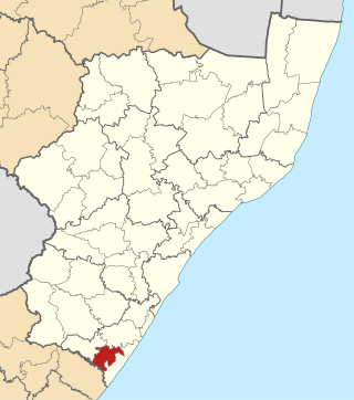
Imbabazane Local Municipality was an administrative area in the Uthukela District of KwaZulu-Natal in South Africa. Imbabazane is the name of an African tree. After municipal elections on 3 August 2016 it was merged into the larger Inkosi Langalibalele Local Municipality.


