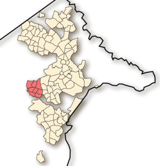
Weston Creek is one of the original eighteen districts of the Australian Capital Territory used in land administration. The district is subdivided into divisions (suburbs), sections and blocks. The district comprises eight residential suburbs, situated to the west of the Woden Valley district and approximately 13 kilometres (8.1 mi) southwest of the Canberra City centre. Situated adjacent to the district was the large Stromlo Forest pine plantation until the forest was destroyed by bushfires in 2001 and 2003.

Toongabbie is a suburb of Sydney, in the state of New South Wales, Australia. One of the oldest suburbs in Sydney, Toongabbie is located approximately 30 kilometres west of the Sydney central business district and is part of the Greater Western Sydney region. Toongabbie is split between the local government areas of the City of Parramatta, the City of Blacktown and Cumberland Council. The suburb is often locally referred to as "Toonie", "Toonga Bay" and "Bayside".
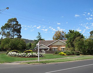
Colonel Light Gardens is a suburb located within the Australian City of Mitcham in the greater Adelaide region, approximately 7 km (4 mi) south of the Adelaide city centre. The area is 1.58 km2 (0.61 sq mi). Planned as a garden suburb, it is known for wide, tree-lined streets, presentable postwar bungalow homes, rounded street corners, and much manicured, well maintained open space.

Abbotsbury is a suburb of Sydney, New South Wales, Australia 39 kilometres west of the Sydney central business district in the local government area of the City of Fairfield. Abbotsbury is part of the Greater Western Sydney region.
Crowthorne is a suburb of Midrand, South Africa. It is located in Region A of the City of Johannesburg Metropolitan Municipality, between Pretoria and Johannesburg on the previously known Carlswald Agricultural Holdings. The region is surrounded by plots, horse breeding societies and agricultural activities; neighbouring areas like Beaulieu, Kyalami, Blue Hills etc. Crowthorne is known for the Crowthorne Shopping Centre, Crowthorne Lodge, new developments by Century Property Developments and several garden centres like the Plantland Nursery.
Bertrams is a suburb of Johannesburg, South Africa. It is a small suburb found on the eastern edge of the Johannesburg central business district (CBD), tucked between the suburbs of New Doornfontein and Lorentzville, with Troyeville to the south. It is located in Region F of the City of Johannesburg Metropolitan Municipality.

Narwee is a suburb in southern Sydney, in the state of New South Wales, Australia. Narwee is located 18 kilometres south of the Sydney central business district and is part of the St George area. Narwee is in local government areas of City of Canterbury-Bankstown and Georges River Council. The postcode is 2209, which it shares with neighbouring Beverly Hills.
Darch is a suburb of Perth, Western Australia, located within the City of Wanneroo approximately 17 kilometres (11 mi) north of the central business district. Previously part of Landsdale, much of the suburb was rural in character until the late 1990s. It was named after an early settler family in the area, with the name being approved in 1997. The area was subsequently opened to residential development, especially from 2001 onwards, as part of Cell 6 of the East Wanneroo Development Area.

Banjup is a suburb of Perth, Western Australia, located within the City of Cockburn. Its postcode is 6164. It is approximately 25 km (16 mi) south of the Perth central business district.
Blakehurst is a suburb in southern Sydney, in the state of New South Wales, Australia 18 kilometres south of the Sydney central business district, in the local government area of the Georges River Council. It is part of the St George area.
Cambridge Gardens is a suburb of Sydney, in the state of New South Wales, Australia. Cambridge Gardens is located 54 kilometres west of the Sydney central business district, in the local government area of the City of Penrith and is part of the Greater Western Sydney region.

Toorak Gardens is a leafy, mainly residential inner eastern suburb of Adelaide, South Australia, located 2 km east of the Adelaide city centre.

Morphett Vale is a southern suburb of Adelaide, South Australia in the City of Onkaparinga. It is the largest suburb in the state, with a population of more than 23,000 and an area of 12.76 km2, followed by Paralowie with nearly 10,000 fewer residents. There are approximately 1,000 businesses in Morphett Vale. The suburb is bordered by Sheriffs/Pimpala Road, Panalatinga Road, Doctors/Beach Road, and the Southern Expressway.
Emmarentia is a suburb of Johannesburg, South Africa.
Randpark Ridge is an upmarket suburb of Randburg, South Africa. It is located in the Randburg region of the City of Johannesburg. It fell into the town of Randburg during the apartheid era. Developed in the early 1980s and still relatively new, Randpark Ridge is bordered by several other suburbs including Weltevreden Park, Sundowner, Boskruin, Bromhof, Honeydew and Fairland. It is located on the north-west extremity of Johannesburg.

Runcorn is an outer southern suburb in the City of Brisbane, Queensland, Australia. In the 2016 census, Runcorn had a population of 14,592 people.
Duns Creek is a rural residential suburb in the Hunter Region of New South Wales, Australia, located near the historic village of Paterson in the north-western corner of the Port Stephens Council local government area.
Kensington B is a suburb in Randburg, which is an area located in northern Johannesburg, Gauteng, South Africa.
Paparangi, one of the northern suburbs of Wellington in New Zealand, lies approximately 10 km north of the city centre, north-east of Johnsonville, north-west of Newlands and south of Grenada and Woodridge. The population was 2,841 at the time of the 2013 census, an increase of 96 from the 2006 census population.

Westdene is a suburb of Johannesburg, South Africa. Westdene lies between the historic suburb of Sophiatown and Melville with the Melville Koppies West nature reserve to the north of the suburb. Westdene derives its name from its location, literally meaning west-valley. 'West' since it is located west from the city centre and with 'dene' derived from the Old English denu, meaning valley.

