
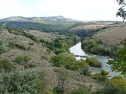
The Limpopo River rises in South Africa and flows generally eastward through Mozambique to the Indian Ocean. The term Limpopo is derived from Rivombo (Livombo/Lebombo), a group of Tsonga settlers led by Hosi Rivombo who settled in the mountainous vicinity and named the area after their leader. The river has been called the Vhembe by local Venda communities of the area where now that name has been adopted by the South African government as its District Municipality in the north, a name that was also suggested in 2002 as a possible title for the province but was voted against. The river is approximately 1,750 km (1,090 mi) long, with a drainage basin of 415,000 km2 (160,000 sq mi) in size. The mean discharge measured over a year is 170 m3/s (6,000 cu ft/s) to 313 m3/s (11,100 cu ft/s) at its mouth. The Limpopo is the second largest African river that drains to the Indian Ocean, after the Zambezi River.

The Vaal River is the largest tributary of the Orange River in South Africa. The river has its source near Breyten in Mpumalanga province, east of Johannesburg and about 30 kilometres (19 mi) north of Ermelo and only about 240 kilometres (150 mi) from the Indian Ocean. It then flows westwards to its confluence with the Orange River southwest of Kimberley in the Northern Cape. It is 1,458 kilometres (906 mi) long, and forms the border between Mpumalanga, Gauteng and North West Province on its north bank, and the Free State on its south.

The Molopo River is one of the main rivers in Southern Africa. It has a length of approximately 960 kilometres and a catchment area of 367,201 km2 with Botswana, Namibia and South Africa sharing roughly about a third of the basin each.

The Olifants River,Lepelle, iBhalule or Obalule is a river in South Africa and Mozambique, a tributary of the Limpopo River. It falls into the Drainage Area B of the Drainage basins of South Africa. The historical area of the Pedi people, Sekhukhuneland, is located between the Olifants River and one of its largest tributaries, the Steelpoort River.

The Jukskei River is one of the largest rivers in Johannesburg, South Africa. It is the southernmost river in the Crocodile River basin.

Hartbeespoort Dam is an arch type dam situated in the North West Province of South Africa. It lies in a valley to the south of the Magaliesberg mountain range and north of the Witwatersberg mountain range, about 35 kilometres north west of Johannesburg and 20 kilometres west of Pretoria. The name of the dam means "dam at the gorge of the hartebeest" in Afrikaans. This "poort" in the Magaliesberg was a popular spot for hunters, where they cornered and shot the hartebeest. The dam was originally designed for irrigation, which is currently its primary use, as well as for domestic and industrial use. The dam is considered to be in a hypereutrophic state since the early 1970s. Mismanagement of waste water treatment from urban zones within the Hartbeespoort Dam catchment area is largely to blame, having distorted the food web with over 280 tons of phosphate and nitrate deposits.

The N4 is a national route in South Africa that runs from Skilpadshek on the Botswana border, past Rustenburg, Pretoria, eMalahleni and Mbombela, to Komatipoort on the Mozambique border. The entire route is a toll road.

The Rietvlei dam is an earth-fill type dam and is one of a number of dams supplying water to the Pretoria region of South Africa. It supplies around 41 million liters of drinking water daily, about 5.9% of the water requirement of Pretoria. The dam mainly serves for municipal and industrial use. Its hazard potential has been ranked high (3).

The Hennops River is one of the larger rivers that drains Gauteng, South Africa. It has its source near Kempton Park, east of Johannesburg and meets the Crocodile River shortly before Hartbeespoort Dam. It is one of Gauteng's most polluted rivers.

Roodeplaat Dam is a concrete arch dam situated in South Africa on the Pienaars River, a tributary of the Crocodile River, which flows northwards into the Limpopo River. The dam is a warm monomictic impoundment with stable thermal stratification during the summer.

Bospoort Dam is a gravity/earth-fill type dam on the Hex River, a tributary of the Elands River, part of the Crocodile River (Limpopo) basin. It is located near Rustenburg, North West, South Africa. Its primary purpose is for irrigation.

The Levubu River or Levuvhu is located in the northern Limpopo province of South Africa. Some of its tributaries, such as the Mutshindudi River and Mutale River rise in the Soutpansberg Mountains.

The Pienaars River is a river in South Africa. It is a tributary of the Crocodile River. A short section of this river is known as the Moretele River. Tributaries of the Pienaars River include the Moreletaspruit. Note that the above-mentioned Moretele river section is 60 km away from the Moreletaspruit and these two should not be confused with one another.

The Marico River or Madikwe is a river in Southern Africa. There are a number of dams in its basin. Groot Marico town is named after the Marico River. After it is joined on its right bank by the Crocodile River it is known as the Limpopo River.
Drainage Basin A, is one of the drainage basins of South Africa. The main river in this system is the Limpopo River. It is subdivided into 9 sub-drainage basins.

The Notwane River is a river in southeastern Botswana. Certain sections of its course form the international boundary with South Africa. Its mouth is at the head of the Limpopo River. It has a catchment area of 18,053 square kilometres (6,970 sq mi).

The Rietvlei River is a small river in central Gauteng Province, South Africa. It feeds the wetlands of the Rietvlei Nature Reserve, before it flows into Rietvlei Dam, which is one of the main sources of water for Pretoria. The river downstream of the dam is known as Sesmylspruit, which is a tributary of the Hennops River and part of the Crocodile River (Limpopo) basin.

The Elands River is located in the North West Province, South Africa. It is a tributary of the Crocodile River, part of the Limpopo River basin.

The Elands River is a river in the former Transvaal area, South Africa. It is a tributary of the Olifants River, part of the Limpopo River basin.
The Vaalkop Dam is a combined gravity and earth-fill type dam located in North West Province, South Africa. Its reservoir is located at the confluence of the Elands River and the Hex River, part of the Crocodile basin. The dam was established originally in 1972 and was renovated in 2008 in order to supply water for the platinum and associated metals mining operations in the area. The dam mainly serves for irrigation purposes, municipal water supply and industrial uses. The hazard potential of the dam has been ranked high.


