
Pretoria, is South Africa's administrative capital, serving as the seat of the executive branch of government, and as the host to all foreign embassies to South Africa.

The Jukskei River is one of the largest rivers in Johannesburg, South Africa. It is the southernmost river in the Crocodile River basin.

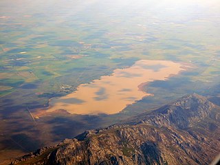
Hartbeespoort Dam is an arch type dam situated in the North West Province of South Africa. It lies in a valley to the south of the Magaliesberg mountain range and north of the Witwatersberg mountain range, about 35 kilometres north west of Johannesburg and 20 kilometres west of Pretoria. The name of the dam means "dam at the gorge of the hartebeest" in Afrikaans. This "poort" in the Magaliesberg was a popular spot for hunters, where they cornered and shot the hartebeest. The dam was originally designed for irrigation, which is currently its primary use, as well as for domestic and industrial use. The dam is considered to be in a hypereutrophic state since the early 1970s. Mismanagement of waste water treatment from urban zones within the Hartbeespoort Dam catchment area is largely to blame, having distorted the food web with over 280 tons of phosphate and nitrate deposits.

The Gariep Dam is located in South Africa, near the town of Norvalspont, bordering the Free State and Eastern Cape provinces. Its primary purpose is for irrigation, domestic and industrial use as well as for power generation. It the largest dam in South Africa.

The N4 is a national route in South Africa that runs from Skilpadshek on the Botswana border, past Rustenburg, Pretoria, eMalahleni and Mbombela, to Komatipoort on the Mozambique border. The entire route is a toll road.

The Hennops River is one of the larger rivers that drains Gauteng, South Africa. It has its source near Kempton Park, east of Johannesburg and meets the Crocodile River shortly before Hartbeespoort Dam. It is one of Gauteng's most polluted rivers.

Roodeplaat Nature Reserve is located on the shores of the Roodeplaat Dam, 22 km north-east of Pretoria, Gauteng.
Churchill Dam, is a multi-arch type dam located at the Kromme River, near Kareedouw, Eastern Cape, in South Africa. It was established in 1943 and its main purpose is for municipal and industrial usage.
Voëlvlei Dam is a dam located in the Western Cape, South Africa near the town of Gouda. The earth-fill wall is 2,910 metres (9,550 ft) long and 10 metres (33 ft) high. The reservoir covers an area of 1,524 hectares and has a capacity of 168,000 megalitres, making it the second-largest reservoir in the Western Cape Water Supply System. Water from the reservoir is supplied to water treatment works of the City of Cape Town and the West Coast District Municipality, and can also be released into the Berg River for agricultural purposes or to fill the Misverstand Dam.

The Crocodile River is a river in South Africa. At its confluence with the Marico River, the Limpopo River is formed.

Steenbras Upper Dam is an earth-fill type dam located in the Hottentots Holland Mountains above Gordons Bay in the Western Cape, South Africa. It impounds the Steenbras River upstream of the older Steenbras Dam. The dam was constructed in 1977 for the City of Cape Town and serves mainly for municipal and industrial use. The hazard potential of the dam has been ranked high (3).

The Pienaars River is a river in South Africa. It is a tributary of the Crocodile River. A short section of this river is known as the Moretele River. Tributaries of the Pienaars River include the Moreletaspruit. Note that the above-mentioned Moretele river section is 60 km away from the Moreletaspruit and these two should not be confused with one another.

The R511 is a Regional Route in South Africa that connects Sandton with Thabazimbi via Hartbeespoort and Brits.
The R512 is a Regional Route in South Africa that connects Brits, North West with Randburg, Gauteng via the western side of Hartbeespoort. It is an alternative route to the R511 for travel between the Johannesburg Metropole and Brits.
The R513 is a Regional Route in South Africa that connects Hartbeespoort with Bronkhorstspruit via Akasia, Pretoria North and Cullinan.
The R573 is a Regional Route in South Africa that connects Pretoria with Marble Hall via KwaMhlanga and Siyabuswa. As the road passes through Moloto, the entire route is known as the Moloto Road. It is maintained by the South African National Roads Agency.

Faerie Glen Nature Reserve is a nature reserve at the western limit of the Bronberg in the east of Pretoria, South Africa. It is adjacent to the suburb of Faerie Glen.
Joan Sydney Whitmore was a South African hydrologist specialising in agriculture and water. She wrote a book about drought management on farmland, and many reports on water and agriculture, during her career as a government scientist. She had risen to the rank of Director by 1972, which was an unusual achievement for a woman at that time...
The Hex River is a tributary of the Breede River located in the Western Cape of South Africa. The most important settlements along the river are the small towns of De Doorns and Touws River.

The Magaliesberg Protected Natural Environment is one of two core zones found within the Magaliesberg Biosphere Reserve along the Magaliesberg mountain range in South Africa, from Rusternberg to Pretoria.


