
Camp H. M. Smith is a United States Marine Corps installation in the Hawaiian town of Aiea on the island of Oahu, near the community of Halawa (ha-LA-va) Heights. It is the headquarters of the United States Indo-Pacific Command (INDOPACOM), Special Operations Command Pacific, and Marine Forces Pacific, the Marine service component command of INDOPACOM.

Betula papyrifera is a short-lived species of birch native to northern North America. Paper birch is named for the tree's thin white bark, which often peels in paper like layers from the trunk. Paper birch is often one of the first species to colonize a burned area within the northern latitudes, and is an important species for moose browsing. The wood is often used for pulpwood and firewood.

Bear Head Lake State Park is a state park of Minnesota, United States, providing ready access to outdoor recreation in the Boundary Waters region. It boasts scenery similar to the nearby Boundary Waters Canoe Area Wilderness, with the added conveniences of road access, modern facilities, and motorboating. The most popular visitor activities are boating, fishing, swimming, and hiking. The park entirely surrounds 670-acre (270 ha) Bear Head Lake and three other fishing lakes. It was established in 1961 in Saint Louis County near Ely, Minnesota. The park also contains the woodlands surrounding the lakes, which gives an entire total of about 5,540 acres. The park also shares a large border with Bear Island State Forest.

Hugh Taylor Birch State Park is a Florida State Park located in Fort Lauderdale, on East Sunrise Boulevard, between the Intracoastal Waterway and SR A1A.
Beartown State Forest is a publicly owned forest with recreational features located in the towns of Great Barrington, Monterey, Lee, and Tyringham, Massachusetts. The state forest's more than 10,000 acres (4,000 ha) include 198 acres (80 ha) of recreational parkland. It is managed by the Massachusetts Department of Conservation and Recreation.

Lake Dennison Recreation Area is a 121-acre (49 ha) Massachusetts state park located in the town of Winchendon. It comprises a small portion of the 4,221 acres (1,708 ha) of the U.S. Army Corps of Engineers' Birch Hill Flood Control Project that are managed by the Department of Conservation and Recreation and that also include Otter River State Forest.

The Millers River is a 52.1-mile-long (83.8 km) river in northern Massachusetts, originating in Ashburnham and joining the Connecticut River just downstream from Millers Falls, Massachusetts. Sections of the river are used for whitewater kayaking, and a section upriver is popular with flatwater racers, and the river is known locally as a good place for pike fishing.
The Glen Helen Nature Preserve is a nature reserve immediately east of Yellow Springs, Ohio, United States. The initial 700-acre parcel was given to Antioch College by Hugh Taylor Birch in memory of his daughter Helen Birch Bartlet in 1929, and is the largest private nature preserve in the region.

Birch Bay State Park is a 194-acre (79 ha) Washington state park located nine miles (14 km) south of Blaine in Whatcom County. The park has 8,255 feet (2,516 m) of saltwater shoreline on Birch Bay and 15,000 feet (4,600 m) of freshwater shoreline along Terrell Creek. Recreational opportunities include camping, picnicking, fishing, hiking, crabbing, clamming, and boating.
Turnor Lake is a community on the southern shore of Turnor Lake. From Highway 155 it is accessible by Highway 909. The community includes the Northern Hamlet of Turnor Lake and Turnor Lake 193B of the Birch Narrows First Nation.
Birch Lake is a lake 1.5 miles (2.4 km) south of Barnsdall, Oklahoma, Oklahoma, 20 miles (32 km) southwest of Bartlesville and 30 miles (48 km) northwest of Tulsa. The drainage area for Birch Lake is 66 square miles (170 km2). Its area covers 1,137 acres (4.60 km2). The total capacity is: 52,800 acre-feet (65,100,000 m3), subdivided into: Conservation 15,800 acre-feet (19,500,000 m3), Flood control 39,000 acre-feet (48,000,000 m3), and Inactive storage 15,840 acre-feet (19,540,000 m3).
Birch Creek Airport is a state-owned, public-use airport located one nautical mile (1.85 km) north-northwest of the central business district of Birch Creek, in the Yukon-Koyukuk Census Area in the U.S. state of Alaska.
The Bear Island State Forest is a state forest in Minnesota bordered by the towns of Ely, Babbitt, and Tower in Lake and Saint Louis counties. It is adjacent to the Burntside State Forest and the federally managed Superior National Forest and Boundary Waters Canoe Area Wilderness. It is managed primarily by the Minnesota Department of Natural Resources and the counties.
The Birch Lakes State Forest is a state forest located in Stearns County, Minnesota. One of the smallest Minnesota state forests, it is managed primarily for recreation by the Minnesota Department of Natural Resources. Big Birch Lake, a 2,112 acres (855 ha) sand- and marl-bottomed lake, is accessible from the northeast corner of the forest. The forest is located in a transitory ecotone between the temperate deciduous forest to the northeast and the tallgrass prairie to the southwest, with the rolling terrain characteristic of the glacial activity in the area.
Wuskwi Sipihk First Nation is a Swampy Cree First Nations band government whose reserve community is located northeast Birch River, Manitoba, along the western shores of Swan Lake. The Rural Municipality of Mountain (North) forms the western and southern borders of the reserve. As of April, 2011, the First Nation had a total registered population of 623 people, of which 197 people lived on their own Indian reserve. The current Chief for the First Nation is Elwood Zastre.
Birch Point State Park is a public recreation area occupying 62 acres (25 ha) on Penobscot Bay in the town of Owls Head, Knox County, Maine. The state park features a sandy, crescent-shaped "pocket beach" with scenic views of the Muscle Ridge Islands dotting Muscle Ridge Channel. The park is managed by the Maine Department of Agriculture, Conservation and Forestry.
Birch Island Run is a stream in Cameron County and Clinton County, Pennsylvania in the United States. It is a tributary of the West Branch Susquehanna River and is 7.2 miles (11.6 km) long. There are a number of coal seams in the Birch Island Run watershed, as well as iron ore. Mining has been done in the watershed. The watershed is 15.3 square miles in area and is almost entirely forested. The stream's tributaries include Little Birch Island Run and Amos Branch. Parts of the watershed are affected by acid mine drainage. However, brook trout live in the stream.
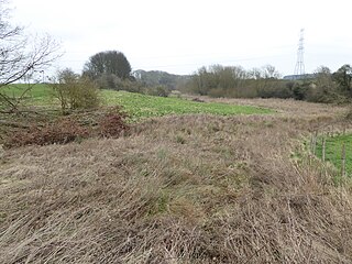
Birch Spinney and Mawsley Marsh is a 12.3-hectare (30-acre) biological Site of Special Scientific Interest north-west of Broughton in Northamptonshire.

The Blue Mountain-Birch Cove Lakes Wilderness Area is located in Halifax, Nova Scotia, Canada. Considered to be of high ecological value, it is one of 40 designated wilderness areas in the province.
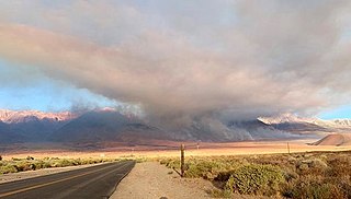
The Taboose Fire was a wildfire burning in Inyo National Forest, southwest of Big Pine and northwest of Aberdeen in Inyo County in the state of California, in the United States. The fire started September 4, 2019 and on October 7, it had burned 10,296 acres (4,167 ha) and was 75 percent contained. The cause of the fire was lightning. Select trails, campgrounds and roads in Inyo National Forest, Sequoia National Park and Kings Canyon National Park had been closed due to the fire. The community of Baxter Ranch was under mandatory evacuation.


