Fort Berkeley

Last updated
Fort Berkeley
English Harbour, Antigua
Antigua - View from the Dow Hill Fort - Fort Berkeley - panoramio.jpg
View of Fort Berkeley remains
Antigua location map.svg
Red pog.svg
Fort Berkeley
Caribbean location map.svg
Red pog.svg
Fort Berkeley
Coordinates 17°00′N61°46′W / 17.00°N 61.76°W / 17.00; -61.76
Type Fortification
Site information
Open to
the public
Yes
ConditionPartially restored
Site history
Built1704
In use1700s-1820s

Fort Berkeley is a historic military fort on the island of Antigua. It is located at the entrance to English Harbour in Saint Paul parish. The fort was built in 1704 and expanded in the mid 18th century. It is part of Nelson's Dockyard National Park [1] and the Antigua Naval Dockyard and Related Archaeological Sites UNESCO World Heritage Site. [2]

Contents

History

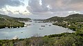
Fort Berkeley was built in 1704, on a peninsular strip of land at the entrance to English Harbour. [1] [3] It was originally a simple fortification, consisting of an enclosed area with a gate and guardhouse. [4] A construction of the Antiguan government, the fort was manned by government hires rather than by soldiers. [1]

In 1745, Fort Berkeley was significantly expanded and upgraded with the development of English Harbour's Naval dockyard. [3] The first half of the new battery was built by the Antiguan government. The second half was built by the Royal Navy under Commodore Charles Knowles. [3] According to Knowles, he commissioned the construction's completion after the Antiguan government refused to continue funding the construction. [3] As a result, the two halves of the battery were built with two different architectural and tactical styles. [3] The British government criticized and removed Commodore Knowles from his post for involving the British in the completion of the battery, which they saw as an Antiguan government responsibility. [3]

After its expansion in the 1740s, Fort Berkeley had a magazine and a guardhouse, and was armed with 29 guns: 19 mounted cannons and an additional battery of 10 guns belonging to the Navy. [3] Additionally, the fort had an iron chain that was strung across the harbour's entrance from Fort Charlotte. [4] The chain could be raised to prevent vessels from entering the harbour. [4]

In 1783, the Antiguan government turned the fort over to the British Navy. [3] In 1807, the British added the gunpowder magazine to the fort. [1] There is evidence that Fort Berkeley was used as a quarantine station. [4] In 1843, an earthquake destroyed most of Fort Berkeley's original wall. [5]

The current remains of Fort Berkeley include the powder magazine, guard house, crenelated walls, and a canon from 1805 in its original position. [3] The fort is accessible via a short nature trail called Fort Berkeley Trail. [1] [4]

In 1984, Fort Berkeley became part of Nelson's Dockyard National Park. [6] [7] In 2016, it became part of a UNESCO World Heritage Site, as UNESCO recognized the English Harbour dockyard and the surrounding military archaeological sites together as "The Antigua Naval Dockyard and Related Archaeological Sites." [8] [9]

Preservation

Stabilization projects have been implemented due to waves eroding the peninsula on which the Fort sits. [4] Nelson's Dockyard National Park began a maintenance program to keep the walls of Fort Berkeley intact to deflect the storm surges. [4] Antigua's National Parks Authority have discussed plans for further stabilization of the ruins and protection of the peninsula and the harbour. [10] [11]

Related Research Articles

<span class="mw-page-title-main">Antigua and Barbuda</span> Country in the Lesser Antilles of the West Indies

Antigua and Barbuda is a sovereign island country in the Caribbean. It lies at the conjuncture of the Caribbean Sea and the Atlantic Ocean in the Leeward Islands part of the Lesser Antilles.

<span class="mw-page-title-main">Martello tower</span> Small defensive fort

Martello towers, sometimes known simply as Martellos, are small defensive forts that were built across the British Empire during the 19th century, from the time of the French Revolutionary Wars onwards. Most were coastal forts.

<span class="mw-page-title-main">Fort Henry National Historic Site</span> National historic site and fort in Kingston, Ontario

Fort Henry National Historic Site is located in Kingston, Ontario, Canada on Point Henry, a strategic, elevated point near the mouth of the Cataraqui River where it flows into the St. Lawrence River at the east end of Lake Ontario. The fort and the point on which the fort was built were named after Henry Hamilton, former Lieutenant-Governor of the Province of Quebec.

<span class="mw-page-title-main">Portland Harbour</span> Port in Dorset, England

Portland Harbour is located beside the Isle of Portland, Dorset, on the south coast of England. Construction of the harbour began in 1849; when completed in 1872, its 520-hectare (1,300-acre) surface area made it the largest human-made harbour in the world, and it remains one of the largest in the world today. It is naturally sheltered by Portland to the south, Chesil Beach to the west and mainland Dorset to the north. It consists of four breakwaters: two southern and two northern. These have a total length of 4.57 km (2.84 mi) and enclose approximately 1,000 ha of water.

<span class="mw-page-title-main">Fort Cumberland (England)</span> Palmerston fort in Southsea

Fort Cumberland is a pentagonal artillery fortification erected to guard the entrance to Langstone Harbour, east of the Dockyard of Portsmouth on the south coast of England. It was sited to protect the Royal Navy Dockyard, by preventing enemy forces from landing in Langstone Harbour and attacking from the landward side. Fort Cumberland is widely recognised as the finest example of a bastion trace fort in England. It is a scheduled monument and a Grade II* listed building

<span class="mw-page-title-main">Saint Paul, Antigua and Barbuda</span> Parish in Antigua and Barbuda

Saint Paul, officially the Parish of Saint Paul, is a parish of Antigua and Barbuda on the island of Antigua. Saint Paul borders Saint Peter and Saint John to the north, Saint Mary to the west, and Saint Philip to the east. Saint Paul is dominated by farmland in the north, with various creeks and Potworks Dam marking its northern border, and low-lying hills to the south, defining its western border with Saint Mary. The largest city fully within the parish is Liberta, the fourth largest city in the country. The parish capital, and the location of the parish church, is Falmouth. The main economic and tourism hub of the parish is English Harbour. Saint Paul was created with the other five original parishes on 11 January 1692. It had a population of 9,004 in 2018.

<span class="mw-page-title-main">Antigua</span> Island in Antigua and Barbuda

Antigua, also known as Waladli or Wadadli by the native population, is an island in the Lesser Antilles. It is one of the Leeward Islands in the Caribbean region and the most populous island of the country of Antigua and Barbuda. Antigua and Barbuda became an independent state within the Commonwealth of Nations on 1 November 1981.

<span class="mw-page-title-main">English Harbour</span> Town in Antigua, Antigua and Barbuda

English Harbour is a natural harbour and settlement on the island of Antigua in the Caribbean, in the extreme south of the island. The settlement takes its name from the nearby harbour in which the Royal Navy established its base of operations for the area during the eighteenth century. Its population is 759.

<span class="mw-page-title-main">Nelson's Dockyard</span>

Nelson's Dockyard is a cultural heritage site and marina in English Harbour, located in Saint Paul Parish on the Caribbean island of Antigua, in Antigua and Barbuda. It was built in the early 18th century and abandoned by the British Navy in 1889.

<span class="mw-page-title-main">Dawes Point Battery</span> Historic site in New South Wales, Australia

The Dawes Point Battery remains is a heritage-listed former artillery fortification and now visitor attraction located adjacent to the southern pylon of the Sydney Harbour Bridge at Hickson Road in inner city Sydney, on the boundary between Dawes Point and The Rocks in the City of Sydney local government area of New South Wales, Australia. It was built and modified from 1791 to 1925 by Lieutenant William Dawes, Robert Ross, Francis Greenway, and George Barney. The property is owned by Property NSW, an agency of the Government of New South Wales. It was added to the New South Wales State Heritage Register on 10 May 2002.

<span class="mw-page-title-main">Historic Town of St George and Related Fortifications, Bermuda</span> UNESCO World Heritage Site in British Overseas Territories, United Kingdom

The Historic Town of St George and Related Fortifications is the name used by the United Nations Educational, Scientific and Cultural Organization's (UNESCO) World Heritage Committee to identify collectively as a World Heritage Site St. George's Town, founded in 1612, and a range of fortifications, batteries, and magazines built between 1612 and 1939, the last of which was removed from use in 1953.

<span class="mw-page-title-main">Western Redoubt</span>

The Western Redoubt, or Fort William, is a square fort built on a crest on the eastern side of Government Hill, and within the boundaries of the original main British Army camp in the Imperial fortress colony of Bermuda, St. George's Garrison.

<span class="mw-page-title-main">Fort George, Bermuda</span>

Fort George is a square fort built on the crest of Mount Hill to the west of St. George's Town, near to, but outside of the boundaries of the original main British Army camp in the Imperial fortress colony of Bermuda, St. George's Garrison.

<span class="mw-page-title-main">Dow's Hill Interpretation Centre</span> Antiguan museum

Dow's Hill Interpretation Centre is a museum on Antigua. The hill was part of the estate of Archibald Dow, a civilian Royal Navy official, before it was acquired for the construction of fortifications. Dow's House became a residence for senior garrison officers and then the Governor of the Leeward Islands before it was destroyed by an 1834 earthquake. The museum was established in 1989 with funding from the Canadian International Development Agency and provides a presentation of Antiguan history and tours of nearby ruins.

<span class="mw-page-title-main">Fort Barrington, Antigua and Barbuda</span>

Fort Barrington is a historic military fort in Antigua and Barbuda. It is located on Goat Hill in St. John's, Antigua, at the western entrance to St. John's Harbor. The fort was built in 1779, and was named for Admiral Samuel Barrington. Remains of the fort include a circular battery, small magazine, and barracks.

<span class="mw-page-title-main">Shirley Heights, Antigua and Barbuda</span>

Shirley Heights is an historic military compound in Antigua. It was built in the 1780s to protect the Naval Dockyard in English Harbour. It is part of Nelson's Dockyard National Park and part of a UNESCO World Heritage Site.

Fort Charlotte was a historic military fort on the island of Antigua, built in 1745 and later expanded. It was located at the entrance to English Harbour in Saint Paul parish. Originally called South East Point Battery and renamed Horseshoe Battery, the fort was finally renamed in honour of Queen Charlotte. The remains of the fort are part of Nelson's Dockyard National Park and part of the Antigua Naval Dockyard and Related Archaeological Sites UNESCO World Heritage Site.

<span class="mw-page-title-main">Antigua Naval Dockyard and Related Archaeological Sites</span> World heritage site in Antigua and Barbuda

The Antigua Naval Dockyard and Related Archaeological Sites is a 255 ha UNESCO World Heritage Site in Saint Paul Parish, Antigua, Antigua and Barbuda. It constitutes a collection of Georgian era naval structures, namely a naval dockyard and related supporting compounds. This maritime complex was established during a period marked by intense competition among European nations vying for dominance at sea to secure authority over the profitable sugar-producing islands in the Eastern Caribbean.

References

  1. 1 2 3 4 5 "Forts | Nelson's Dockyard National Park". www.nationalparksantigua.com. Retrieved 2023-10-24.
  2. Centre, UNESCO World Heritage. "Antigua Naval Dockyard and Related Archaeological Sites". UNESCO World Heritage Centre. Retrieved 2023-10-10.
  3. 1 2 3 4 5 6 7 8 9 Waters, Christopher Kurt (2018). "Putting Forts in Their Place: The Politics of Defense in Antigua, 1670-1785". Syracuse University Libraries (Doctoral Dissertation). Syracuse University . Retrieved 2023-10-23.
  4. 1 2 3 4 5 6 7 "The Antigua Naval Dockyard and Related Archaeological Sites: World Heritage Site Nomination Document" (PDF). UNESCO World Heritage Convention. 2014. Archived from the original (PDF) on July 5, 2020.
  5. Vaitilingam, Adam (2001). The Rough Guide to Antigua and Barbuda. Rough Guides. ISBN   978-1-85828-715-7.
  6. Stanford, Emma; Hanna, Nick (2016-10-04). National Geographic Traveler - The Caribbean: Ports of Call and Beyond. National Geographic Books. ISBN   978-1-4262-1709-8.
  7. "Shirley's Heights | Nelson's Dockyard National Park". www.nationalparksantigua.com. Retrieved 2023-10-09.
  8. Centre, UNESCO World Heritage. "Antigua Naval Dockyard and Related Archaeological Sites". UNESCO World Heritage Centre. Retrieved 2023-10-10.
  9. "About the National Park | Nelson's Dockyard National Park". www.nationalparksantigua.com. Retrieved 2023-10-10.
  10. "Ambassador and delegation from US Embassy tour Nelson's Dockyard National Park". Antigua Observer. 25 July 2023.
  11. "Italian Government partners with Antigua's National Park on Climate Change Adaptation & Heritage Site Preservation". Antigua Observer. 17 May 2023.