Related Research Articles
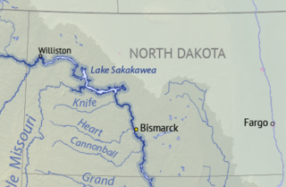
Lake Sakakawea is a large reservoir in the north central United States, impounded in 1953 by Garrison Dam, a U.S. Army Corps of Engineers dam located in the Missouri River basin in central North Dakota. Named for the Shoshone-Hidatsa woman Sakakawea, it is the largest man-made lake located entirely within North Dakota, the second largest in the United States by area after Lake Oahe, and the third largest in the United States by volume, after Lake Mead and Lake Powell.

Garrison Dam is an earth-fill embankment dam on the Missouri River in central North Dakota, U.S. Constructed by the U.S. Army Corps of Engineers from 1947 to 1953, at over two miles (3.2 km) in length, the dam is the fifth-largest earthen dam in the world. The reservoir impounded by the dam is Lake Sakakawea, which extends to Williston and the confluence with the Yellowstone River, near the Montana border. The dam and resulting reservoir inundated approximately one-sixth (16.6%) to one-fourth (25%) of Fort Berthold Indian Reservation's land, resulting in the loss of homes, farmland, and community infrastructure for the Three Affiliated Tribes.
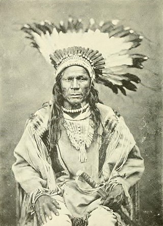
The Mandan, Hidatsa, and Arikara Nation, also known as the Three Affiliated Tribes, is a federally recognized Native American Nation resulting from the alliance of the Mandan, Hidatsa, and Arikara peoples, whose Indigenous lands ranged across the Missouri River basin extending from present day North Dakota through western Montana and Wyoming.

The Arikara War was a military conflict between the United States and Arikara in 1823 fought in the Great Plains along the Upper Missouri River in the Unorganized Territory. For the United States, the war was the first in which the United States Army was deployed for operations west of the Missouri River on the Great Plains. The war, the first and only conflict between the Arikara and the U.S., came as a response to an Arikara attack on U.S. citizens engaged in the fur trade. The Arikara War was called "the worst disaster in the history of the Western fur trade".

The Hidatsa are a Siouan people. They are enrolled in the federally recognized Three Affiliated Tribes of the Fort Berthold Reservation in North Dakota. Their language is related to that of the Crow, and they are sometimes considered a parent tribe to the modern Crow in Montana.
The Arikara, also known as Sahnish, Arikaree, Ree, or Hundi, are a tribe of Native Americans in South Dakota. Today, they are enrolled with the Mandan and the Hidatsa as the federally recognized tribe known as the Mandan, Hidatsa, and Arikara Nation.

The Mandan are a Native American tribe of the Great Plains who have lived for centuries primarily in what is now North Dakota. They are enrolled in the Three Affiliated Tribes of the Fort Berthold Reservation. About half of the Mandan still reside in the area of the reservation; the rest reside around the United States and in Canada.

Fort Abraham Lincoln State Park is a North Dakota state park located 7 miles (11 km) south of Mandan, North Dakota, United States. The park is home to the replica Mandan On-A-Slant Indian Village and reconstructed military buildings including the Custer House.
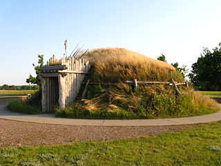
The Knife River Indian Villages National Historic Site, which was established in 1974, preserves the historic and archaeological remnants of bands of Hidatsa, Northern Plains Indians, in North Dakota. This area was a major trading and agricultural area. Three villages were known to occupy the Knife area. In general, these three villages are known as Hidatsa villages. Broken down, the individual villages are Awatixa Xi'e, Awatixa and Big Hidatsa village. Awatixa Xi'e is believed to be the oldest village of the three. The Big Hidatsa village was established around 1600.

The Crow Creek Indian Reservation, home to Crow Creek Sioux Tribe is located in parts of Buffalo, Hughes, and Hyde counties on the east bank of the Missouri River in central South Dakota in the United States. It has a land area of 421.658 square miles (1,092.09 km2) and a 2000 census population of 2,225 persons. The major town and capital of the federally recognized Crow Creek Sioux Tribe is Fort Thompson.

The Fort Berthold Indian Reservation is a U.S. Indian reservation in western North Dakota that is home for the federally recognized Mandan, Hidatsa, and Arikara Nation, also known as the Three Affiliated Tribes. The reservation includes lands on both sides of the Missouri River. The tribal headquarters is in New Town, the 18th largest city in North Dakota.

Four Bears Bridge is one of two bridges built over the Missouri River on the Fort Berthold Reservation in the U.S. state of North Dakota. It carries North Dakota Highway 23. The current bridge which opened in 2005 is the second largest bridge in the state and replaced an earlier bridge built in 1934. The 1934 bridge was moved in 1955 following the construction of the Garrison Dam and the creation of Lake Sakakawea.
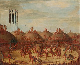
Like-a-Fishhook Village was a Native American settlement next to Fort Berthold in North Dakota, United States, established by dissident bands of the Three Affiliated Tribes, the Mandan, Arikara and Hidatsa. Formed in 1845, it was also eventually inhabited by non-Indian traders, and became important in the trade between Natives and non-Natives in the region.
Edward Lone Fight served as Chairman of the Mandan, Hidatsa and Arikara Nation from 1986 to 1990. In 1988 Lone Fight met with President Ronald Reagan, a meeting which was the catalyst for the Just Compensation Bill, introduced based on the findings of the Joint Tribal Advisory Committee, which provided the tribes partial compensation for the flooding of reservation due to the construction of the Garrison Dam under the Pick-Sloan Legislation.
Twin Buttes is an unincorporated community in Dunn County, North Dakota, United States. It is a community on the Fort Berthold Indian Reservation, which is home of the Mandan, Hidatsa, and Arikara Three Affiliated Tribes. Twin Buttes is 2 miles (3.2 km) south of Lake Sakakawea, and 12 miles (19 km) north-northeast of Halliday.
Alyce Spotted Bear was a Native American educator and politician and an enrolled member of the Mandan, Hidatsa, and Arikara Nation.
This timeline of South Dakota is a list of events in the history of South Dakota by year.
Crow Flies High was the chief of a band of dissident Hidatsa people from 1870 until their band joined the reservation system in 1894. This band was one of the last to settle on an Indian reservation. A North Dakota State Park is named after him.
Raymond "Ray" Cross was an American attorney and law professor from the U.S. state of North Dakota. He was a member of the Mandan, Hidatsa, and Arikara Nation, also known as the Three Affiliated Tribes, and a former professor of American Indian Law at the University of Montana. As an attorney, Cross represented Native Americans in multiple landmark trials, including two U.S. Supreme Court cases, and successfully won a compensation claim against the U.S. government for the flooding of 156,000 acres of tribal land in North Dakota due to the construction of the Garrison Dam.
Elbowoods is a ghost town that was located in McLean County, North Dakota, United States, on the Fort Berthold Indian Reservation. It was founded in 1889 along the Missouri River as the agency seat for the reservation of the Mandan, Hidatsa, and Arikara Nation. After the creation of the Garrison Dam and Lake Sakakawea, rising water levels threatened the town, slowly engulfing its buildings until the entire town was submerged in 1954.
References
- ↑ Berthold, Bartholomew (1780-1831). Berthold family papers (1785-1954.) http://collections.mohistory.org/archive/ARC:A0119 Archived 2013-12-02 at the Wayback Machine
- ↑ "The Civil War Muse - the Berthold Mansion".
- ↑ U.S. Geological Survey Geographic Names Information System: Fort Berthold
- ↑ Fort Berthold Reservation in 1950 Archived 2010-11-03 at the Wayback Machine , from Discovering Lewis & Clark ®, http://www.lewis-clark.org © 1998-2009 VIAs Inc. © 2009 by The Lewis and Clark Fort Mandan Foundation, Washburn, North Dakota. Includes a map showing the land flooded by the Lake Sakakawea reservoir and the location of flooded towns, homes and Fort Berthold.