Fort Carondelet

Last updated
USA Missouri location map.svg
Red pog.svg
Fort Carondelet
Fort Carondelet

Fort Carondelet was a fort located along the Osage River in Vernon County, Missouri, constructed in 1795 as an early fur trading post in Spanish Louisiana by the Chouteau family. [1] The fort also was used by the Spanish colonial government to maintain good relations with the Osage Nation. Sold by the Chouteau family in 1802, the fort was abandoned the same year by its new owners. [2] By the time of an 1806 visit by Zebulon Pike on his expedition through southern Louisiana, the buildings were in disrepair. [3] Although archaeological remains of the fort and its buildings were extant in 1874, [4] a congregation known as the Church of Israel (affiliated with the Christian Identity movement) has occupied the site since the 1940s. [5]

Contents

Origins

Starting in the mid-1700s, the Osage Nation traded furs with French and Spanish settlers, especially the French brothers Pierre Chouteau and Auguste Chouteau from the settlement of St. Louis. The Chouteaus were authorized to trade by the Spanish colonial government, and by 1787 built a temporary trading post along the Osage River in what is now western Missouri. [6]

Francisco Luis Hector, Baron of Carondelet, namesake of Fort Carondelet Retrato del Baron de Carondelet - Anonimo (siglo XIX).jpg
Francisco Luis Hector, Baron of Carondelet, namesake of Fort Carondelet

Spanish Governor General Esteban Rodríguez Miró first proposed a fort in western Missouri in 1791, looking to strengthen Spanish allies living among the Osage. [7] Before the fort was built, Miro was replaced as Spanish governor general by Francisco Luis Héctor de Carondelet. [8] Concerned that the Osage would ally themselves with the French, Carondelet requested a peace meeting with six Osage chiefs in mid-1794, at which the Osage chiefs agreed (in exchange for peace) to allow the construction of the fort. Carondelet was informed that the fur trader, Auguste Chouteau, would financially support the construction of the fort as a replacement for his temporary trading post along the Osage River. [9] [10] In a letter to Carondelet, Chouteau described the proposed fort buildings in detail:

The said stronghold is to be composed of two parts: The first shall be of brick or stone and the second of logs ten inches square laid horizontally one upon the other, as the Americans practice. It shall form a perfect square each side of thirty-two feet. The second part shall be placed diagonally, that is, so that each side shall cut and correspond to the angle of the first story, and each angle to the middle side of the second story, by which means those defending the top can exterminate with hand-grenades and guns through the holes in the plankwork, all those who attempt to force the door or approach the base of the wall.

The planking of the first story floors shall be at least three inches thick unless the contractor prefer to use tight bricks or stone of same dimensions. That of the second story shall be at least two inches thick and that of the garret shall be of common boards.

The elevation of the first story shall be ten feet between first and second floors, that of the second story nine feet in the same manner. The roof shall have a height of six or eight feet and be covered with tiles, bricks, slate or mud. All the woodwork shall be sustained by four posts, set at equal intervals in the interior of the edifices, on which the beam shall rest to insure greater solidity.

There shall be two embrasures in each facade of the first story, ten by eight inches square, for placing artillery on pillars with a very thick door as on the vessels. The door of the fort of the most solid nature with hinges, bolts and lock of iron, shall be feet high and five feet wide. The stairway to upper story shall be solid and well conditioned; there shall be on each side of second story, ten loop-holes for guns feet over the floor, and two at the extremities of the lower sides at a height of six feet, so that they can be used by mounting on a chair without danger of the enemy being able to insert guns to fire into the lower story.

Auguste Chouteau, Letter to Carondelet, New Orleans, May 18, 1794. [11]

Given his desire for peace with the Osage, Carondelet accepted Chouteau's proposal. According to the terms of the agreement between Chouteau and Carondelet, Chouteau received $2,000 annually to support twenty soldiers at the fort and a six-year monopoly on trade with the Osage, unless the Spanish government itself supplied the soldiers (in which case, Chouteau would receive the monopoly but no more). [10]

Use and abandonment

After its construction in 1795, Fort Carondelet was used as the farthest western outpost for the Chouteau trading operations and not as a military fort. [12] Pierre Chouteau operated the post, bringing his sons to live among the neighboring Osage. His sons in turn became familiar with the culture of the Osage and the life of indigenous peoples in general. [13] For their part, members of the Osage Nation accepted Chouteau and his family. [14] Other tribes (such as the Miami) became jealous of the perceived favoritism shown to the Osage Nation. [14]

One of the major effects of the fort was its role in expanding the Chouteau trade operation. While commander of the fort, Pierre Chouteau (along with his son, Auguste Pierre Chouteau) expanded trade from Fort Carondelet to other Osage settlements near the Arkansas River by 1796. [12] By 1800 rivals to the Chouteau operation began demanding that the government break its contract monopoly. [2] That same year, new Spanish Governor General Juan Manuel de Salcedo gave the Chouteau's trade rights to one of their Spanish rivals, Manuel Lisa. In 1802, abandoning his effort to maintain his monopoly, Pierre Chouteau sold Fort Carondelet to Lisa, who withdrew the garrison and abandoned the fort. [2] During the transfer of the Louisiana territory to the possession of the United States in 1804, Auguste Chouteau was employed by Spain to remove any remaining Spanish property from the fort. [15]

Zebulon Pike, American explorer who visited the site in 1806 Zebulon Pike.jpg
Zebulon Pike, American explorer who visited the site in 1806

After 1802, the fort's buildings fell into disrepair, and by 1806, they were overgrown with vegetation. [16] According to an entry in the journal of Zebulon Pike during his expedition through southern Louisiana:

We embarked at five o'clock and came twelve miles to breakfast. A four o'clock came to ten French houses on the east shore [of the Osage River], where was then residing a Sac, who was married to an Osage femme and spoke French only. We afterwards passed the position where Mr. Chouteau formerly had his fort, not a vestige of which was remaining, the spot being only marked by the superior growth of vegetation.

Zebulon Pike, Diary of the Pike Expedition, August 17, 1806. [17]

After the Pike Expedition, few travelers reported the site of the fort. The last report of the fort's existence derives from an 1874 Missouri travel guidebook relating the physical characteristics of Vernon County. [18] While not explicitly mentioning the fort, the guidebook noted the top of Halley's Bluff had "the foundations of three furnaces" and "the remains of works—both earth and stone, covering the approaches to the furnaces and the descent to the excavations below, as if thrown up for fortifications. [4] Later, the guidebook suggested that the works were remnants of French explorers who had built a headquarters for their operations there. [19]

In the early 20th century, Halley's Bluff (and the site of the fort) became the possession of a Mormon group that eventually separated from the Church of Christ (Temple Lot). [20] This group, known as the Church of Christ at Halley's Bluff, controlled the property as a compound from 1945 until 1979. [20] Since a dispute over control of the church in the 1970s, the compound has been the property of the Church of Israel, a Christian Identity group. [21] In the 1980s, the church compound was home to Eric Robert Rudolph, who committed the Centennial Olympic Park bombing in 1996. [21]

Notes

  1. Hoig, 21–24.
  2. 1 2 3 Hoig, 24.
  3. Neely, 16.
  4. 1 2 Campbell, 623.
  5. O'Neill, 1.
  6. Blackmar, 658.
  7. Burns, 127.
  8. Burns, 128.
  9. Burns, 129.
  10. 1 2 Houck, 210.
  11. Houck, 212.
  12. 1 2 Hoig, 23.
  13. Hoig, 21.
  14. 1 2 Hoig, 22.
  15. Hoig, 27.
  16. Houck, 145.
  17. Hart et al., 89.
  18. Campbell, 622–624.
  19. Campbell, 623–24.
  20. 1 2 Kaplan, 183.
  21. 1 2 O'Neill, 1

Related Research Articles

<span class="mw-page-title-main">Ste. Genevieve, Missouri</span> City in Missouri, United States

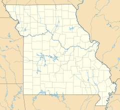
Ste. Genevieve is a city in Ste. Genevieve Township and is the county seat of Ste. Genevieve County, Missouri, United States. The population was 4,999 at the 2020 census. Founded in 1735 by French Canadian colonists and settlers from east of the river, it was the first organized European settlement west of the Mississippi River in present-day Missouri. Today, it is home to Ste. Genevieve National Historical Park, the 422nd unit of the National Park Service.

<span class="mw-page-title-main">Manuel Lisa</span>

Manuel Lisa, also known as Manuel de Lisa, was a Spanish citizen and later, became an American citizen who, while living on the western frontier, became a land owner, merchant, fur trader, United States Indian agent, and explorer. Lisa was among the founders, in St. Louis, of the Missouri Fur Company, an early fur trading company. Manuel Lisa gained respect through his trading among Native American tribes of the upper Missouri River region, such as the Teton Sioux, Omaha and Ponca.

<span class="mw-page-title-main">Pike Expedition</span> 1806-07 U.S. exploration of the southwest Louisiana Territory

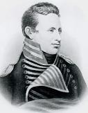
The Pike Expedition was a military party sent out by President Thomas Jefferson and authorized by the United States government to explore the south and west of the recent Louisiana Purchase. Roughly contemporaneous with the Lewis and Clark Expedition, it was led by United States Army Lieutenant Zebulon Pike, Jr. who was promoted to captain during the trip. It was the first official American effort to explore the western Great Plains and the Rocky Mountains in present-day Colorado. Pike contacted several Native American tribes during his travels and informed them that the U.S. now claimed their territory. The expedition documented the United States' discovery of Tava which was later renamed Pikes Peak in honor of Pike. After splitting up his men, Pike led the larger contingent to find the headwaters of the Red River. A smaller group returned safely to the U.S. Army fort in St. Louis, Missouri before winter set in.

<span class="mw-page-title-main">Joseph Nicollet</span> French geographer, astronomer, and mathematician

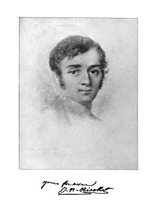
Joseph Nicolas Nicollet, also known as Jean-Nicolas Nicollet, was a French geographer, astronomer, and mathematician known for mapping the Upper Mississippi River basin during the 1830s. Nicollet led three expeditions in the region between the Mississippi and Missouri Rivers, primarily in Minnesota, South Dakota, and North Dakota.

<span class="mw-page-title-main">Osage Nation</span> Native American Siouan-speaking tribe

The Osage Nation, is a Midwestern American tribe of the Great Plains. The tribe developed in the Ohio and Mississippi river valleys around 700 B.C. along with other groups of its language family. They migrated west after the 17th century, settling near the confluence of the Missouri and Mississippi rivers, as a result of Iroquois expansion into the Ohio Country in the aftermath of the Beaver Wars.

<span class="mw-page-title-main">Auguste Chouteau</span>

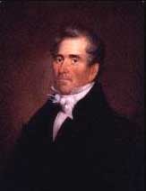
René-Auguste Chouteau, Jr., also known as Auguste Chouteau, was the founder of St. Louis, Missouri, a successful fur trader and a politician. He and his partner had a monopoly for many years of fur trade with the large Osage tribe on the Missouri River. He had numerous business interests in St. Louis and was well-connected with the various rulers: French, Spanish, and American.

<span class="mw-page-title-main">Fort Osage</span> United States historic place

Fort Osage was an early 19th-century factory trading post run by the United States Government in western Missouri on the American frontier; it was located in present-day Sibley, Missouri. The Treaty of Fort Clark, signed with certain members of the Osage Nation in 1808, called for the United States to establish Fort Osage as a trading post and to protect the Osage from tribal enemies.

<span class="mw-page-title-main">François Chouteau</span> American pioneer

François Gesseau Chouteau was an American pioneer fur trader, entrepreneur, and community leader known as the "Father of Kansas City". He was born in St. Louis, established the first fur trading post in the wild frontier of western Missouri, and settled the area that became Kansas City, Missouri. His first wife was of the Osage Nation and bore a son, and his second wife, Bérénice, birthed nine children.

<span class="mw-page-title-main">Treaty of Fort Clark</span> 1808 treaty between the United States and Osage

The Treaty of Fort Clark was signed at Fort Osage on November 10, 1808, in which the Osage Nation ceded all the land east of the fort in Missouri and Arkansas north of the Arkansas River to the United States. The Fort Clark treaty and the Treaty of St. Louis in which the Sac (tribe) and Fox (tribe) ceded northeastern Missouri along with northern Illinois and southern Wisconsin were the first two major treaties in the newly acquired Louisiana Purchase. The affected tribes, upset with the terms, were to side with the British in the War of 1812. Following the settlement of that war, John C. Sullivan for the United States was to survey the ceded land in 1816 (adjusting it 23 miles westward to the mouth of the Kansas River to create the Indian Boundary Line west of which and south of which virtually all tribes were to be removed in the Indian Removal Act in 1830.

<span class="mw-page-title-main">Jean-Pierre Chouteau</span> US Indian agent (1758–1849)

Jean-Pierre Chouteau was a French Creole fur trader, merchant, politician, and slaveholder. An early settler of St. Louis from New Orleans, he became one of its most prominent citizens. He and his family were prominent in establishing the fur trade in the city, which became the early source of its wealth.

<span class="mw-page-title-main">Pierre Chouteau Jr.</span> American merchant (1789–1865)

Pierre Chouteau Jr., also referred to as Pierre Cadet Chouteau, was an American merchant and a member of the wealthy Chouteau fur-trading family of Saint Louis, Missouri.

Auguste Pierre Chouteau was a member of the Chouteau fur-trading family who established trading posts in what is now the U.S. state of Oklahoma.

<span class="mw-page-title-main">Fort Pierre Chouteau</span> United States historic place

Fort Pierre Chouteau, also just Fort Pierre, was a major trading post and military outpost in the mid-19th century on the west bank of the Missouri River in what is now central South Dakota. Established in 1832 by Pierre Chouteau, Jr. of St. Louis, Missouri, whose family were major fur traders, this facility operated through the 1850s.

The Missouri Fur Company was one of the earliest fur trading companies in St. Louis, Missouri. Dissolved and reorganized several times, it operated under various names from 1809 until its final dissolution in 1830. It was created by a group of fur traders and merchants from St. Louis and Kaskaskia, Illinois, including Manuel Lisa and members of the Chouteau family. Its expeditions explored the upper Missouri River and traded with a variety of Native American tribes, and it acted as the prototype for fur trading companies along the Missouri River until the 1820s.

The history of St. Louis, Missouri from 1763 to 1803 was marked by the transfer of French Louisiana to Spanish control, the founding of the city of St. Louis, its slow growth and role in the American Revolution under the rule of the Spanish, the transfer of the area to American control in the Louisiana Purchase, and its steady growth and prominence since then.

<span class="mw-page-title-main">History of St. Louis (1804–1865)</span>

The history of St. Louis, Missouri from 1804 to 1865 included the creation of St. Louis as the territorial capital of the Louisiana Territory, a brief period of growth until the Panic of 1819 and subsequent depression, rapid diversification of industry after the introduction of the steamboat and the return of prosperity, and rising tensions about the issues of immigration and slavery. St. Louis also played a role in the American Civil War.

<span class="mw-page-title-main">Colonial history of Missouri</span>

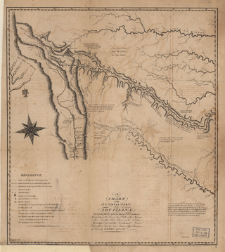
The Colonial history of Missouri covers the French and Spanish exploration and colonization: 1673–1803, and ends with the American takeover through the Louisiana Purchase

Three Forks Oklahoma is an imprecisely defined area of what is now eastern Oklahoma, around the confluence of the Arkansas, Verdigris, and Grand Rivers. The term, "Three Forks," was apparently used to designate this area as early as 1719, when the French trader Bernard de la Harpe traveled through the area, meeting and trading with members of the Wichita tribe at a place on the Arkansas River immediately south of the present city of Tulsa.

Benito Andres Vázquez, was a Spanish soldier and later, became an American fur trader who, while living on the western frontier, became a merchant and explorer. He is the father of fur trader Louis Vasquez.

<span class="mw-page-title-main">Joseph Bijeau</span> American fur trapper

Joseph Bijeau, also known as Joseph Bijeau dit Bissonet and Joseph Bissonet, was among the earliest fur trappers of the Rocky Mountains. He was a guide for Stephen Harriman Long's expedition of the Great Plains in 1820. A fur trapper and hunter, he lived among the Pawnee people. He was able to communicate to a number of Native American tribes through his use of sign language as well as the Crow language, which was used among a number of western tribes. After Spain lost the Mexican territory, trappers like Bijeau moved to Taos where they could trap, trade, and travel east without the hostilities that they experienced in the western United States.

References

38°02′13″N94°12′40″W / 38.0370052°N 94.2111969°W / 38.0370052; -94.2111969