Related Research Articles

Highland County is a county located in the Commonwealth of Virginia. As of the 2010 census, the population was 2,321, in 2018, the population was estimated at 2,210. Its county seat is Monterey. Known as "Virginia's Switzerland" or "Virginia's Little Switzerland", Highland County is the least populous county in Virginia. Highland lays claim to being one of the least populous counties and one of the highest average elevations east of the Mississippi River.
Covington is an independent city in the Commonwealth of Virginia. As of the 2010 census, the population was 5,961, making it the third-least populous city in Virginia. It is surrounded by Alleghany County, of which it is also the county seat. Located at the confluence of Jackson River and Dunlap Creek, Covington is one of three cities in the Roanoke Regional Partnership. The Bureau of Economic Analysis combines the city of Covington with Alleghany county for statistical purposes.

Botetourt County is a US county that lies in the Roanoke Region of the Commonwealth of Virginia. Located in the mountainous portion of the state, the county is bordered by two major ranges, the Blue Ridge Mountains and the Appalachian Mountains.

Alleghany County is an American county located on the far western edge of Commonwealth of Virginia. It is bordered by the Allegheny Mountains, from which the county derives its name, and it is the northernmost part of the Roanoke Region. The county seat is Covington.
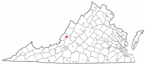
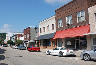
Low Moor is a census-designated place (CDP) in Alleghany County, Virginia. The population was 258 at the 2010 census.

Fort Machault was a fort built by the French in 1754 near the confluence of French Creek with the Allegheny River, at present-day Franklin, in northwest Pennsylvania. The fort was part of a line that included Fort Presque Isle, Fort Le Boeuf, and Fort Duquesne.
The AA Blue Ridge District is a district in the Region III of the Virginia High School League. The district is named for the Blue Ridge Mountains, which are nearby all of the schools.

Alleghany High School is a public secondary school in Alleghany County, VA, United States. It is part of Alleghany County Public Schools and is located at 210 Mountaineer Drive. Though the school has a Covington mailing address, it is actually about four miles east of Covington City, about two miles west of Low Moor, and roughly 9 miles from Clifton Forge
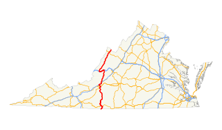
In the U.S. state of Virginia, U.S. Route 220 (US 220) is a major north-south state highway that extends from the North Carolina state line through Roanoke to the West Virginia state line. South of Roanoke, US 220 is a four-lane highway within the proposed Interstate 73 (I-73) corridor. US 220 narrows to two lanes north of Roanoke, connecting to I-64 near Clifton Forge and then paralleling the Appalachian Mountains north-northeasterly in the direction of Cumberland, Maryland.

State Route 18 is a primary state highway in the U.S. state of Virginia. Known for most of its length as Potts Creek Road, the state highway runs 25.86 miles (41.62 km) from SR 311 in Paint Bank north to U.S. Route 60 and US 220 in Covington.

State Route 154 is a primary state highway in the U.S. state of Virginia. The state highway runs 1.92 miles (3.09 km) over two sections within the independent city of Covington. SR 154's 1.31-mile (2.11 km) southern section connects Interstate 64 (I-64) with Locust Street. The 0.61-mile (0.98 km) northern segment connects Lexington Avenue with U.S. Route 60 and US 220.
Rayon Terrace is an unincorporated community in Alleghany County, Virginia, United States.

Potts Creek is a 46-mile-long (74 km) tributary of the Jackson River in western Virginia. Via the Jackson River, it is part of the James River watershed, flowing to Chesapeake Bay. The creek rises in Monroe County, West Virginia, south of Waiteville, and flows northeast through Craig County and Alleghany County in Virginia, joining the Jackson River at Covington.

Carpenter Creek in western Virginia, now known as Potts Creek, was shown on a map of the area drawn by Joshua Fry and Peter Jefferson in 1751 and printed in 1755, and so called in the text of Thomas Jefferson's "Notes on the State of Virginia" that he prepared in the 1780s. Carpenter's Creek is also shown as such on John Ballendine's map of the James River published c1772 and Thomas Hutchins' map of the western regions of Virginia published in 1778.
Dunlap Creek is a 25.9-mile-long (41.7 km) tributary of the Jackson River in the U.S. state of Virginia. It is part of the James River watershed.
Carpenter Mountain is located in Alleghany County, Virginia.
Carpenter's Battery, also known as Alleghany Artillery or Alleghany Rough Artillery, was a famed Confederate artillery battery unit in the American Civil War. The unit was first organized at Covington, Virginia on April 20, 1861 as Company A of the 27th Virginia Infantry Regiment, the "Alleghany Roughs." When the Captain who organized the company resigned due to ill health, the captaincy devolved upon his First Lieutenant, Joseph Hannah Carpenter, who was born in 1834 at Covington, Virginia, in Alleghany County, Virginia. Carpenter had been an artillery cadet under General Thomas J. "Stonewall" Jackson in the class of 1858 at Virginia Military Institute and legend has it that General Jackson recognized his former student's name on the company muster roll and ordered the company converted to an artillery battery with Carpenter as its captain, thus becoming "Carpenter's Battery."
Kate's Mountain, south of White Sulphur Springs in Greenbrier County, West Virginia, was named for Catherine "Kate" Carpenter, who in September 1756 took refuge with her child on the mountain's peak during an Indian attack in which her husband Nicholas Carpenter was killed near Fort Dinwiddie in the vicinity of White Sulphur Springs, West Virginia. Kate's Mountain is the highest of the peaks in Greenbrier State Forest at 3,280 feet. Kate's Mountain was the inspiration for the 19th Century romantic poem The Mystic Circle of Kate's Mountain, first published in fragmentary form in 1860 and published in its entirety in 1895. Kate's Mountain is the type location for Kate's Mountain Clover, Trifolium virginicum J.K. Small, 1892, the symbol of the West Virginia Native Plant Society.
Catherine "Kate" Carpenter, born probably ca. 1730s, died 1784, was a frontier wife and mother for whom Kate's Mountain in Greenbrier County, West Virginia is named.
Fort Dinwiddie (1755–1789) was a base for the Virginia Militia during the French and Indian War and Revolutionary War. It was located on the Jackson River, five miles west of Warm Springs, Virginia, in present-day Bath County.
References
- ↑ Alleghany County High School Students: Alleghany County: Yesterday, Today and Tomorrow, Jackson River Vocational Center, Covington, Va., 1976, pp. 41, 45.
- 1 2 Alleghany County High School Students, pp. 41, 45.
- ↑ City of Covington, Virginia: City of Covington Comprehensive Plan, http://www.covington.va.us/pdf/Comprehensive%20Plan/Covingtoncompplan.pdf, September 10, 2002, pp. 7-8.
- ↑ Alleghany Historical Society: Alleghany Comprehensive Plan 2007, http://www.rvarc.org/alleghany/History.pdf, draft dated 27 February 2007, p. 1.
- ↑ Carpenter, Mary Evelyn Harlow (1949). History of the Carpenters of "Fort Carpenter" 1746-1949. Allen County Public Library Genealogy Center. [n.p.] 1949.
Coordinates: 37°45′00″N79°59′21″W / 37.7499°N 79.9892°W
| | This article relating to the history of the United States is a stub. You can help Wikipedia by expanding it. |