Adams County is a county located in the U.S. state of Mississippi. As of the 2020 census, the population was 29,538. The county seat is Natchez. The county is the first to have been organized in the former Mississippi Territory. It is named for the second President of the United States, John Adams, who held that office when the county was organized in 1799. Adams County is part of the Natchez micropolitan area which consists of Adams County, Mississippi and Concordia Parish, Louisiana.

Henry Dearborn was an American military officer and politician. In the Revolutionary War, he served under Benedict Arnold in his expedition to Quebec, of which his journal provides an important record. After being captured and exchanged, he served in George Washington's Continental Army. He was present at the British surrender at Yorktown. Dearborn served on General George Washington's staff in Virginia.

The Natchez Trace, also known as the Old Natchez Trace, is a historic forest trail within the United States which extends roughly 440 miles (710 km) from Nashville, Tennessee, to Natchez, Mississippi, linking the Cumberland, Tennessee, and Mississippi rivers.

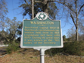
Washington is an unincorporated community in Adams County, Mississippi, United States. Located along the lower Mississippi, 6 miles (9.7 km) east of Natchez, it was the second and longest-serving capital of the Mississippi Territory.

Douglas Hancock Cooper was an American politician, soldier, Indian Agent in what is now Oklahoma, and Confederate general during the American Civil War.

Samuel Ross Mason, also spelled Meason, was a Virginia militia captain, on the American western frontier, during the American Revolutionary War. After the war, he became the leader of the Mason Gang, a criminal gang of river pirates and highwaymen on the lower Ohio River and the Mississippi River in the late 18th and early 19th centuries. He was associated with outlaws around Red Banks, Cave-in-Rock, Stack Island, and the Natchez Trace.

Fort Rosalie was built by the French in 1716 within the territory of the Natchez Native Americans as part of the French colonial empire in the present-day city of Natchez, Mississippi.

William Dunbar was a Scottish-born American merchant, plantation owner, naturalist, astronomer and explorer.

Rodney is a ghost town in Jefferson County, Mississippi, United States. Most of the buildings are gone and the remaining structures are in various states of disrepair. The town regularly floods and buildings have extensive flood damage. The Rodney History And Preservation Society is restoring Rodney Presbyterian Church, whose damaged facade from the American Civil War that includes a replica cannonball embedded above its balcony windows, has been maintained as part of the historical preservation. The Rodney Center Historic District is on the National Register of Historic Places.
Ferdinand Leigh Claiborne was an American military officer most notable for his command of the militia of the Mississippi Territory during the Creek War and the War of 1812.

Coon Box, also Coonbox and Raccoon Box, is a placename in Jefferson County, Mississippi, United States. Coon Box is 5.9 miles (9.5 km) north of Fayette. The Coon Box Fork Bridge, which is listed on the National Register of Historic Places, is located one mile southwest of Coon Box.

Selsertown is a ghost town in Adams County, Mississippi, United States.

Bruinsburg is an extinct settlement in Claiborne County, Mississippi, United States. Founded when the Natchez District was part of West Florida, the settlement was one of the end points of the Natchez Trace land route from Nashville to the lower Mississippi River valley.

Uniontown is a ghost town in Jefferson County, Mississippi, United States.
Ephraim Geoffrey Peyton was an American jurist, lawyer, and politician. He was judge of the High Court of Errors and Appeals of Mississippi from 1868 to 1870 and a justice of its successor, the Mississippi Supreme Court, from 1870 to 1876 including as chief justice.

Old Greenville is a ghost town in Jefferson County, Mississippi, United States. The town was located along the old Natchez Trace and was once the largest town along the Trace. Nothing exists at the site today except the town's cemetery.

The Natchez slave market was a slave market in Natchez, Mississippi in the United States. Slaves were originally sold throughout the area, including along the Natchez Trace that connected the settlement with Nashville, along the Mississippi River at Natchez-Under-the-Hill, and throughout town. From 1833 to 1863, the Forks of the Road slave market was located about a mile from downtown Natchez at the intersection of Liberty Road and Washington Road, which has since been renamed to D'Evereux Drive in one direction and St. Catherine Street in the other. The market differed from many other slave sellers of the day by offering individuals on a first-come first-serve basis rather than selling them at auction, either singly or in lots. At one time the Forks of the Road was the second-largest slave market in the United States, trailing only New Orleans.

Petit Gulf was a location on the Mississippi River in North America. The gulf was an eddy or whirlpool that was smaller than the nearby Grand Gulf. The eddy lent its name to the nearby Petit Gulf Hills and Petit Gulf Creek. There was a settlement there prior to the 1828 organization of Rodney, Mississippi, and the Petit Gulf cotton cultivar, which was widely planted in the U.S. South before the American Civil War, was named for the landing and town.

Peter Bryan Bruin was a landowner and judge in Mississippi Territory, United States. A veteran of the American Revolutionary War who served as an officer with Daniel Morgan and worked as an aide-de-camp to John Sullivan, he settled in the Natchez District shortly after the conclusion of the American revolution. He was later a host to a young Andrew Jackson and Rachel Donelson Robards, on what may have amounted to their honeymoon circa 1790. In 1798 Bruin was signatory to the "Memorial to Congress by Permanent Committee of the Natchez District," which encouraged the U.S. Congress to annex the Natchez District from Spain and to preserve and extend slavery in the region. After the Mississippi Territory was organized, he was appointed to be a judge by John Adams. Bruin was tangentially connected to Aaron Burr's still-mysterious shenanigans in the lower Mississippi River valley in 1806. In 1808, the Mississippi Territorial Legislature passed a resolution condemning Bruin's conduct on the bench, and delegate George Poindexter requested that the U.S. Congress open an impeachment investigation into Bruin. Bruin resigned his judgeship amidst public charges of alcoholism and dereliction of judicial duty.

Fort Nogales was a 18th-century Spanish colonial fort in West Florida, at the confluence of the Yazoo River and the Mississippi River. The fort stood at the site of present-day Vicksburg, Warren County, Mississippi, United States.


