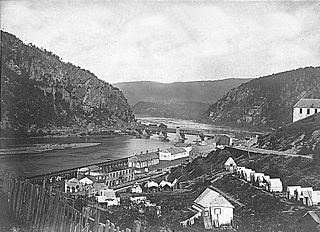
The Battle of Harpers Ferry was fought September 12–15, 1862, as part of the Maryland Campaign of the American Civil War. As Confederate Army General Robert E. Lee's Confederate army invaded Maryland, a portion of his army under Major General Thomas J. "Stonewall" Jackson surrounded, bombarded, and captured the Union garrison at Harpers Ferry, Virginia.

Fort Pickens is a pentagonal historic United States military fort on Santa Rosa Island in the Pensacola, Florida, area. It is named after American Revolutionary War hero Andrew Pickens. It is the largest of four forts built to defend Pensacola Bay and its navy yard. The fort was completed in 1834 and was one of the few forts in the South that remained in Union hands throughout the American Civil War. It remained in use until 1947. Fort Pickens is included within the Gulf Islands National Seashore, and as such, is administered by the National Park Service.

The Battle of Ball's Bluff was an early battle of the American Civil War fought in Loudoun County, Virginia, on October 21, 1861, in which Union Army forces under Major General George B. McClellan suffered a humiliating defeat.

Fort Monroe is a former military installation in Hampton, Virginia, at Old Point Comfort, the southern tip of the Virginia Peninsula, United States. It is currently managed by partnership between the Fort Monroe Authority for the Commonwealth of Virginia, the National Park Service, and the city of Hampton as the Fort Monroe National Monument. Along with Fort Wool, Fort Monroe originally guarded the navigation channel between the Chesapeake Bay and Hampton Roads—the natural roadstead at the confluence of the Elizabeth, the Nansemond and the James rivers.
Neersville is an unincorporated community in northwestern Loudoun County, Virginia, United States. It is located in the Between the Hills area of the Loudoun Valley on Harpers Ferry Road at the foot of Short Hill Mountain. It is notable for being the birthplace of Confederate guerrilla John Mobberly.
The Battle of Mile Hill was a cavalry skirmish during the American Civil War, that took place just north of Leesburg, Virginia, on September 2, 1862. It preceded the occupation of the town by the Army of Northern Virginia just prior to its crossing of the Potomac River starting the Maryland Campaign.
Loudoun County, Virginia, was destined to be an area of significant military activity during the American Civil War. Located on Virginia's northern frontier, the Potomac River, Loudoun County became a borderland after Virginia's secession from the Union in early 1861. Loudoun County's numerous Potomac bridges, ferries and fords made it an ideal location for the Union and Confederate armies to cross into and out of Virginia. Likewise, the county's several gaps in the Blue Ridge Mountains that connected the Piedmont to the Shenandoah Valley and Winchester were of considerable strategic importance. The opposing armies would traverse the county several times throughout the war leading to several small battles, most notably the Battle of Ball's Bluff.

Fort Reynolds was a Union Army redoubt built as part of the defenses of Washington, D.C., in the American Civil War.
The city of Winchester, Virginia, and the surrounding area, were the site of numerous battles during the American Civil War, as contending armies strove to control the lower Shenandoah Valley. Winchester changed hands more often than any other Confederate city.
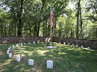
Ball's Bluff Battlefield Regional Park and National Cemetery is a battlefield area and a United States National Cemetery, located 2 miles (3.2 km) northeast of Leesburg, Virginia. The cemetery is the third smallest national cemetery in the United States. Fifty-four Union Army dead from the Battle of Ball's Bluff are interred in 25 graves in the half-acre plot; the identity of all of the interred except for one, James Allen of the 15th Massachusetts, are unknown. Monuments to fallen Confederate Sergeant Clinton Hatcher and Union brigade commander Edward Dickinson Baker are located next to the cemetery, though neither is buried there. While the stone wall-enclosed cemetery itself is managed through the Culpeper National Cemetery and owned by the Department of Veterans Affairs, the balance of the 223-acre (0.90 km2) park is managed through the Northern Virginia Regional Park Authority.

The 35th Virginia Cavalry Battalion, also known as White's Battalion, White's Rebels and the Comanches, was a Confederate cavalry unit during the American Civil War raised by Elijah V. White in Loudoun County, Virginia in the winter of 1861-62. The battalion was initially raised as border guards along the Potomac River below Harpers Ferry but were ultimately mustered into regular service as part of the Laurel Brigade. Despite this, they continued to play a conspicuous role in the ongoing partisan warfare in Loudoun throughout the war. The battalion was particularly notable during the 1863 Gettysburg Campaign, when it played a prominent role in the Battle of Brandy Station and subsequently conducted a series of raids on Union-held railroads and defensive positions in Maryland and Pennsylvania. The 35th was the first Confederate unit to enter Gettysburg, Pennsylvania.
Fort Johnston, also known as Fort Geary, is a Civil War era earthen fort atop a 670 feet (200 m) peak of Catoctin Mountain just west of Leesburg, Virginia. Constructed in the winter of 1861-62 following the Battle of Ball's Bluff, it is one of three forts constructed to defend the town from the threat of possible invasion. The fort was built in the design of a four-point star with arm of each point measuring roughly 110 feet (34 m) in length. The fort was only sporadically occupied by Confederates, as the main threat of invasion came from the east across the Potomac. In 1862, when Loudoun County was invaded by the Union army, the fort was abandoned and later occupied by the Federals who rechristened it Fort Geary in honor of their commander. Throughout the war, Leesburg was rarely held in force by either side of the conflict and the fort saw little use. Today, parts of the earthworks of the fort still exist, and are located on private property on Fort Johnston Road.
The 8th Virginia Infantry Regiment was a Confederate infantry regiment raised by Colonel Eppa Hunton in Leesburg, Virginia on May 8, 1861. The unit comprised six companies from Loudoun, two companies from Fauquier, one company from Fairfax and one company from Prince William. Initial regimental officers included: Lt. Colonel Charles B. Tebbs, Major Norborne Berkeley, John M. Orr - Quartermaster, Dr. Richard H. Edwards - Surgeon, Charles F. Linthicum - Chaplain. After Eppa Hunton's promotion to brigadier general in August 1863, in part based on his valor during the Battle of Gettysburg, particularly during Pickett's Charge, Norborne Berkeley was promoted to command the 8th Virginia, and his brother Edmund became the Lieut. Colonel, his brother William Berkeley, Major, and Charles Berkeley became the senior Captain of what then became known as the "Berkeley Regiment." Nonetheless, Norborne, William and Charles Berkeley were all in Union prisoner of war camps and their brother Edmund still recovering from his Gettysburg wound on August 9.

Built by Confederate Lieutenant Collier and Virginia militia with the aid of Federal prisoners, the Fort Collier redoubt guarded the north entrance of Winchester, Virginia on the east side of the Martinsburg Pike. During later Federal occupations, it was known as Battery No. 10. The fort was set on low ground, and generally offered little military advantage, except as a guard post for the pike. Lieutenant General Jubal Early used it as part of his defensive works in the Third Battle of Winchester.

Fort Ellsworth was a timber and earthwork fortification constructed west of Alexandria, Virginia, as part of the defenses of Washington, D.C. during the American Civil War. Built in the weeks following the Union defeat at Bull Run, Fort Ellsworth was situated on a hill north of Hunting Creek, and Cameron Run,. From its position on one of the highest points west of Alexandria, the fort overlooked the Orange and Alexandria Railroad, the Little River Turnpike, and the southern approaches to the city of Alexandria, the largest settlement in Union-occupied Northern Virginia.
Fort Beauregard was a Civil War-era rectangular earthen fort located on a 430 feet (130 m) promontory above Tuscarora Creek just southeast of Leesburg, Virginia. Built in the winter of 1861–1862 following the Battle of Ball's Bluff, it was one of three forts built by Confederates to defend Leesburg against possible invasion. Fort Beauregard commanded the southern eastern approaches to the town, including the Old Carolina Road and the Alexandria and Winchester Turnpike. The fort may have been only partially constructed, and was never occupied by Confederates in force before Leesburg was evacuated in the spring of 1862. The fort was occupied by Union forces for a brief period in the summer of 1862. The fort was subsequently destroyed, and the exact location remains unknown. The likely site currently sits in the privately owned "Beauregard Estates" neighborhood.

1st Maryland Cavalry Battalion, Potomac Home Brigade, originally organized as the 1st Potomac Home Brigade Cavalry, "Cole's Cavalry" was formed under the guidance of Henry A. Cole. There are also references to it being designated as Cole's 1st Volunteer Maryland Cavalry. The unit, a battalion, originally consisted of four companies, A, B, C & D and was initially enlisted between August 10 and November 27, 1861.
The following Confederate States Army units and commanders fought in the Battle of Ball's Bluff of the American Civil War, fought from October 20 to October 24, 1861 in Loudoun County, Virginia, also known as the Battle of Leesburg or the Battle of Harrison's Island. The Union order of battle is shown separately.
James Harvey Carson was a brigadier general in the Virginia militia, who served along with the Confederate States Army in northwestern Virginia at various times during 1861 and early 1862 in the American Civil War. Carson's men were part of Stonewall Jackson's force that moved to take the town of Bath, later Berkeley Springs, now in West Virginia, on January 3, 1862.

Fort Norfolk is a historic fort and national historic district located at Norfolk, Virginia. With the original buildings having been built between 1795 and 1809, the fort encloses 11 buildings: main gate, guardhouse, officers' quarters, powder magazine, and carpenter's shop. Fort Norfolk is the last remaining fortification of President George Washington's 18th century harbor defenses, later termed the first system of US fortifications. It has served as the district office for the U.S. Army Engineer District, Norfolk since 1923.

