Mahim (Marathi: माहिम) is a neighbourhood in Mumbai, Maharashtra, India. The Mahim Junction railway station on the Western Railway and Harbour Railway of the Mumbai Suburban Railway network is the last station of the city, as neighboring Bandra comes in Mumbai Suburb. Mahim is an ethnically and religiously diverse town and has a Hindu temple, church, mosque and Parsi fire-temple existing within a few meters of each other. The town has a large Rich and Upper Middle class Marathi population.

Vasai, is a historical place and City near Mumbai (Bombay)'s western suburbs, located in Palghar district which was partitioned from the Thane district in 2014. It also forms a part of Vasai-Virar twin cities in the Konkan division of Maharashtra, India.

Although the tanks have long vanished, the city of Bombay once had many water tanks within its city limits. They were once the only source of water to the city. The only testimony to their existence is the names of the roads in their vicinity, which befuddles many citizens as to the original location to these mystifying relics of the past.

Gorai ([ɡoɾaːi]) is a village at Dharavi Bhet, in Mumbai, India. It is located on the North-western part of the island of Salsette. Gorai is accessed more usually by a ferry crossing the Manori Creek and Gorai creek or otherwise by the overland route through Bhayander. Gorai is bordered by the villages of Manori and Uttan, Pali, Chowk, Dongri, Tarodi, Rai, Morva and Murdhe.

The East Indians, also called East Indian Catholics or Bombay East Indians, are an ethno-religious Indian Christian community native to the Seven Islands of Bombay and the neighbouring Mumbai Metropolitan Region of the Konkan division.

Fort is a business and art district in the city of Mumbai, Maharashtra. The area gets its name from the defensive fort, Fort George, built by the British East India Company around Bombay Castle.

The Sewri Fort is a fort in Mumbai built by the British at Sewri. Built in 1680, fort served as a watch tower, atop a quarried hill overlooking the Mumbai harbour.

The Dongri Fort or the Dongri Hill Fort, locally known as the Janjire Dhavari Fort, is a fort in Mumbai, India. It is located in the Dongri area. It came under Maratha rule in 1739. Since then the locals and the church have been looking after the maintenance of the Fort, which was once repaired. Every year, during the month of October, the feast of Our Lady of Fatima is celebrated there. Many People from far off villages come to offer their prayers there. One can take a 360 degree view of the surroundings from this fort, with the Arabian sea at the West, the Vasai Fort at the North, the Borivali National Park at the East, and the Essel World and Water Kingdom at the South.

The Battle of Vasai or the Battle of Bassein was fought between the Marathas and the Portuguese rulers of Vasai, a town lying near Mumbai (Bombay) in the Konkan region of present-day state of Maharashtra, India. The Marathas were led by Chimaji Appa, a brother of Peshwa Baji Rao I.

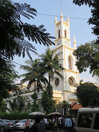
St. Thomas Cathedral, Mumbai, is the 300-year old cathedral church of the Diocese of Mumbai of the Church of North India. It is named in honour of Saint Thomas the Apostle, who is believed to have first brought Christianity to India. The cathedral is located in Horniman Circle, the historic centre of Mumbai. It is in close proximity to famous Mumbai landmarks such as Flora Fountain and Bombay House. It is the oldest church in Mumbai The Cathedral and John Connon School is run by the cathedral.

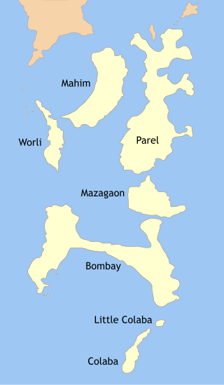
Isle of Bombay was one of the Seven Islands of Bombay, an archipelago of islands that were, in the eighteenth century, connected to form the area of the modern city of Bombay in India. The island was the main harbour and the Base of the British from where the city expanded.

Sandhurst Road is a railway station serving Dongri area of South Mumbai, India, on the Central and Harbour Lines of the Mumbai Suburban Railway. It is the third stop from Chhatrapati Shivaji Maharaj Terminus.

Suvarnadurg is a fort that is located between Mumbai and Goa on a small island in the Arabian Sea, near Harnai in Konkan, along the West Coast of India, in the Indian state of Maharashtra. The fort also includes another small land fort called the Kanakadurga at the base of headland of Harnai port on the coast. Building of the fort is credited to Chhatrapati Shivaji Maharaj, founder of the Maratha Empire, in 1660. Subsequently, ChatrapatiShivaji Maharaj, other ttraPeshwas and the Angres further fortified the forts for defence purposes.

Kolaba Fort located at Alibag beach is an old fortified maritime base in Alibag, Konkan, India. It is situated in the sea at a distance of 1–2 km from the shores of Alibag, 35 km south of Mumbai, in the Konkan region of Maharashtra, India. It is a popular tourist destination and a protected monument.
Dongri is a port city in the Mira-Bhayandar municipality of Thane district, situated just north of Gorai, Mumbai. The word 'Dungaree' has its origin in Dongri due to this genre of garment monolithically being manufactured from textile sectors within the confines of the city.
Indigenous tribals have inhabited Mumbai (Bombay) since the Stone Age. The Kolis and Aagri were the earliest known settlers of the islands. The Maurya Empire gained control of the islands during the 3rd century BCE and transformed them into a centre of Hindu-Buddhist culture and religion. Later, between the 2nd century BCE and 10th century CE, the islands came under the control of successive indigenous dynasties: the Satavahanas, Abhiras, Vakatakas, Kalachuris, Konkan Mauryas, Chalukyas, Rashtrakutas, Silharas& Cholas.
Mendham's Point is a locality near the present day Lion Gate at Colaba in Mumbai. Until 1760, the English buried their dead at Mendham's Point. Gerald Aungier, Governor of Bombay, had planned extensive fortifications for Bombay from Dongri in the north to Mendham's Point in the south.
Underi is a fortified island near the mouth of Mumbai harbour south of Prong's Lighthouse. It is a companion fort to Khanderi and currently lies in Raigad district, Maharashtra. These islands of Khanderi and Underi served as one of the landmarks for ships entering Mumbai harbour. Underi is smaller than Khanderi.
Dongri jail is a British era jail on Jail road, Dongri, an area in Mumbai, India. It played an important role in the Indian freedom movement, as it played host to a number of under-trial freedom fighters like Bal Gangadhar Tilak, Savarkar and Agarkar.


