Fort (Mumbai precinct)

Last updated

Fort
Fort District
Neighborhood
Mumbai fort remains 6.jpg
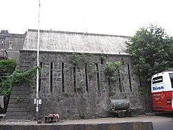
Remains of the Fort George walls
Mumbai area locator map.svg
Red pog.svg
Fort
Coordinates: 18°56′06″N72°50′09″E / 18.935°N 72.8359°E / 18.935; 72.8359
CountryIndia
State Maharashtra
District Mumbai City
Metro Mumbai
Zone1
WardA
Government
  Type Municipal corporation
  Body Brihanmumbai Municipal Corporation (MCGM)
Elevation
11 m (36 ft)
Languages
  Official Marathi,
Time zone UTC+5:30 (IST)
PIN
400 001
Lok Sabha constituencyMumbai South
Civic agency BMC

Fort is a business and art district in the city of Mumbai, Maharashtra, India. The area gets its name from the defensive fort, Fort George, built by the British East India Company around Bombay Castle.

Contents

The area extends from the docks in the east, to Azad Maidan in the west; Chhatrapati Shivaji Maharaj Terminus in the north to Kala Ghoda in the south. This area is the heart of the financial markets of the city & multiple British era structures are located in this neighbourhood.

History

Map of Bombay Fort, 1771 Bombay fort.jpg
Map of Bombay Fort, 1771

The Fort area was declared protected under regulations of the Maharashtra Government Urban Development Department. An advisory committee now oversees the development, repairs and renovations of structures in the precinct. In 1882, Bomanjee Hormarjee Wadia Clock Tower was erected using public funds as a token of appreciation for Bomanjee Hormarjee, a Parsi philanthropist who made contributions towards improving education in Bombay. The Fort neighbourhood of Mumbai was the first part to be developed by the British. Then, over the years it stood as a reminder of India's rich colonial history, and today it is sort of a jewel in the crown of the city's cultural scene. [1]

It had been listed as a notorious market in 2009 and 2010 by the USTR for selling counterfeit software, media and goods. [2] [3]

See also

Related Research Articles

<span class="mw-page-title-main">Mumbai</span> Capital of Maharashtra, India

Mumbai is the capital city of the Indian state of Maharashtra. Mumbai is the de facto financial centre and the most populous city of India with an estimated city proper population of 12.5 million (1.25 crore). Mumbai is the centre of the Mumbai Metropolitan Region, the sixth most populous metropolitan area in the world with a population of over 23 million living within the Mumbai Metropolitan Region. Mumbai lies on the Konkan coast on the west coast of India and has a deep natural harbour. In 2008, Mumbai was named an alpha world city.

<span class="mw-page-title-main">Maharashtra</span> State in western India

Maharashtra is a state in the western peninsular region of India occupying a substantial portion of the Deccan Plateau. It is bordered by the Arabian Sea to the west, the Indian states of Karnataka and Goa to the south, Telangana to the southeast and Chhattisgarh to the east, Gujarat and Madhya Pradesh to the north, and the Indian union territory of Dadra and Nagar Haveli and Daman and Diu to the northwest. Maharashtra is the second-most populous state in India and the fourth-most populous country subdivision globally.

<span class="mw-page-title-main">Bandra</span> Suburb of Mumbai, India

Bandra ([bæːɳɖɾa]) is a coastal suburb located in Mumbai, the largest city of the Konkan division in Maharashtra, India. The area is located to the immediate north of the River Mithi, which separates Bandra from the Mumbai City district. It is the third-largest commercial hub in Maharashtra, after the Bombay city district and Pune, primarily aided by the Bandra-Kurla Complex.

<span class="mw-page-title-main">Mumbai Police</span> Indian police department

The Mumbai Police is the police department of the city of Mumbai, Maharashtra. It is a part of Maharashtra Police and has the primary responsibilities of law enforcement and investigation within the limits of Mumbai. The force's motto is "Sadrakṣaṇāya Khalanigrahaṇāya".

<span class="mw-page-title-main">Kurla</span> Suburb in Mumbai Suburban, Maharashtra, India

Kurla is a suburb of East Mumbai, India. It is the headquarters of the Kurla taluka of Mumbai Suburban district. The neighbourhood is named after the eponymous East Indian village that it grew out of. It falls under Zone 5, Ward 'L' of the Bombay Municipal Corporation. Its railway station, spelt as Coorla until 1890, is one of the busiest on the Mumbai suburban railway on the central and harbour railway lines of Mumbai as is the Lokmanya Tilak Terminus (LTT) for out-station passenger/express trains.

<span class="mw-page-title-main">Flora Fountain</span> Heritage monument in Mumbai, India

Flora Fountain is a Fountain located at the Hutatma Chowk is an ornamentally sculpted architectural heritage monument located at the southern end of the historic Dadabhai Naoroji Road, at the Fort business district in the heart of South Mumbai, Mumbai, India. Flora Fountain, built in 1864, depicts the Roman goddess Flora. It was built at a total cost of Rs. 47,000, or 9,000 pounds sterling, a large sum in those days.

<span class="mw-page-title-main">Salsette Island</span> Island off the coast of Maharashtra, India

Salsette Island is an island in Konkan division of the state of Maharashtra, on India's west coast. Administratively known as Greater Mumbai, the city district of Mumbai, Mumbai Suburban district, Mira Bhayander, and a portion of Thane lie within it, making it very populous and one of the most densely populated islands in the world. It has a population of more than 20 million inhabitants living on an area of about 619 square kilometres (239 sq mi).

<span class="mw-page-title-main">Madh Island</span> Village in Maharashtra

Madh Island is a group of several quaint fishing villages and farmlands in northern Mumbai.

<span class="mw-page-title-main">Fort Vasai</span> Fort in Vasai, Maharashtra, India

Fort Vasai is a ruined fort of the town of Vasai (Bassein), Palghar, Maharashtra, India. The structure was formally christened as the Fort of St. Sebastian in the Indo-Portuguese era. The fort is a monument of national importance and is protected by the Archaeological Survey of India.

<span class="mw-page-title-main">Sion Hillock Fort</span> Fort in Mumbai (Bombay), India

The Sion Hillock Fort is a fort in Mumbai (Bombay), India. It was built under the regime of the English East India Company, between 1669 and 1677, atop a conical hillock when Gerard Aungier was the Governor of Bombay. It was notified in 1925 as a Grade I Heritage structure. When it was built, the fort marked the boundary between British-held Parel island and the Portuguese held Salsette Island that lay to the north across the creek.

<span class="mw-page-title-main">Pune district</span> District in Maharashtra, India

Pune district is a district in Western Maharashtra with Administrative Headquarters in Pune city. Pune district is the most populous district in the Indian state of Maharashtra. It is one of the most industrialised districts in India.

<span class="mw-page-title-main">Lamington Road</span> Thoroughfare in Mumbai, India

Lamington Road, officially Dr. Dadasaheb Bhadkamkar Marg, named after Lord Lamington, the Governor of Bombay between 1903 and 1907, is a busy thoroughfare near Grant Road station in South Mumbai. The official name of the road is rarely used. It is often called the "IT shop of Mumbai".

<span class="mw-page-title-main">Bombay Castle</span> Fort in Bombay

Bombay Castle is one of the oldest defensive structures built in the city of Mumbai. The current castle is a structure built by the British on the site of the Manor House built by a Portuguese nobleman Garcia de Orta. Orta had leased the island of Bombay from the King of Portugal between 1554 and 1570.

<span class="mw-page-title-main">Belapur Fort</span> Medieval coastal fort near Mumbai

Belapur Fort is a fort near the township of Belapur in Navi Mumbai, Maharashtra, India. The fort was built by the Siddis of Janjira. It was later conquered by the Portuguese, and then Marathas. In the early 19th century, the fort was captured by the British. After the British gained supremacy in the region, with the expansion of the Bombay Presidency, the strategic importance of the fort declined, and it fell into disuse.

Colaba Causeway, officially known as Shahid Bhagat Singh Road, is a commercial street, and a major causeway or land link between Colaba and the Old Woman's Island in the city of Mumbai, India.

Chakan is a census town in India, in Pune district of the Indian state of Maharashtra. While agriculture remains an important factor, the town's industrial development is quickly urbanizing the area. The Independent referred Chakan as India's "Motor City".

<span class="mw-page-title-main">Economy of Maharashtra</span>

The economy of the state of Maharashtra is the largest in India. Mumbai, the capital of Maharashtra is considered the financial capital of India with the headquarters of almost all major banks, financial institutions, insurance companies and mutual funds being based in the city. India's largest stock exchange Bombay Stock Exchange, the oldest in Asia, is also located in the city. More than 41% of the S&P CNX 500 conglomerates have corporate offices in Maharashtra.

Indigenous tribals have inhabited Mumbai (Bombay) since the Stone Age. The Kolis and Aagri were the earliest known settlers of the islands. Between the 2nd century BCE and 10th century CE, the islands came under the control of successive indigenous dynasties: the Satavahanas, Abhiras, Vakatakas, Kalachuris, Konkan Mauryas, Chalukyas, Rashtrakutas, Silharas & Chollas.

<span class="mw-page-title-main">Dadabhai Naoroji Road</span> Road in South Mumbai, Maharashtra, India

Dadabhai Naoroji Road (D.N.Road), a North–South commercial artery road, in the Fort business district in South Mumbai of Maharashtra, India, is the nerve centre of the city, starting from the Mahatma Phule Market ,linking Chhatrapati Shivaji Maharaj Terminus, leads to the Hutatma Chowk at the southern end of the road. This entire stretch of the road is studded with Neo–Classical and Gothic Revival buildings and parks built in the 19th century, intermingled with modern office buildings and commercial establishments.

<span class="mw-page-title-main">Bomanjee Hormarjee Wadia Clock Tower</span> Clock tower in Mumbai, India

Bomanjee Hormarjee Wadia Clock Tower is a heritage structure in Fort, Mumbai, India, that was erected in 1882 using public funds as a token of appreciation for Bomanjee Hormarjee Wadi, a Parsi philanthropist who had contributed to the cause of education in the city. He was a member of the Bombay Native Education Society and on the board of Elphinstone Institution. He died on 3 July 1862.

References

  1. Chowdhury, Arka Roy. "A look into the Fort area of Mumbai". Times of India Travel.
  2. "Section 3"  . Special 301 Report via Wikisource.
  3. "Section 3"  . Special 301 Report via Wikisource.

See also