
Castillo San Felipe del Morro, most commonly known as El Morro(The Promontory), is a large fortress and citadel in the historic district of Old San Juan in Puerto Rico. Commissioned by King Charles I of Spain in 1539, it was first built as a fortified tower in honor of King Philip II, who oversaw its expansion into a hornwork fort by 1595. Over the next 200 years, especially in the reign of King Charles III, El Morro continued to be developed to reach its current form in 1787. Rising 140 ft from the Atlantic shoreline with 18 to 25 ft thick walls, the six-leveled edifice stands on a steep, rocky headland promontory on San Juan Islet guarding the entry to San Juan Bay, the harbor of Old San Juan. El Morro, alongside La Fortaleza, San Cristóbal, El Cañuelo, and other forts part of the Walls of Old San Juan, protected strategically and militarily important Puerto Rico, or La Llave de las Indias, from invasion by competing world powers during the Age of Sail. It was designated a World Heritage Site by UNESCO in 1983.

Fort Point, known historically as the Castillo de San Joaquín is a masonry seacoast fortification located on the southern side of the Golden Gate at the entrance to San Francisco Bay. It is also the geographic name of the promontory upon which the fort and the southern approach of the Golden Gate Bridge were constructed.
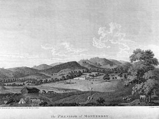
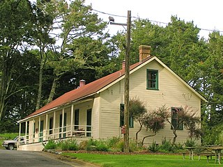
The Presidio of Monterey (POM), located in Monterey, California, is an active US Army installation with historic ties to the Spanish colonial era. Currently, it is the home of the Defense Language Institute Foreign Language Center (DLI-FLC). It is the last and only presidio in California to have an active military installation.

The second USS Cyane was a sloop-of-war in the United States Navy during the Mexican–American War.
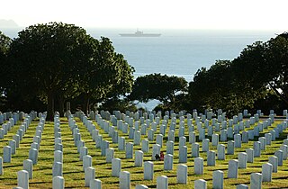
Fort Rosecrans National Cemetery is a federal military cemetery in San Diego, California. It is located on the grounds of the former Army coastal artillery station Fort Rosecrans and is administered by the United States Department of Veterans Affairs. Fort Rosecrans is named after William Starke Rosecrans, a Union general in the American Civil War.

State Route 209 (SR 209) was a state highway in the U.S. state of California, connecting Cabrillo National Monument with the interchange of Interstate 5 (I-5) and I-8 in San Diego, passing through the neighborhoods of Point Loma. The majority of the route was along Rosecrans Street; it also included Cañon Street and Catalina Boulevard leading to the tip of Point Loma.
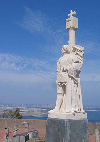
Cabrillo National Monument is a national monument at the southern tip of the Point Loma Peninsula in San Diego, California, United States. It commemorates the landing of Juan Rodríguez Cabrillo at San Diego Bay on September 28, 1542. This event marked the first time a European expedition had set foot on what later became the West Coast of the United States. The site was designated as California Historical Landmark #56 in 1932. The area was listed on the National Register of Historic Places on October 15, 1966.
William Edward Cleator Sr. was an American politician from San Diego, California. He served on the San Diego City Council for six years including five months as acting mayor of San Diego. He was a Republican, although city positions are officially nonpartisan per California state law.

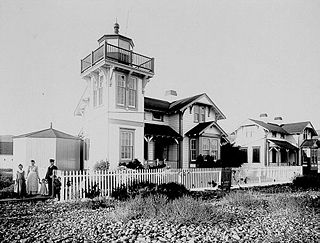
The original Point Loma Lighthouse is a historic lighthouse located on the Point Loma peninsula at the mouth of San Diego Bay in San Diego, California. It is situated within Cabrillo National Monument. It is no longer in operation as a lighthouse but is open to the public as a museum. It is sometimes erroneously called the "Old Spanish Lighthouse", but in fact it was not built during San Diego's Spanish or Mexican eras; it was built in 1855 by the United States government after California's admission as a state.
Ballast Point Lighthouse was a lighthouse in San Diego, California, situated on Ballast Point, a tiny peninsula extending into San Diego Bay from Point Loma. The lighthouse was torn down in 1960; the site is now on the grounds of Naval Base Point Loma. Ballast Point Lighthouse was the last lighthouse displaying a fixed light on the Pacific coast. An automated light is left in its place and operates on a piling in the water off of the original site.

Point Loma is a seaside community in San Diego, California, United States. Geographically it is a hilly peninsula that is bordered on the west and south by the Pacific Ocean, the east by San Diego Bay and Old Town, and the north by the San Diego River. Together with the Silver Strand/Coronado peninsula, the Point Loma peninsula defines San Diego Bay and separates it from the Pacific Ocean. The term "Point Loma" is used to describe both the neighborhood and the peninsula.
The Fort Miley Military Reservation, in San Francisco, California, sits on Point Lobos, one of the outer headlands on the southern side of the Golden Gate. Much of the site is part of the Golden Gate National Recreation Area, while the grounds and buildings that were converted into the San Francisco VA Medical Center are administered by the Veterans Health Administration of the US Department of Veterans Affairs.

Naval Base Point Loma (NBPL) is a United States Navy base in Point Loma, a neighborhood of San Diego, California. It was established on 1 October 1998 when Navy facilities in the Point Loma area of San Diego were consolidated under Commander, Navy Region Southwest. Naval Base Point Loma consists of seven facilities: Submarine Base, Naval Mine and Anti-Submarine Warfare Command, Fleet Combat Training Center Pacific, Naval Information Warfare Systems Command (NAVWAR), Naval Information Warfare Center Pacific, the Fleet Intelligence Command Pacific and Naval Consolidated Brig, Miramar. These close-knit commands form a diverse and highly technical hub of naval activity. The on-base population is around 22,000 Navy and civilian personnel.

Silver Strand Training Complex (SSTC) is a training facility for U.S. Special Operations Forces. Located between Imperial Beach and Silver Strand State Beach near San Diego. The area is part of Naval Base Coronado and commanded by that base's Commanding Officer. While just north of Imperial Beach, it is within the city limits of Coronado. The facility was known by locals as the "elephant cage" which is a nickname for the large Wullenweber direction finder antenna. The antenna was used to provide direction finding, primary communication links for U.S. Navy submarines. The antenna was finally dismantled in 2015, even though it was scheduled to be removed in fiscal year 2007.

The architecture of San Francisco is not so much known for defining a particular architectural style; rather, with its interesting and challenging variations in geography and topology and tumultuous history, San Francisco is known worldwide for its particularly eclectic mix of Victorian and modern architecture. Bay windows were identified as a defining characteristic of San Francisco architecture in a 2012 study that had a machine learning algorithm examine a random sample of 25,000 photos of cities from Google Street View.

Midway is a neighborhood in San Diego, California. It is located at the northern (mainland) end of the Point Loma peninsula, northwest of downtown San Diego, and just west of Old Town. It is often considered to be part of Point Loma, although the city treats it as a separate planning area.
La Playa is a bayfront neighborhood in the Point Loma community of San Diego, California. It is bordered by San Diego Bay to the east, Naval Base Point Loma to the south, the Wooded Area neighborhood to the west and Point Loma Village/Roseville-Fleetridge to the north. It lies across a channel from Shelter Island.

La Playa Trail was a historic bayside trail in San Diego, connecting the settled inland areas to the commercial anchorage at Old La Playa on San Diego Bay. La Playa Trail has been recognized as the oldest commercial trail in the Western United States. The trail was used during the pre-Hispanic, Spanish, Mexican and American periods of San Diego history. Much of the length of the original trail corresponds to the current Rosecrans Street in the San Diego neighborhood of Point Loma. There are eight registered National Historic Districts and 70 identified historic sites along the trail, according to the La Playa Trail Association, which was formed in 2005 to recognize the historic nature of the trail and to honor the many different peoples who traveled along it.
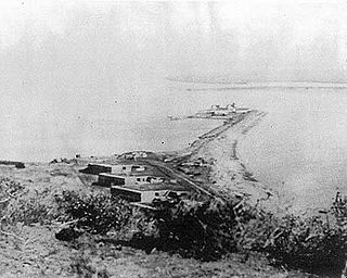
Ballast Point Whaling Station in San Diego, California, in San Diego County, is a California Historical Landmark No. 50 listed on December 6, 1935. The Ballast Point Whaling Station was built in 1858 by Captain Miles A. Johnson his cousins, Henry and James A. Johnson and the twin Packard brothers, Alpheus and William, brothers. The Portuguese-American Johnsons, Alpheus and William came to San Diego from Massachusetts in 1856. The Ballast Point Whaling Station was on Ballast Point. The whaling station processed whales to make whale oil. Whale oil was a very popular as in oil lamps it produced little smoke. Whale oil was also used in miner's headlamps, lighthouses, soaps, and candles, and as machinery lubricant. In 1869 the United States acquired the site for a quarantine station and built a lighthouse and later Fort Rosecrans, named after Major General William Rosecrans. Whaling operations at Ballast Point stopped in 1873. In 1946 the site became a U.S. Navy submarine base. The site today is Naval Base Point Loma founded in 1959. A Ballast Point Whaling Station historic marker is located on the Navy Base. Before Ballast Point Whaling Station the site was the Spanish Fort Guijarros

El Castillo de Monterey was a fortification in Monterey, California, founded in 1792 by the Spanish Empire. The fort was constructed to protect the Monterey port and the Presidio of Monterey from invaders. The site was officially listed on the National Register of Historic Places on November 23, 1971.


