
Tabelbala is a town and commune between Béchar and Tindouf in south-western Algeria, and is the capital, and only significant settlement, of the Daïra of the same name, encompassing most of the western half of Béni Abbès Province. As of the 2008 census, its population was 5,121, up from 4,663 in 1998, with an annual growth rate of 1.0%. The commune covers an area of 60,560 square kilometres (23,380 sq mi), making it by far the largest commune in the province, as well as the least densely populated.

Béni Ounif is a town and commune in Béchar Province, Algeria, coextensive with the district of Béni Ounif. It has a population of 10,732 as of the 2008 census, up from 8,199 in 1998, and had an annual growth rate of 2.8%, the second highest in the province. The commune covers an area of 16,600 square kilometres (6,400 sq mi).
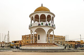
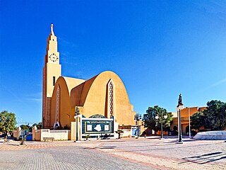
El Oued, Souf or Oued Souf is a city, and the capital of El Oued Province, in Algeria. The oasis town is watered by an underground river, hence its name is El Oued which enables date palm cultivation and the rare use of brick construction for housing. As most roofs are domed, it is known as the "City of a Thousand Domes".
Béchar is the capital city of Béchar Province, Algeria. It is also a commune, coextensive with Béchar District, of Béchar Province. In 2008 the city had a population of 165,627, up from 134,954 in 1998, with an annual growth rate of 2.1%. The commune covers an area of 5,050 square kilometres (1,950 sq mi).

Tamanrasset, also known as Tamanghasset or Tamenghest, is an oasis city and capital of Tamanrasset Province in southern Algeria, in the Ahaggar Mountains. It is the chief city of the Algerian Tuareg. It is located an altitude of 1,320 metres (4,330 ft). As of the 2008 census, it has a population of 92,635, up from 72,741 in 1998, with an annual growth rate of 2.5%.
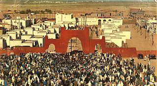
Tindouf is the main town, and a commune in Tindouf Province, Algeria, close to the Mauritanian, Western Saharan and Moroccan borders. The commune has a population of around 160,000, but the census and population estimates do not count the Sahrawi refugees, making the population as of the 2008 census 45,966, up from 25,266 in 1998, giving the town an annual population growth rate of 6.3%.

Kénadsa is a town and commune in the Sahara Desert of south-western Algeria, and is the capital of Kénadsa District, Béchar Province. As of 2008, Kénadsa had a population of 13,492, up from 11,667 in 1998, and an annual growth rate of 1.5%. The commune covers an area of 2,770 square kilometres (1,070 sq mi).

Illizi is a town and commune, coextensive with Illizi District, situated in the south-eastern part of Algeria, and capital of Illizi Province. According to the 2008 census it is the largest commune by population in the province, with a population of 17,252, up from 10,163 in 1998, and an annual population growth rate of 5.5%, the highest in the province. It is one of the gates to the Tassili N'Ajjer National Park with caves situated under the sands containing prehistoric drawings dating from 6000 years BC. There is a hotel and two camping sites, as well as many local tourist agencies.

Oum El Assel is a town and commune in the district and province of Tindouf, Algeria. At the 2008 census it had a population of 3,183, up from 1,794 in 1998, and an annual population growth rate of 6.0%. It is the least populated, largest, and least densely populated of the two communes which form the province. The town of Oum El Assel is located on the southern side of the N50 national highway 150 kilometres (93 mi) northeast of Tindouf.

Debdeb is a town and commune in In Amenas District, Illizi Province, Algeria. According to the 2008 census it has a population of 4,341, up from 3,212 in 1998, and an annual population growth rate of 3.1%, the lowest in the province. Its postal code is 33220 and its municipal code is 3303.

Béni Ikhlef is a town and commune in Kerzaz District, Béchar Province, in western Algeria. As of the 2008 census, its population was 2,459, up from 2,280 in 1998, with an annual growth rate of 0.8%. The commune covers an area of 2,617 square kilometres (1,010 sq mi).

Bayadha is a town and commune, coextensive with Bayadha District, in El Oued Province, Algeria. According to the 2008 census it has a population of 32,926, up from 26,535 in 1998, with an annual growth rate of 2.2%. Most of the commune's population lives in the urban area of the provincial capital El Oued.

Debila is a town, commune, and also the capital of Debila District. It is in El Oued Province, Algeria. According to the 2008 census, it had a population of 25,158, up from 20,088 in 1998, and an annual growth rate of 2.3%.

Djamaa is a town and commune in El M'Ghair Province, Algeria. According to the 2008 census it has a population of 50,916, up from 37,438 in 1998, with an annual growth rate of 3.1%.
Kouinine is a town and commune in El Oued District, El Oued Province, Algeria. According to the 2008 census it has a population of 10,076, up from 7,571 in 1998, with a population growth rate of 3.0%.

Magrane is a town and commune, and capital of Magrane District, in El Oued Province, Algeria. According to the 2008 census it has a population of 24,577, up from 20,102 in 1998, with an annual growth rate of 2.1%.

Robbah is a town and commune, and capital of Robbah District, in El Oued Province, Algeria. According to the 2008 census it has a population of 21,965, up from 17,243 in 1998, and an annual growth rate of 2.5%. The town lies about 10 kilometres (6.2 mi) southeast of the provincial capital El Oued and forms a part of its larger urban area.

El Ogla is a town and commune in Robbah District, El Oued Province, Algeria. According to the 2008 census it has a population of 6,102, up from 4,715 in 1998, with an annual growth rate of 2.7%.
Tarat is a village in the commune of Illizi, in Illizi Province, Algeria, located near the border with Libya beside a wadi beneath the eastern edge of the Tassili n'Ajjer mountain range.
Tarhaouhaout is a village in the commune of Tamanrasset, in Tamanrasset District, Tamanrasset Province, Algeria. It lies in the Hoggar Mountains 42 kilometres (26 mi) east of the city of Tamanrasset. Fort Motylinsky is located nearby.
