Tabelbala is a town and commune between Béchar and Tindouf in south-western Algeria, and is the capital, and only significant settlement, of the Daïra of the same name, encompassing most of the south-western half of Béchar Province. As of the 2008 census, its population was 5,121, up from 4,663 in 1998, with an annual growth rate of 1.0%. The commune covers an area of 60,560 square kilometres (23,380 sq mi), making it by far the largest commune in the province, as well as the least densely populated.

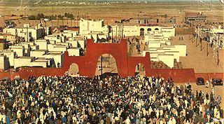
Âouinet Bel Egrâ is a village in the commune of Tindouf, in Tindouf Province, Algeria. It is in the Sahara Desert approximately 160 kilometres south-east of Tindouf. There is a Saharawi Refugee camp here named Dakhla.
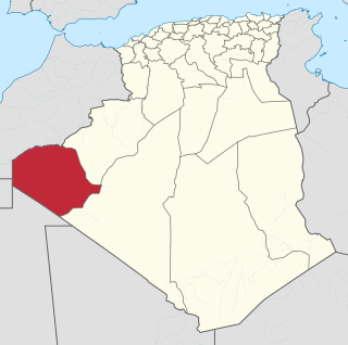
Oum El Assel is a town and commune in the district and province of Tindouf, Algeria. According to the 2008 census it has a population of 3,183, up from 1,794 in 1998, and an annual population growth rate of 6.0%. It is the least populated, largest, and least densely populated of the two communes which form the province. The town of Oum El Assel is located on the southern side of the N50 national highway 150 kilometres (93 mi) northeast of Tindouf.
Arfiane El Bared is a village in the commune of Tendla, in Djamaâ District, El Oued Province, Algeria. The village is located just to the east of the N3 highway 14 kilometres (8.7 mi) north of Djamaa, on the Biskra-Touggourt railway. The local road W303 leads through the village from the N3 on its way to Tendla.
Dendouga is a village in the commune of El M'Ghair, in El M'Ghair District, El Oued Province, Algeria. The village is 5 kilometres (3.1 mi) east of the town of El M'Ghair, to which it is connected by a local road.
Mazer Zaouia is a village in the commune of Djamaa, in Djamaâ District, El Oued Province, Algeria. The village is located just to the east of the N3 highway 4 kilometres (2.5 mi) north of Djamaa.
N'Sigha is a village in the commune of El M'Ghair, in El M'Ghair District, El Oued Province, Algeria. The village is located on the Biskra-Touggourt railway 8 kilometres (5.0 mi) north of El M'Ghair.
Méguibra is a village in the commune of Hamraia, in Reguiba District, El Oued Province, Algeria. The village is located just to the north of the N43 national highway just east of its junction with the N3 highway, and despite being in the commune of Hamraia, it is actually much nearer to the town of Still.
Sif El Menadi is a village in the commune of Reguiba, in Reguiba District, El Oued Province, Algeria. The village is located 7 kilometres (4.3 mi) southwest of the N48 highway.
Souihla is a village in the commune of Sidi Aoun, in Magrane District, El Oued Province, Algeria. The village is located to the north-west of the N3 highway 18 kilometres (11 mi) northeast of El Oued.
Oum Sahaouine is a village in the commune of El Oued, in El Oued District, El Oued Province, Algeria. The village is located 8 kilometres (5.0 mi) southeast of El Oued city, and is accessible by a local road to the south of the N16 highway.
El Kafaf is a village in the commune of Mih Ouensa, in Mih Ouensa District, El Oued Province, Algeria. The village is located on a local road that branches off to the northwest from the N16 highway, 4.5 kilometres (2.8 mi) southwest of Mih Ouensa and 27 kilometres (17 mi) southwest of the provincial capital El Oued.
El Maffa is a village in the commune of El Ouata, in Béchar Province, Algeria. The village is located on the northeast bank of the Oued Saoura 5 kilometres (3.1 mi) southeast of El Ouata. It is connected to El Ouata by a local road along the side of the river, along with the other villages Ammas, Aguedal and El Beïda.
Garet Djebilet is a settlement in the commune of Tindouf, in Tindouf Province, Algeria. The village is located 134 kilometres (83 mi) southeast of Tindouf, and is the location of an iron mine.
Hassi Mounir is a village in the commune of Oum El Assel, in Tindouf Province, Algeria. It is connected to the N50 national highway by a long local road leading southwest of the village. The village is the site of a project to introduce solar energy to Algeria, with 42 households connected to 6 solar power systems.
Hassi Khébi is a village in the commune of Oum El Assel, in Tindouf Province, Algeria. It is located on the N50 national highway between Béchar and Tindouf.
Chenachène is an isolated village in the commune of Tindouf, in Tindouf Province, Algeria.
Bou Bernous is a village in the commune of Oum El Assel, in Tindouf Province, Algeria, located in a remote part of the Sahara Desert. Bou Bernous is notable for having the highest officially recorded average high temperature in the world, at 47 °C or 116.6 °F.
Fort Lofti is a village and military base in the commune of Oum El Assel, in Tindouf Province, Algeria. It is connected to the N50 national highway by a short local road to the northwest.