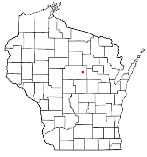
Ringle is a town in Marathon County, Wisconsin, United States. It is part of the Wausau (WI) Metropolitan Statistical Area. The population was 1,711 at the 2010 census. The unincorporated community of Ringle is located in the town.
Sturgeon River is an unorganized territory in Saint Louis County, Minnesota, United States. The population was 99 at the 2000 census.

Okondo is a town and municipality located in the province of Álava, in the Basque Country, northern Spain.

Guelmim-Es Semara was one of the sixteen former regions of Morocco from 1997 to 2015. It covered an area of 122,825 square kilometres (47,423 sq mi) and had a population of 501,921. The regional capital was Guelmim.
The Contra Costa Community College District is a community college district that encompasses three community colleges in Contra Costa County, California - Contra Costa College, Diablo Valley College and Los Medanos College. The headquarters is in the George R. Gordon Education Center in Martinez, California.

PyeongtaekJije Station is a subway station located in Pyeongtaek, South Korea. It serves the SRT and Seoul Subway Line 1. A large E-Mart store is very close to the station. On 24 November 2020, the name was changed to PyeongtaekJije.
Podole is a village in the administrative district of Gmina Zgierz, within Zgierz County, Łódź Voivodeship, in central Poland. It lies approximately 8 kilometres (5 mi) north-east of Zgierz and 13 km (8 mi) north of the regional capital Łódź.
The Coskata-Coatue Wildlife Refuge is a nature preserve on Nantucket Island and is managed by the Trustees of Reservations. It encompasses miles of beaches, the largest red cedar woodland in New England and Great Point Light. The reservation began with an acquisition of land in 1974.

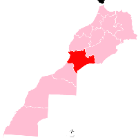
Tata is a province in the Moroccan economic region of Souss-Massa. Its population in 2004 was 121,618.

The Browns River is an approximately 20-mile (32 km) waterway in northern Vermont. It is a tributary of the Lamoille River.

The Gruta de las Maravillas is a cave in the town center of Aracena, Andalusia, Spain. It was the first Spanish cave to be opened to the public in 1913. It includes a total of 2130 subterranean meters. According to popular tradition its discoverer was a shepherd, and the first historical reference of its existence dates from 1886.
Riceville is an unincorporated community in Pittsylvania County, in the U.S. state of Virginia.
Socrum is an unincorporated community in Polk County, in the U.S. state of Florida.
Evergreen is an unincorporated community in Gallia County, in the U.S. state of Ohio.
Hamlet is a populated place in Batavia, a township of Clermont County, Ohio. Hamlet's elevation is 876 feet above sea level.
Germantown is an unincorporated community in Henry County, in the U.S. state of Missouri.

Delphi is an unincorporated community in Thurston County, in the U.S. state of Washington. The community is located approximately west of Tumwater and Black Lake. The town of Littlerock lies to the south.