
The Adams–Onís Treaty of 1819, also known as the Transcontinental Treaty, the Florida Purchase Treaty, or the Florida Treaty, was a treaty between the United States and Spain in 1819 that ceded Florida to the U.S. and defined the boundary between the U.S. and New Spain. It settled a standing border dispute between the two countries and was considered a triumph of American diplomacy. It came in the midst of increasing tensions related to Spain's territorial boundaries in North America against the United States and the United Kingdom in the aftermath of the American Revolution; it also came during the Latin American wars of independence.

Ahome is a municipality on the coast of the Gulf of California in the northwestern part of the Mexican state of Sinaloa; it is adjacent to the southern border of Sonora state. It reported 388,344 inhabitants in the 2005 census. Ahome is also the name of the second-largest community in the municipality. The municipal seat is the port city of Los Mochis, its largest community. It is the third most important municipality in the state of Sinaloa, and is a commercial corridor to the northwest of the country. It is situated on the Pacific coastal plain, at the entrance of the Gulf of California and lies in the heart of a rich agricultural region, Fort Valley. It stands at 25°33′50″N108°46′00″W.

Aragon is a census-designated place on the Tularosa River in Catron County, New Mexico, United States. As of the 2010 census it had a population of 94. It is located at an altitude of 7,135 feet (2,175 m), 7 miles (11 km) northeast of Apache Creek.

Fort Wingate was a military installation near Gallup, New Mexico. There were two other locations in New Mexico called Fort Wingate: Seboyeta, New Mexico (1849–1862) and San Rafael, New Mexico (1862–1868). The most recent Fort Wingate (1868–1993) was established at the former site of Fort Lyon, on Navajo territory, initially to control and "protect" the large Navajo tribe to its north. The Fort at San Rafael was the staging point for the Navajo deportation known as the Long Walk of the Navajo. From 1870 onward the garrison near Gallup was concerned with Apaches to the south, and through 1890 hundreds of Navajo Scouts were enlisted at the fort.

The Rio Chama, a major tributary river of the Rio Grande, is located in the U.S. states of Colorado and New Mexico. The river is about 130 miles (210 km) long altogether. From its source to El Vado Dam its length is about 50 miles (80 km), from El Vado Dam to Abiquiu Dam is about 51 miles (82 km), and from Abiquiu Dam to its confluence with the Rio Grande is about 34 miles (55 km).

KQBA is a commercial FM radio station licensed to Los Alamos, New Mexico, and serving the Santa Fe area and northern New Mexico. It is owned by Hutton Broadcasting and has a country music radio format. Its studios are in Santa Fe, and its transmitter is in Alcalde, New Mexico.
The following radio stations broadcast on AM frequency 800 kHz: 800 AM is a Mexican clear-channel frequency. XEROK Ciudad Juárez, Mexico, is the dominant station on 800 AM. See also List of broadcast station classes.

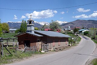
Ojo Caliente is an unincorporated community in Taos County, New Mexico, United States.
The 56-mile (90 km) High Road to Taos is a scenic, winding road through the Sangre de Cristo Mountains between Santa Fe and Taos.. It winds through high desert, mountains, forests, small farms, and tiny Spanish land grant villages and Pueblo Indian villages. Scattered along the way are the galleries and studios of traditional artisans and artists drawn by the natural beauty. It has been recognized by the state of New Mexico as an official scenic byway.

Victorio's War, or the Victorio Campaign, was an armed conflict between the Apache followers of Chief Victorio, the United States, and Mexico beginning in September 1879. Faced with arrest and forcible relocation from his homeland in New Mexico to San Carlos Indian Reservation in southeastern Arizona, Victorio led a guerrilla war across southern New Mexico, west Texas and northern Mexico. Victorio fought many battles and skirmishes with the United States Army and raided several settlements until the Mexican Army killed him and most of his warriors in October 1880 in the Battle of Tres Castillos. After Victorio's death, his lieutenant Nana led a raid in 1881.
El Rito,, is an unincorporated community in Rio Arriba County, New Mexico, United States. Its elevation is 6,875 feet (2,096 m).
Posege is one of the principal Tewa Pueblo ancestral sites in New Mexico, US. Located on the banks of the Rio Ojo Caliente at the site of Ojo Caliente, there were 13 kivas, and a population of approximately 2,000.

The Rio Ojo Caliente is a tributary of the Rio Chama mostly in Rio Arriba County, New Mexico, with a small part near Ojo Caliente in Taos County.
Los Ojos is a census-designated place (CDP) in Rio Arriba County, New Mexico, United States. Its population was 125 as of the 2010 census. Los Ojos has a post office with ZIP code 87551, which opened on February 7, 1877. The community is located near U.S. routes 64 and 84.
Los Luceros is an unincorporated community and census-designated place in Rio Arriba County, New Mexico, United States. Its population was 906 as of the 2010 census.
The District of New Mexico was a military district of the United States Army in the Territory of New Mexico that existed from 1865 to 1890. The District of Arizona and the District of New Mexico replaced the Department of New Mexico from June 27, 1865.

The Sanchez-March House, near Los Ojos, New Mexico, was built around 1880. It was listed on the National Register of Historic Places in 1985.
Fort McRae was a Union Army post, established in 1863, then a U.S. Army post from 1866 and closed in 1876, in what is now Sierra County, New Mexico. The post was named for Alexander McRae (1829–1862) a slain hero of the 1862 Battle of Valverde.
Little San Pascual Mountain is a summit in Socorro County, New Mexico. It rises to an elevation of elevation of 5,485 feet / 1,672 meters.
