
Fort George is a large 18th-century fortress near Ardersier, to the north-east of Inverness in the Highland council area of Scotland. It was built to control the Scottish Highlands in the aftermath of the Jacobite rising of 1745, replacing a Fort George in Inverness constructed after the 1715 Jacobite rising to control the area. The current fortress has never been attacked and has remained in continuous use as a garrison.

Sandgate Castle is an artillery fort originally constructed by Henry VIII in Sandgate in Kent, between 1539 and 1540. It formed part of the King's Device programme to protect England against invasion from France and the Holy Roman Empire, and defended a vulnerable point along the coast. It comprised a central stone keep, with three towers and a gatehouse. It could hold four tiers of artillery, and was fitted with a total of 142 firing points for cannon and handguns.

The Royal Commission on the Defence of the United Kingdom was a committee formed in 1859 to enquire into the ability of the United Kingdom to defend itself against an attempted invasion by a foreign power, and to advise the British Government on the remedial action required. The appointment of the Commission had been prompted by public concern about the growing military and naval power of the French Empire and was instigated by the Prime Minister, Henry Temple, 3rd Viscount Palmerston, who came to be closely associated with the project. In the following year, the Commission's report recommended a huge programme of fortification to defend the country's arsenals and naval bases. Many of the recommendations were acted upon; however, the great expense, the length of time taken to complete the various works and their perceived usefulness were all subjects of critical political, press and public debate.

Pendennis Castle is an artillery fort constructed by Henry VIII near Falmouth, Cornwall, England between 1540 and 1542. It formed part of the King's Device programme to protect against invasion from France and the Holy Roman Empire, and defended the Carrick Roads waterway at the mouth of the River Fal. The original, circular keep and gun platform was expanded at the end of the century to cope with the increasing Spanish threat, with a ring of extensive stone ramparts and bastions built around the older castle. Pendennis saw service during the English Civil War, when it was held by the Royalists, and was only taken by Parliament after a long siege in 1646. It survived the interregnum and Charles II renovated the fortress after his restoration to the throne in 1660.

Fort Manoel is a star fort on Manoel Island in Gżira, Malta. It was built in the 18th century by the Order of Saint John, during the reign of Grand Master António Manoel de Vilhena, after whom it is named. Fort Manoel is located to the north west of Valletta, and commands Marsamxett Harbour and the anchorage of Sliema Creek. The fort is an example of Baroque architecture, and was designed with both functionality and aesthetics in mind.

A bastion fort or trace italienne is a fortification in a style that evolved during the early modern period of gunpowder when the cannon came to dominate the battlefield. It was first seen in the mid-fifteenth century in Italy. Some types, especially when combined with ravelins and other outworks, resembled the related star fort of the same era.

Neuf-Brisach is a fortified town and commune of the department of Haut-Rhin in the French region of Alsace. The fortified town was intended to guard the border between France and the Holy Roman Empire and, subsequently, the German states. It was built after the Treaty of Ryswick in 1697 that resulted in France losing the town of Breisach, on the opposite bank of the Rhine. The town's name means New Breisach.

Fort Carré, often called the Fort Carré d'Antibes, is a 16th-century star-shaped fort of four arrow-head shaped bastions that stands on a 26-meter high promontory in Antibes, France. Henry II ordered construction of the fort in the 16th century at a time when Antibes was situated on a tense border with the Duchy of Savoy. During the 17th century, the Marquis de Vauban redeveloped it. The Fort was decommissioned in the early 20th century.

Hull Castle was an artillery fort in Kingston upon Hull in England. Together with two supporting blockhouses, it defended the eastern side of the River Hull, and was constructed by King Henry VIII to protect against attack from France as part of his Device programme in 1542. The castle had two large, curved bastions and a rectangular keep at its centre; the blockhouses to the north and south had three curved bastions supporting guns, and a curtain wall and moat linked the blockhouses and castle. The construction project used material from recently dissolved monasteries, and cost £21,056. The town took over responsibility for these defences in 1553, leading to a long running dispute with the Crown as to whether the civic authorities were fulfilling their responsibilities to maintain them.
Petit Bé is a tidal island near the city of Saint-Malo, France, close to the larger island of Grand Bé. At low tide one can walk to the island from the nearby Bon-Secours beach.
Ambleteuse is a commune in the Pas-de-Calais department in northern France.
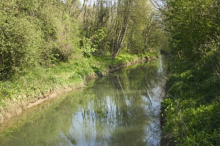
The Slack is a 22-kilometre-long (14 mi) coastal river in the Pas-de-Calais department, in northern France.

The Fortifications of Vauban is a UNESCO World Heritage Site made up of 12 groups of fortified buildings and sites along the borders of France. They were designed by renowned military architect Sébastien Le Prestre de Vauban (1633–1707) during the reign of King Louis XIV. These sites include a variety of fortifications, ranging from citadels, to mountain batteries and sea fortifications, to bastion walls and towers. In addition, the site includes cities built from scratch by Vauban and communication towers. These sites were chosen because they exemplify Vauban's work, bearing witness to the influence of his designs on military and civilian engineering on a global scale from the 17th century to the 20th century.

The fortifications of Kotor are an integrated historical fortification system that protected the medieval town of Kotor containing ramparts, towers, citadels, gates, bastions, forts, cisterns, a castle, and ancillary buildings and structures. They incorporate military architecture of Illyria, the Byzantine Empire, Venice, and Austria. Together with the old town and its natural surroundings the fortifications were inscribed in the list of World Heritage Sites in 1979 labelled Natural and Culturo-Historical Region of Kotor and represent the only such site of cultural significance in Montenegro.

Fort Chambray or Fort Chambrai is a bastioned fort located in the precincts of Għajnsielem, on the island of Gozo, Malta. It was built in the mid-18th century by the Order of Saint John, in an area known as Ras it-Tafal, between the port of Mġarr and Xatt l-Aħmar. The fort was meant to be the citadel of a new city which was to replace the Cittadella as the island's capital, but this plan never materialized.

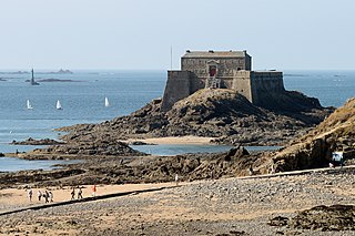
Fort National is a fort on a tidal island a few hundred metres off the walled city of Saint-Malo. The great military architect Vauban had it built in 1689 to protect Saint-Malo's port.
Fort de la Conchée is a fortification on the rocky island of Quincé, four kilometers north-west of St Malo, France. Constructed by Sébastien Vauban the fort covers almost the entire island. The fortress consists of a service building built on high, thick granite masonry walls two stories high. An oval upper terrace with embrasures facing the open sea served as the fort's site for the fort's battery. Today, the fort is a nature reserve for seabirds.
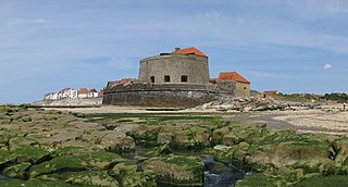
Fort Louvois, which is known locally as Fort Chapus or Fort du Chapus, is a fortification built between 1691 and 1694, during the reign of Louis XIV, on the Chapus islet, and is about 400 metres (1,300 ft) offshore in the town of Bourcefranc-le-Chapus in the department of Charente-Maritime, France. The fort sits opposite the citadel of Château d'Oléron on the island of Oléron. The fort was positioned so that a crossfire from the château and the fort would control the Pertuis de Maumusson and impede access to the Rochefort roads from the south. Fort Louvois only saw action towards the end of World War II when bombardment greatly damaged the fort, necessitating later restoration.

Cove Fort is a small bastioned land battery to the east of Cobh in County Cork, Ireland. Built as a coastal defence fortification in 1743, on instruction of the then Vice-Admiral of the Coast, it replaced a number of temporary coastal artillery batteries which defended Cork Harbour.
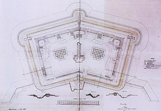
A polygonal fort is a type of fortification originating in France in the late 18th century and fully developed in Germany in the first half of the 19th century. Unlike earlier forts, polygonal forts had no bastions, which had proved to be vulnerable. As part of ring fortresses, polygonal forts were generally arranged in a ring around the place they were intended to protect, so that each fort could support its neighbours. The concept of the polygonal fort proved to be adaptable to improvements in the artillery which might be used against them, and they continued to be built and rebuilt well into the 20th century.
