Related Research Articles

Columbia County is a county located in the north central portion of the U.S. state of Florida. As of the 2020 census, the population was 69,698, up from 67,531 at the 2010 census. Its county seat is Lake City.

Ware County is a county located in the southeastern part of the U.S. state of Georgia. As of the 2020 census, the population was 36,251. The county seat and only incorporated place is Waycross.

Telfair County is a county located in the central portion of the U.S. state of Georgia. As of the 2020 census, the population was 12,477. The largest city and county seat is McRae-Helena.

Tattnall County is a county located in the southeast portion of the U.S. state of Georgia, located within the Magnolia Midlands, a part of the Historic South region. As of the 2020 census, the population was 22,842. The county seat is Reidsville. Tattnall County was created on December 5, 1801, from part of Montgomery County, Georgia by the Georgia General Assembly.

Glynn County is located in the southeastern part of the U.S. state of Georgia. As of the 2020 census, the population was 84,499. The county seat is Brunswick. Glynn County is part of the Brunswick, Georgia Metropolitan Statistical Area.

Crawford County is a county located in the central portion of the U.S. state of Georgia. As of the 2020 census, the population was 12,130. The county seat is Knoxville.

Camden County is a county located in the southeastern corner of the U.S. state of Georgia. According to the 2020 Census, its population was 54,768. Its county seat is Woodbine, and the largest city is St. Marys. It is one of the original counties of Georgia, created February 5, 1777. It is the 11th-largest county in the state of Georgia by area, and the 41st-largest by population.

Bryan County is a county located in the U.S. state of Georgia. As of the 2020 census, the population was 44,738. The county seat is Pembroke.

Brantley County is a county located in the southeastern part of the U.S. state of Georgia. As of the 2020 census, the population was 18,021. The county seat is Nahunta. Brantley County is part of the Brunswick, Georgia Metropolitan Statistical Area.

Middleburg is an unincorporated area and census-designated place (CDP) within Clay County in the U.S. state of Florida, located 26 miles (42 km) southwest of downtown Jacksonville and 16 miles (26 km) northwest of Green Cove Springs, the county seat of Clay County. As of the 2020 census, the population of Middleburg was 12,881.
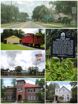
Fort White is a town in Columbia County, Florida, United States, named after a military fort built in the 1830s. It is the closest town to Ichetucknee Springs State Park. Fort White High School and the Fort White Public School Historic District are located within the town's borders. The original school building was constructed in 1915.
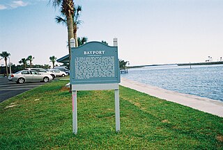
Bayport is an unincorporated community and census-designated place (CDP) in Hernando County, Florida, United States. The population was 43 at the 2010 census.

Macon, officially Macon–Bibb County, is a consolidated city-county in Georgia, United States. Situated near the fall line of the Ocmulgee River, it is 85 miles (137 km) southeast of Atlanta and near the state's geographic center — hence its nickname "The Heart of Georgia."

Douglas is a city in Coffee County, Georgia, United States. As of the 2020 census, the city had a population of 11,722. Douglas is the county seat of Coffee County and the core city of the Douglas, Georgia Micropolitan Statistical Area, which had a population of 50,731 as of the 2010 census.

Perry is a city in Houston and Peach counties in the U.S. state of Georgia. It is the county seat of Houston County. The population was 13,839 at the 2010 census, up from 9,602 at the 2000 census. As of 2019 the estimated population was 17,894. It is part of the Warner Robins, Georgia Metropolitan Statistical Area, within the Macon–Bibb County–Warner Robins Combined Statistical Area.

Egmont Key National Wildlife Refuge and State Park is a National Wildlife Refuge and State Park located on the island of Egmont Key, at the mouth of Tampa Bay. Egmont Key lies southwest of Fort De Soto Park and can only be reached by boat or ferry. Located within Egmont Key National Wildlife Refuge and State Park are the 1858 Egmont Key Lighthouse, maintained by the U.S. Coast Guard, and the ruins of Fort Dade, a Spanish–American War era fort that housed 300 residents. Egmont Key is located in Hillsborough County Florida on a narrow strip of the county that extends along the Tampa Port Shipping Channel.
Moniac is an unincorporated community situated along the St. Marys River, in southern Charlton County in the U.S. state of Georgia. Part of the "Georgia Bend", the area was an early trading post in the 1820s as the last outpost before crossing into the Florida territory. To protect the settlement from Indian raids, a fort named Fort Moniac was built across the St. Marys from the settlement in 1838. The settlement's name comes from Colonel David Moniac, a creek Indian and West Point graduate who was killed during the second Seminole Indian War. The fort was dismantled in 1842.
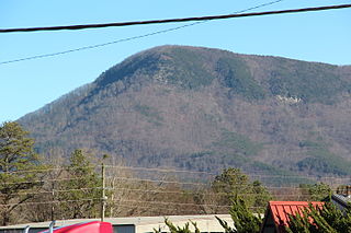
Fort Mountain is a mountain in northern Georgia, just east of Chatsworth. It is part of the Cohutta Mountains, a small mountain range at the southern end of the Appalachian Mountains. It also lies within the Chattahoochee National Forest.
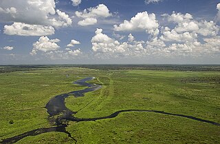
Fisheating Creek is a stream that flows into Lake Okeechobee in Florida. It is the only remaining free-flowing water course feeding into the lake, and the second-largest natural source for the lake. Most of the land surrounding the stream is either publicly owned or under conservation easements restricting development. The lower part of the stream remains in a largely natural state, and efforts are underway to restore the upper part of the stream to a more natural state.
Racepond is an unincorporated community in Charlton County, in the U.S. state of Georgia.
References
- ↑ Candler, Allan (1906). Georgia Comprising Sketches of Counties, Towns, etc, Vol II. State Historical Association. p. 65.
- ↑ "Georgia Forts" . Retrieved January 9, 2019.
- ↑ Georgia Department of Natural Resources. Wildlife Resources Division. "Locations of Special Concern Animals, Plants and Natural Communities by Quarter Quad Names Starting with (F)". Archived from the original on July 20, 2011. Retrieved April 7, 2011.
31°03′51.81″N82°11′11.44″W / 31.0643917°N 82.1865111°W
Municipalities and communities of Brantley County, Georgia, United States | ||
|---|---|---|
| Cities |  | |
| CDPs | ||
| Unincorporated community | ||
| | This Brantley County, Georgia state location article is a stub. You can help Wikipedia by expanding it. |