
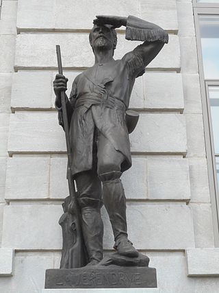
Pierre Gaultier de Varennes, sieur de La Vérendrye was a French Canadian military officer, fur trader, and explorer. In the 1730s, he and his four sons explored the area west of Lake Superior and established trading posts there. They were part of a process that added Western Canada to the original New France territory that was centred along the Saint Lawrence basin.

The Saskatchewan River is a major river in Canada. It stretches about 550 kilometres (340 mi) from where it is formed by the joining of the North Saskatchewan River and South Saskatchewan River just east of Prince Albert, Saskatchewan, to Lake Winnipeg. It flows roughly eastward across Saskatchewan and Manitoba to empty into Lake Winnipeg. Through its tributaries the North Saskatchewan and South Saskatchewan, its watershed encompasses much of the prairie regions of Canada, stretching westward to the Rocky Mountains in Alberta and north-western Montana in the United States.
Anthony Henday was one of the first Europeans to explore the interior of what would eventually become western Canada. He ventured farther westward than any white man had before him. As an employee of the Hudson's Bay Company, he travelled across the prairies in the 1750s, journeyed into what is now central Alberta, and possibly arrived at the present site of Red Deer. He camped along the North Saskatchewan River, perhaps on the present site of Rocky Mountain House or Edmonton, and is said to have been the first European to see the Rocky Mountains, if only from a distance.

Cumberland House is a community in Census Division No. 18 in northeast Saskatchewan, Canada on the Saskatchewan River. It is the oldest community in Saskatchewan and has a population of about 2,000 people. Cumberland House Provincial Park, which provides tours of an 1890s powder house built by the Hudson's Bay Company, is located nearby.

Louis-Joseph Gaultier de La Vérendrye was a French Canadian fur trader and explorer. He, his three brothers, and his father Pierre La Vérendrye pushed trade and exploration west from the Great Lakes. He, his brother, and two colleagues are thought to be the first Europeans to have crossed the northern Great Plains and seen the Rocky Mountains in Wyoming.
Pierre Gaultier de La Vérendrye de Boumois was the second son of Pierre Gaultier de Varennes, sieur de La Vérendrye. An explorer and fur trader who served many years under the command of his father, he was born on Île aux Vaches, near Sorel, New France.
Christopher Dufrost de La Jemeraye ,(b. December 6, 1708 – d. May 10, 1736), was the lieutenant and nephew of Pierre Gaultier de Varennes et de La Vérendrye in the exploratory party that headed west from Fort Kaministiquia, Ontario, Canada, in 1731. He and Jean Baptiste de La Vérendrye established Fort St. Charles on Lake of the Woods in 1732. In the spring of 1733, he and Jean Baptiste headed down the Winnipeg River to set up a post in the Lake Winnipeg area. Ice stopped them and La Jemeraye returned to Fort St. Charles while his cousin established a small temporary fort named La Barrière.

Louis de la Corne, Chevalier de la Corne was a Canadian-born military officer and merchant. He was born at Fort Frontenac in what is now Kingston, Ontario, Canada, and began his career in the colonial regular troops as a second ensign in 1722 and was made full ensign five years later. He married in 1728 and began investing heavily in the commerce of the fur trade while continuing his military career. This was a common practice of the time. In the next few years both careers flourished. He received promotions to lieutenant and then captain six years later.
Jacques Legardeur de Saint-Pierre was a Canadian colonial military commander and explorer who held posts throughout North America in the 18th century, just before and during the French and Indian War.
Fort Bourbon was one of the forts built by La Vérendrye during his expansion of trade and exploration west from Lake Superior. Besides providing support for the important fur trade in what is now Manitoba, La Vérendrye wanted to conduct exploration of potential routes for what he believed was an interior western sea.
Fort La Reine was built in 1738 and is one of the forts of the western expansion directed by Pierre Gaultier de Varennes et de La Vérendrye, first military commander in the west of what is now known as Canada. Located on the Assiniboine River where present day Portage la Prairie, Manitoba, stands, the fort served as a fur trading post. It was also the base of operations for much exploration north and west. From Fort La Reine, explorers made their way to Lake Manitoba and Lake Winnipegosis, Lake Winnipeg and the Saskatchewan River.
Fort La Jonquière was a French fort built along the Saskatchewan River in the spring of 1751. It was purported to have been the furthest west outpost of New France. The fort was named after the Governor General of New France at the time, Jacques-Pierre de Taffanel de la Jonquière, Marquis de la Jonquière, by Jacques Legardeur de Saint-Pierre, western commander of the French (1750-1753). There is no surviving record of its exact location, nor physical evidence, but it was most likely located near Nipawin, Saskatchewan.

Fort de la Corne was one of the two French forts established on the Saskatchewan River in the 20 years between the end of La Vérendrye's push west from Lake Superior in 1731–1743 and the fall of New France in 1763.
Luc de la Corne was a Canadian-born military officer, merchant, interpreter and politician.

Carrot River is a river in Western Canada in the north-eastern part Saskatchewan and the north-western part of Manitoba. The outlet of Wakaw Lake in Saskatchewan marks the beginning of the Carrot River and, from there, it flows north-east past several communities and Indian reserves until it joins the Saskatchewan River in the Cumberland Delta in Manitoba. The river's mouth is west and upstream of the Pasquia River and The Pas on the Saskatchewan River.
Joseph La France,, was a Métis fur trader in Canada, and an explorer of the inland route from Montreal to Hudson Bay.
Bas de la Rivière is a geographical area on both sides of the Winnipeg River at and near the mouth where it empties into Lake Winnipeg. It had a storied historical period in the opening of the west and the subsequent fur trade and settlement.

Saskatchewan River fur trade The Saskatchewan River was one of the two main axes of Canadian expansion west of Lake Winnipeg. The other and more important one was northwest to the Athabasca Country. For background see Canadian canoe routes (early). The main trade route followed the North Saskatchewan River and Saskatchewan River, which were just south of the forested beaver country. The South Saskatchewan River was a prairie river with few furs.
Asleep by the frozen sea is a phrase coined by Joseph Robson to describe the policy of the Hudson's Bay Company (HBC) from its foundation in 1670 until the establishment of its first inland post in 1774. Unlike the French who sent Coureurs des bois inland to trade, the HBC built posts on Hudson Bay and waited for the Indians to bring furs to them. The decision to abandon this policy and move inland gradually turned the HBC into an informal government for western Canada and led ultimately to the confederation of western and eastern Canada.

On June 6, 1736, a party of twenty one French explorers led by Jean Baptiste de La Vérendrye were massacred by Lakota and Dakota warriors on an island in Lake of the Woods. The massacre came about as a result of a recent French alliance with the Cree, who, under French protection, had been attacking Lakotas. The explorers had been en route to Fort Kaminstiquia on the northern shore of Lake Superior when the group of about one hundred warriors descended on and killed them in revenge for the French-sponsored Cree raids and French slave trading.

