
St. Simons Island is a barrier island and census-designated place (CDP) located on St. Simons Island in Glynn County, Georgia, United States. The names of the community and the island are interchangeable, known simply as "St. Simons Island" or "SSI", or locally as "The Island". St. Simons is part of the Brunswick metropolitan statistical area, and according to the 2020 U.S. census, the CDP had a population of 14,982. Located on the southeast Georgia coast, midway between Savannah and Jacksonville, St. Simons Island is both a seaside resort and residential community. It is the largest of Georgia's renowned Golden Isles. Visitors are drawn to the Island for its warm climate, beaches, variety of outdoor activities, shops and restaurants, historical sites, and natural environment.

Darien is a city in and the county seat of McIntosh County, Georgia, United States. It lies on Georgia's coast at the mouth of the Altamaha River, approximately 50 miles south of Savannah, and is part of the Brunswick, Georgia metropolitan statistical area. It is the second-oldest planned city in Georgia and was originally called New Inverness. The population of Darien was 1,460 at the 2020 census, down from 1,975 in 2010.

Fort Frederica National Monument, on St. Simons Island, Georgia, preserves the archaeological remnants of a fort and town built by James Oglethorpe between 1736 and 1748 to protect the southern boundary of the British colony of Georgia from Spanish raids. About 630 British troops were stationed at the fort.

Amelia Island is a part of the Sea Islands chain that stretches along the East Coast of the United States from South Carolina to Florida; it is the southernmost of the Sea Islands, and the northernmost of the barrier islands on Florida's Atlantic coast. Lying in Nassau County, Florida, it is 13 miles (21 km) long and approximately 4 miles (6.4 km) wide at its widest point. The communities of Fernandina Beach, Amelia City, and American Beach are located on the island.
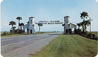
Jekyll Island is located off the coast of the U.S. state of Georgia, in Glynn County. It is one of the Sea Islands and one of the Golden Isles of Georgia barrier islands. The island is owned by the State of Georgia and run by a self-sustaining, self-governing body.

Cumberland Island, in the southeastern United States, is the largest of the Sea Islands of Georgia. The long-staple Sea Island cotton was first grown here by a local family, the Millers, who helped Eli Whitney develop the cotton gin. With its unusual range of wildlife, the island has been declared a National Seashore. Little Cumberland Island is connected to the main island by a marsh.

The Battle of Bloody Marsh took place on 7 July 1742 between Spanish and British forces on St. Simons Island, part of the Province of Georgia, resulting in a victory for the British. Part of the War of Jenkins' Ear, the battle was for the British fortifications of Fort Frederica and Fort St. Simons, with the strategic goal the sea routes and inland waters they controlled. With the victory, the Province of Georgia established undisputed claim to the island. The British also won the Battle of Gully Hole Creek, which took place on the island the same day.
The Golden Isles of Georgia consist of barrier islands, and the mainland port cities of Brunswick and Darien on the 100-mile-long coast of the U.S. state of Georgia on the Atlantic Ocean. They include St. Simons Island, Sea Island, Jekyll Island, Little St. Simons Island, Sapelo Island, and Blackbeard Island. The islands are part of a long chain of barrier islands known as the "Sea Islands", located along the coasts of South Carolina, Georgia and northern Florida.
The Battle of Gully Hole Creek took place on July 18, 1742, between Spanish and British forces in the Province of Georgia, resulting in a victory for the British. Part of a much larger conflict, known as the War of Jenkins' Ear, the battle was for control of St. Simons Island, the British fortifications of Fort Frederica and Fort St. Simons, and the strategic sea routes and inland waters they controlled. After the victory, the Province of Georgia established undisputed claim to the island, which is now part of the U.S. state of Georgia. The better-known Battle of Bloody Marsh, a skirmish also won by the British, took place on the island the same day.

Fort Mose is a former Spanish fort in St. Augustine, Florida. In 1738, the governor of Spanish Florida, Manuel de Montiano, had the fort established as a free black settlement, the first to be legally sanctioned in what would become the territory of the United States. It was designated a US National Historic Landmark on October 12, 1994.

Fort King George State Historic Site is a fort located in the U.S. state of Georgia in McIntosh County, adjacent to Darien. The fort was built in 1721 along what is now known as the Darien River and served as the southernmost outpost of the British Empire in the Americas until 1727. The fort was constructed in what was then considered part of the colony of South Carolina, but was territory later settled as Georgia. It was part of a defensive line intended to encourage settlement along the colony's southern frontier, from the Savannah River to the Altamaha River. Great Britain, France, and Spain were competing to control the American Southeast, especially the Savannah-Altamaha River region.
The siege of St. Augustine was a military engagement that took place during June–July 1740. It involved a British attack on the city of St. Augustine in Spanish Florida and was a part of the much larger conflict known as the War of Jenkins' Ear.

Tabby is a type of concrete made by burning oyster shells to create lime, then mixing it with water, sand, ash and broken oyster shells. Tabby was used by early Spanish settlers in present-day Florida, then by British colonists primarily in coastal South Carolina and Georgia. It is a man-made analogue of coquina, a naturally-occurring sedimentary rock derived from shells and also used for building.

The Wormsloe Historic Site, originally known as Wormsloe Plantation, is a state historic site near Savannah, Georgia, in the southeastern United States. The site consists of 822 acres (3.33 km2) protecting part of what was once the Wormsloe Plantation, a large estate established by one of Georgia's colonial founders, Noble Jones. The site includes a picturesque 1.5 miles (2.4 km) oak avenue, the ruins of Jones' fortified house built of tabby, a museum, and a demonstration area interpreting colonial daily life.
Manuel Joaquín de Montiano y Sopelana was a Spanish General and colonial administrator who served as Royal Governor of La Florida during Florida's First Spanish Period and as Royal Governor of Panama. He defended Florida from an attack by British forces in 1740 and launched his own unsuccessful Invasion of Georgia during the War of Jenkins' Ear.
In the 1742 Invasion of Georgia, Spanish forces based in Florida attempted to seize and occupy disputed territory held by the British colony of Georgia. The campaign was part of a larger conflict which became known as the War of Jenkins' Ear. Local British forces under the command of the Governor James Oglethorpe rallied and defeated the Spaniards at the Battle of Bloody Marsh and the Battle of Gully Hole Creek, forcing them to withdraw. Britain's ownership of Georgia was formally recognized by Spain in the subsequent Treaty of Madrid.
Trustee Georgia is the name of the period covering the first twenty years of Georgia history, from 1732–1752, because during that time the English Province of Georgia was governed by a board of trustees. England's King George II, for whom the colony was named, signed a charter establishing the colony and creating its governing board on July 7, 1732. His action culminated a lengthy process. Tomochichi was a Native American that resides along the Savannah River that allowed Oglethorpe to settle on the Yamacraw Bluff.
The Battle of Fort Mose was a significant action of the War of Jenkins' Ear that took place on June 14, 1740 in Spanish Florida. Captain Antonio Salgado commanded a Spanish column of 300 regular troops, backed by the free black militia under Francisco Menéndez and allied Seminole warriors consisting of Indian auxiliaries. They stormed Fort Mose, a strategically crucial position newly held by 170 British soldiers under Colonel John Palmer. Palmer and his garrison had taken the fort from the Spanish as part of James Oglethorpe's offensive to capture St. Augustine.

Lieutenant-General James Edward Oglethorpe was a British Army officer, Tory politician and colonial administrator best known for founding the Province of Georgia in British North America. As a social reformer, he hoped to resettle Britain's "worthy poor" in the New World, initially focusing on those in debtors' prisons.

Fort San Francisco de Pupo was an 18th-century Spanish fort on the west bank of the St. Johns River in Florida, about eighteen miles from St. Augustine, the capital of Spanish Florida. Lying on the old trail to the Spanish province of Apalachee in western Florida, Fort Pupo and its sister outpost, Fort Picolata on the opposite shore of the river, controlled all traffic on the ferry crossing. The remains of Fort Pupo are situated about three miles south of Green Cove Springs in Clay County, near the end of Bayard Point opposite Picolata. The surrounding area is a hammock of southern live oak, southern magnolia, pignut hickory and other typical trees native to the region.

