Related Research Articles

The Peace River is a 1,923-kilometre-long (1,195 mi) river in Canada that originates in the Rocky Mountains of northern British Columbia and flows to the northeast through northern Alberta. The Peace River joins the Athabasca River in the Peace-Athabasca Delta to form the Slave River, a tributary of the Mackenzie River. The Finlay River, the main headwater of the Peace River, is regarded as the ultimate source of the Mackenzie River. The combined Finlay–Peace–Slave–Mackenzie river system is the 13th longest river system in the world.

Vermilion-Lloydminster was a provincial electoral district in Alberta, Canada, mandated to return a single member to the Legislative Assembly of Alberta using first past the post method of voting from 1993 to 2019.
Vermilion is a town in central Alberta, Canada that is surrounded by the County of Vermilion River. It is at the intersection of Highway 16 and Highway 41, approximately 60 kilometres (37 mi) west of Lloydminster and 192 kilometres (119 mi) east of Edmonton.

High Level is a town in northern Alberta, Canada. It is located at the intersection of the Mackenzie Highway and Highway 58, approximately 733 kilometres (455 mi) north of Edmonton and 725 km (450 mi) south of Yellowknife, Northwest Territories. High Level is located within Mackenzie County and was founded in 1947. The town serves a trading area of approximately 20,000 people.

Battle River-Wainwright was a provincial electoral district in Alberta, Canada mandated to return a single member to the Legislative Assembly of Alberta using the first-past-the-post method of voting from 2004 to 2019.

Fort Vermilion is a hamlet on the Peace River in northern Alberta, Canada, within Mackenzie County.

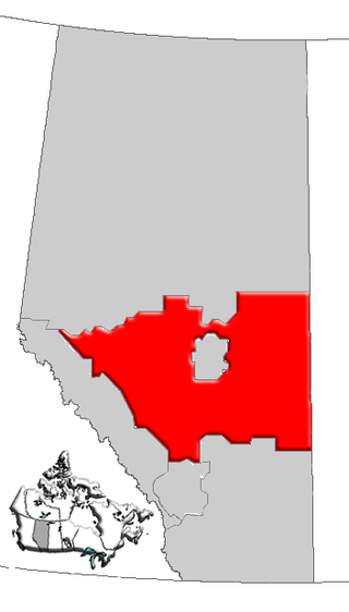
Division No. 17 is a census division in Alberta, Canada. It spans the central and northwest portions of northern Alberta and its largest urban community is the Town of Slave Lake. Division No. 17 is the largest census division in Alberta according to area and also has the lowest population density.

The County of Vermilion River is a municipal district located in the eastern part of central Alberta, Canada in Census Division No. 10. The municipal district was formerly named the County of Vermilion River No. 24 prior to an official name change that became effective on September 13, 2006.

Rainbow Lake is a town in northwest Alberta, Canada. It is west of High Level at the end of Highway 58, in Mackenzie County.

David Graeme Hancock is a Canadian lawyer and was the 15th premier of Alberta in 2014. Since 2017, he has served as a judge of the Provincial Court of Alberta. From 1997 to 2014, he was a Member of the Legislative Assembly of Alberta representing Edmonton-Whitemud as a Progressive Conservative until announcing his resignation from the legislature on September 12, 2014.
Central Alberta is a region located in the Canadian province of Alberta.
CIAM-FM is a community Christian radio station broadcasting at 92.7 MHz on the FM dial in Fort Vermilion, Alberta, Canada. CIAM-FM is a listener supported community broadcast. CIAM Media & Radio Broadcasting Association is the registered charity that holds the broadcast license.
Vegreville-Viking was a provincial electoral district in Alberta, Canada, mandated to return a single member to the Legislative Assembly of Alberta from 1993 to 2004.

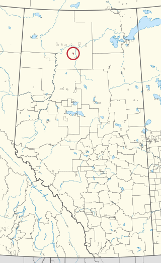
Red Earth Creek is a hamlet in Alberta, Canada within the Municipal District of Opportunity No. 17. It is located east of Highway 88, between the town of Slave Lake and the hamlet of Fort Vermilion, and has an elevation of 520 metres (1,710 ft).
Islay is a hamlet in central Alberta, Canada within the County of Vermilion River. Previously an incorporated municipality, Islay dissolved from village status on March 15, 1944, to become part of the Municipal District of Vermilion Valley No. 482. The community was named after Islay, in Scotland, the ancestral home of pioneer settlers.

Fort Vermilion 173B is an Indian reserve of the Tallcree First Nation in Alberta, located within Mackenzie County. It is 1 kilometre southwest of Fort Vermilion. In the 2016 Canadian Census, it recorded a population of 96 living in 23 of its 25 total private dwellings.

Vermilion-Lloydminster-Wainwright is a provincial electoral district in Alberta, Canada. The district is one of 87 districts mandated to return a single member (MLA) to the Legislative Assembly of Alberta using the first-past-the-post method of voting. It was contested for the first time in the 2019 Alberta election.
Tallcree 173A, also known as North Tallcree, is an Indian reserve of the Tallcree First Nation in Alberta, located within Mackenzie County. It is 40 kilometres (25 mi) southeast of Fort Vermilion. In the 2021 Canadian Census, Tallcree 173A had a recorded population of 201 living in 50 of its 56 total private dwellings.