
The Fortress of Luxembourg is the former fortifications of Luxembourg City, the capital of the Grand Duchy of Luxembourg, which were mostly dismantled beginning in 1867. The fortress was of great strategic importance for the control of the Left Bank of the Rhine, the Low Countries, and the border area between France and Germany.

Ouvrage Cap Martin is a work of the Maginot Line's Alpine extension, the Alpine Line, also called the Little Maginot Line. The ouvrage, located on high ground in Roquebrune, consists of two artillery blocks and one combination block facing Italy. The ouvrage was at the southernmost end of the Alpine Line and overlooked the Mediterranean Sea coastline at an altitude of 21 meters between Nice and Menton, facing towards Italy. The ouvrage and its advance casemate at Pont Saint Louis controlled the coastal roads along the Mediterranean.

The Fortified Sector of the Dauphiné was the French military organization that in 1940 controlled the section of the Alpine Line portion of the Maginot Line facing Italy in the vicinity of Briançon. By comparison with the integrated defenses of the main Maginot Line, or even of the Fortified Sector of the Maritime Alps to the south, the Dauphiné sector consisted of a series of distinct territories that covered two main invasion routes into France: the route from Turin over the Col de Montgenèvre to Briançon and Grenoble, and the route from Coni over the Col de Larche to Barcelonette and Gap. The sector was the scene of probing attacks by Italian forces during the Italian invasion of France in 1940, in which the French defenses successfully resisted Italian advances until the June 1940 armistice that granted Italy access to southeastern France.

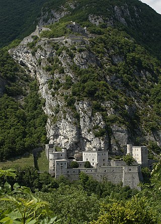
Fortress Saint-Maurice is one of the three main fortification complexes comprising the Swiss National Redoubt. The westernmost of the three, Fortress Saint-Maurice complements Fortress Saint Gotthard and Fortress Sargans to secure the central alpine region of Switzerland against an invading force. The National Redoubt was first conceived in the 1880s as an easily defensible area to secure the survival of the Swiss Confederation. In the late 1930s and 1940s when neutral Switzerland was threatened with invasion from Germany, the National Redoubt and its components were modernized and expanded on a massive scale. The fortification system was maintained and upgraded during the Cold War. With the collapse of the Soviet Union, the possibility of a Warsaw Pact invasion disappeared, and by 1995 many positions were abandoned by the military.

The Grotte aux Fées in the cliffs above Saint-Maurice, Switzerland is a natural limestone solution show cave, featuring a 77-metre (253 ft) high underground waterfall, claimed as the world's highest waterfall in a show cave. The cave was the first show cave in Switzerland. The cave was known until the mid 19th century as the Trou aux Fayes or "Sheep Hole," as it was used as a sheepfold. The cave was known from Roman times, but was first publicized in 1863 as a tourist attraction, with the present name being used from 1865.
The Fort de Cindey is a component of Fortress Saint-Maurice, which is in turn one of the three principal fortified regions of the National Redoubt of Switzerland. The Fort de Cindey was built in two steps: the first, between 1941 and 1946 and the second step, between 1948 and 1954. It was taken out of service in 1995. This fort was built in the Scex cliff face immediately to the west of Saint-Maurice to complement the existing Fort du Scex, built earlier in the same cliff. With the Fort du Scex, it comprises a fortress complex encased in rock high above the strategic Saint-Maurice valley. The fort was deactivated in 1995. It is now open for public tours during the summer months.

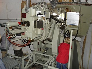
The Fort de Dailly is the largest component of Fortress Saint-Maurice, which is in turn one of the three principal fortified regions of the National Redoubt of Switzerland. Almost entirely subterranean, the Fort de Dailly was built in the Massif de Dailly to the east of Saint-Maurice beginning in 1892. With the Fort de Savatan, it comprises a fortress complex encased in rock high above the strategic Saint-Maurice valley, capable of commanding the valley from Chillon to Martigny. It is the central component of Fortress Saint-Maurice in terms of both its position and its military power. Construction began in 1892 and the fort became operational in 1894. The fort was nearly constantly upgraded with new artillery in increasingly secure positions. Following an incident in which three ammunition magazines exploded in close succession in 1946, the fort was repaired and upgraded with two fully automatic 150mm gun turrets with a range of 24 kilometres (15 mi). After reassessments by the Swiss Armed Forces of their requirements for fixed fortifications, Dailly was progressively closed down starting in 1995, with full closure at the end of 2003.

The Fort de Chillon is a twentieth-century fortification directly adjacent to the medieval Château de Chillon on the edge of Lake Geneva in Switzerland. The fort secures the road and rail lines that pass along the lakeshore running east from Lausanne to the mountainous interior of Switzerland. The position is an advanced work protecting the approaches to Fortress Saint-Maurice, part of the Swiss National Redoubt. Deactivated as a military post in 1995, it is privately owned and is being converted to a wine cellar.
The Fort de Champillon is a twentieth-century Swiss fortification located in the heights overlooking the Rhône valley from the north between Montreux and Monthey. Completed in 1944, the fort secures the road and rail lines running east from Lausanne to the mountainous interior of Switzerland. The position is an advanced work protecting the approaches to Fortress Saint-Maurice, part of the Swiss National Redoubt. It is entered from the plateau just downhill from Corbeyrier, a village on the heights at the foot of the Tour d'Aï.

The Fort de Pré-Giroud, also known as the Fort de Vallorbe, is a 20th-century Swiss fortification located in the Jura Mountains near the Swiss border with France. The fort defended the Col de Jougne at Vallorbe, one of the few points in the Jura that could be easily traversable by an invading force. It was a component of the Swiss Border Line of defenses. Built between 1937 and 1939, the fort covers the Swiss end on the Mont d'Or railroad tunnel and the Joux valley. It is armed with three artillery blocks for 75mm guns and two machine gun blocks. All are camouflaged, the artillery blocks as rock formations, and the machine gun blocks as houses. Deactivated as a military post in the 1980s, it is operated as a museum.

The Border Line defenses of Switzerland were constructed in the late 1930s in response to increasing tensions between Switzerland and its neighbours, chiefly the Axis powers of Germany and Italy. The Border Line was planned to slow or hold an invading force at the border. It consisted of a series of bunkers spaced at short intervals along the French, German and Austrian borders. The bunkers were reinforced by larger multi-blockhouse forts at key points. Most of the positions were within two or three kilometers of the frontier.

The Fortified Sector of Colmar was the French military organization that in 1940 controlled the section of the French frontier with Germany in the vicinity of Colmar. The fortifications were built as part of France's Maginot Line defensive strategy, but the sector lacks the large interconnected fortifications found along France's land border with Germany. The sector's principal defense was the Rhine itself, which could be crossed only by boat or by seizing a bridge crossing. The sector's fortifications chiefly took the form of casemates and blockhouses. The SF Colmar was flanked to the north by the Fortified Sector of the Lower Rhine to the north and the Fortified Sector of Mulhouse to the south. The Colmar sector was directly attacked by German forces on 15 June 1940, capturing or destroying most of the fortifications in the sector in three days.

The Fortified Sector of the Lower Rhine was the French military organization that in 1940 controlled the section of the French frontier with Germany in the vicinity of Strasbourg. The sector's principal defence was the Rhine itself, which could be crossed only by boat or by seizing a bridge crossing. While it was constructed by CORF, the organization responsible for the construction of the Maginot Line, the SF Lower Rhine was not a part of the core Line fortifications. The sector's fortifications chiefly took the form of individual casemates and blockhouses. Additional support was provided by the fortress ring around Strasbourg, whose fortifications were still active in 1940. The SF Lower Rhine was flanked to the north by the Fortified Sector of Haguenau and to the south by the Fortified Sector of Colmar. The Rhinau section of the SF Lower Rhine was attacked by German forces in June 1940 as a diversion from the main German invasion operation in the SF Colmar. Follow-up incursions from the north and at Strasbourg left much of the SF Lower Rhine in German hands by the armistice of 25 June.

The Fortified Sector of Rohrbach was the French military organization that in 1940 controlled the section of the Maginot Line in the vicinity of Bitche. The sector was bordered to the west by the Fortified Sector of the Sarre and to the east by the Fortified Sector of the Vosges. With lower priority than other sectors, the SF Rohrbach was built somewhat later than its neighbors to the east and west, and in company with positions on the extreme western end of the Maginot Line, became one of the "New Fronts." The sector contains several major ouvrages and was the scene of fighting in both 1940 and 1944. It was attacked in 1940 by German forces in the Battle of France. The sector was heavily engaged by German forces in mid-June 1940, with several casemates and the petit ouvrage Welschhof surrendering before the Second Armistice at Compiègne. The remaining positions and their garrisons finally surrendered on 27 June 1940. In 1944 German forces occupied several positions in the SF Rohrbach, forcing advancing American forces to attack them individually or to bypass them. The German Operation Nordwind offensive of early 1945 caused American forces to fall back, returning to complete the capture of the Rohrbach sector in March 1945. Following the war many positions were reactivated for use during the Cold War. Two locations are now preserved and open to the public.

The Fortified Sector of Faulquemont was the French military organization that in 1940 controlled the section of the Maginot Line in the area of Faulquemont to the east of Metz. With five petit ouvrages the sector was poorly equipped with fortress artillery, limiting the ouvrages ability to provide mutual support. The sector was attacked in 1940 by German forces in the Battle of France. Despite the withdrawal of the mobile forces that supported the fixed fortifications, the sector mounted a strong resistance. Two of the petit ouvrages fell to German attack, the remainder holding out until the Second Armistice at Compiègne. The surviving positions and their garrisons finally surrendered on 2 June 1940. During the Cold War, Ouvrage Kerfent was partially reactivated as a communications station for Royal Canadian Air Force units stationed in northwestern France with NATO. At present, most of the underground works in the sector are flooded by groundwater. Only Ouvrage Bambesch has been preserved and may be toured by the public.
The Defensive Sector of the Rhône was the French military organization that in 1940 controlled the section of the French border with Switzerland and Italy in the area of Geneva. The area was not regarded as a likely point of invasion, owing to the neutrality of Switzerland and the extremely difficult terrain along the Italian portion of the border. It was therefore lightly fortified. Its chief fortified position was the 19th-century Fort l'Écluse, manned by a small force, which held its strategic position against a Panzerkorps for a week in June 1940.
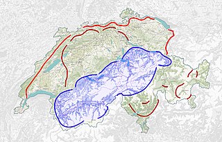
The Swiss National Redoubt is a defensive plan developed by the Swiss government beginning in the 1880s to respond to foreign invasion. In the opening years of the Second World War the plan was expanded and refined to deal with a potential German invasion. The term "National Redoubt" primarily refers to the fortifications begun in the 1880s that secured the mountainous central part of Switzerland, providing a defended refuge for a retreating Swiss Army.

The Fortified Section of Savoy(Secteur fortifié de la Savoie) was the French military organization that in 1940 controlled the section of the Alpine Line portion of the Maginot Line facing Italy in the Savoy region. The sector constituted part of the Alpine Line portion of the Maginot Line, between the Defensive Sector of the Rhône to the north, and the Fortified Sector of the Dauphiné to the south. The works combined a number of pre-1914 fortifications with Maginot-style ouvrages, with many forward-positioned cavern-style frontier stations or avant-postes that proved effective in holding invading forces near the order.

The ruins of the rock castle called Fairy Rock are located in the municipality of Crans-Montana, Valais, Switzerland, between Mollens and Aminona, more precisely in a rock face at the hamlet Les Echerts. The ruins are rather well preserved, and can be easily admired from nearby. Due to its location in the rock, however, accessing the inside is difficult. The rock castle was built at the end of the 12th century, and was probably used as a refuge during the wars and raids of that period.

