
Smyrna was an Ancient Greek city located at a strategic point on the Aegean coast of Anatolia. Due to its advantageous port conditions, its ease of defence, and its good inland connections, Smyrna rose to prominence. Since about 1930, the city's name has been İzmir.

Mudbrick or mud-brick, also known as unfired brick, is an air-dried brick, made of a mixture of mud mixed with a binding material such as rice husks or straw. Mudbricks are known from 9000 BCE.

Ekron, in the Hellenistic period known as Accaron was a Philistine city, one of the five cities of the Philistine Pentapolis, located in present-day Israel.
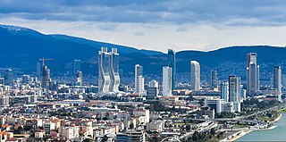
İzmir is a city on the west coast of Anatolia, and capital of İzmir Province. It is the third most populous city in Turkey, after Istanbul and Ankara, and the largest urban agglomeration on the Aegean Sea.

Pontic Olbia or simply Olbia is an archaeological site of an ancient Greek city on the shore of the Southern Bug estuary in Ukraine, near the village of Parutyne. The archaeological site is protected as the National Historic and Archaeological Preserve. The preserve is a research and science institute of the National Academy of Sciences of Ukraine. In 1938–1993 it was part of the NASU Institute of Archaeology as a department.

Konak is a municipality and district of İzmir Province, Turkey. Its area is 24 km2, and its population is 332,277 (2022). It is the most densely populated of the thirty districts of İzmir, and has historically acted as the administrative and economic core of the city. Situated in an area that roughly corresponds to the geographic center of İzmir, Konak extends for 11.4 kilometres along the southern coastline of the Gulf of İzmir. Konak district area neighbors the district areas of Bornova to the east, Balçova to the west and Buca and Karabağlar to the south. Konak center is connected to other districts of İzmir and beyond by a dense network of roads and railroads, as well as by a subway line currently being largely extended and by ferry services to Karşıyaka. Konak is a very active hub of industry, trade, commerce and services, with the number of companies exceeding sixty thousand and its exports nearing two billion US dollars in 2006.

Arslantepe, also known as Melid, was an ancient city on the Tohma River, a tributary of the upper Euphrates rising in the Taurus Mountains. It has been identified with the modern archaeological site of Arslantepe near Malatya, Turkey.
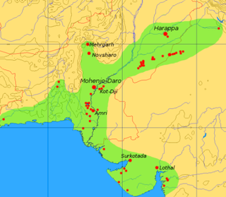
Surkotada is an archaeological site located in Rapar Taluka of Kutch district, Gujarat, India which belongs to the Indus Valley civilisation (IVC). It is a smaller fortified IVC site with 1.4 hectares in area.

The Tall Zira'a is an archaeological tell in Jordan. Surveys and geophysical investigations showed the site's great potential for excavations.
Khirbet Qeiyafa, also known as Elah Fortress and in Hebrew as Horbat Qayafa, is the site of an ancient fortress city overlooking the Valley of Elah and dated to the first half of the 10th century BCE. The ruins of the fortress were uncovered in 2007, near the Israeli city of Beit Shemesh, 30 km (20 mi) from Jerusalem. It covers nearly 2.3 ha and is encircled by a 700-meter-long (2,300 ft) city wall constructed of field stones, some weighing up to eight tons. Excavations at site continued in subsequent years. A number of archaeologists, mainly the two excavators, Yosef Garfinkel and Saar Ganor, have claimed that it might be one of two biblical cities, either Sha'arayim, whose name they interpret as "Two Gates", because of the two gates discovered on the site, or Neta'im; and that the large structure at the center is an administrative building dating to the reign of King David, where he might have lodged at some point. This is based on their conclusions that the site dates to the early Iron IIA, ca. 1025–975 BCE, a range which includes the biblical date for the biblical Kingdom of David. Others suggest it might represent either a North Israelite, Philistine, or Canaanite fortress, a claim rejected by the archaeological team that excavated the site. The team's conclusion that Khirbet Qeiyafa was a fortress of King David has been criticised by some scholars. Garfinkel (2017) changed the chronology of Khirbet Qeiyafa to ca. 1000–975 BCE.
The town of Limantepe, sometimes spelled Liman Tepe, located on Turkey's western coast is the site of a prehistoric settlement that includes an ancient port dating from 2500 years located underwater offshore. The area is situated in the urban zone of the coastal town of Urla near İzmir. In pre-classical antiquity and during the Hellenistic and Roman eras, it was a Greek town called Larisa.

Gordion was the capital city of ancient Phrygia. It was located at the site of modern Yassıhüyük, about 70–80 km (43–50 mi) southwest of Ankara, in the immediate vicinity of Polatlı district. Gordion's location at the confluence of the Sakarya and Porsuk rivers gave it a strategic location with control over fertile land. Gordion lies where the ancient road between Lydia and Assyria/Babylonia crossed the Sangarius river. Occupation at the site is attested from the Early Bronze Age continuously until the 4th century CE and again in the 13th and 14th centuries CE. The Citadel Mound at Gordion is approximately 13.5 hectares in size, and at its height habitation extended beyond this in an area approximately 100 hectares in size. Gordion is the type site of Phrygian civilization, and its well-preserved destruction level of c. 800 BCE is a chronological linchpin in the region. The long tradition of tumuli at the site is an important record of elite monumentality and burial practice during the Iron Age.
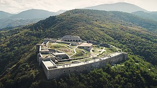
Prizren Fortress is a hilltop fortification in Prizren in Kosovo. It overlooks the Prizren River which flows through Prizren, which developed around the fortress. The site of the fortress of Prizren has seen habitation and use since the Bronze Age. In late antiquity it was part of the defensive fortification system in western Dardania and was reconstructed in the era of eastern Roman Emperor Justinian. Byzantine rule in the region ended definitively in 1219–20 as the Serbian Nemanjić dynasty controlled the fort until 1371.
Tell es-Sultan, also known as Tel Jericho or Ancient Jericho, is an archaeological site and a UNESCO World Heritage Site in Palestine, in the city of Jericho, consisting of the remains of the oldest fortified city in the world.

Tel Yokneam, also spelled Yoqne'am or Jokneam, is an archaeological site located in the northern part of the modern city of Yokneam Illit, Israel. It is known in Arabic as Tell Qamun, believed to be a corruption of the Hebrew name. The site is an elevated mound, or tell, spanning around 40 dunams and rising steeply to a height of 60 meters (200 ft). With a few brief interruptions, Yokneam was occupied for 4,000 years, from the Middle Bronze Age to the Ottoman period.

The Fortifications of Derbent (Darband) are one of the fortified defense lines, some of which date to the times as early as those built by the Persian Sasanian Empire to protect the eastern passage of the Caucasus Mountains against the attacks of the nomadic peoples of the Pontic–Caspian steppe. With the first parts built in the 6th century during the reign of Persian emperor Khosrow I and maintained by various later Arab, Turkish and Persian regimes, the fortifications comprise three distinct elements: the citadel of Naryn-Kala at Derbent, the twin long walls connecting it with the Caspian Sea in the east, and the "mountain wall" of Dagh-Bary, running from Derbent to the Caucasus foothills in the west. The immense wall, with a height of up to twenty meters and a thickness of about 10 feet, stretched for forty kilometers between the Caspian Sea and the Caucasus Mountains, thirty north-looking towers stretched for forty kilometers between the Caspian Sea and the Caucasus Mountains, effectively blocking the passage across the Caucasus. The fortification complex was made a UNESCO World Heritage Site in 2003.

Orthos was a city and polis (city-state) in Hellenistic ancient Thessaly.

The Agora of Smyrna, alternatively known as the Agora of İzmir, is an ancient Roman agora located in Smyrna. Originally built by the Greeks in the 4th century BC, the agora was ruined by an earthquake in 178 AD. Roman Emperor Marcus Aurelius ordered its reconstruction. Excavations started in 1933. In 2020, the Agora of Smyrna became a Tentative World Heritage Site as part of "The Historical Port City of Izmir."

The archaeological site at Vlochos is located at the northeast corner of the western Thessalian plain, in the regional unit of Karditsa, Greece. The site is centred around the large hill of Strongilovouni south of the modern village, and contains the remains of several urban settlements of Classical Antiquity. The remains cannot be securely identified with any city known from ancient sources, but the size of the settlement indicates that it must have been one of the poleis or city-states of the region.

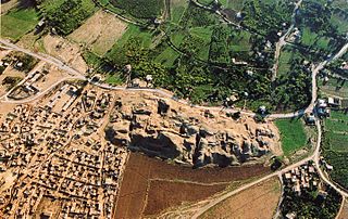
Old Smyrna is an ancient Greek exonym first known to have been applied by Strabo to a city of the endonym Σμύρνα, Smyrna. It had existed at the same location on the Bay of Smyrna, Turkey, since prehistoric times. Old Smyrna experienced what was termed dioecism (dioikismos), the removal of a city from its subordinate constituents, the reverse of synoecism, at the hands of its Lydian conquerors under their king, Alyattes, in 585 BC, in the Archaic Period of Greece. It is mentioned by Herodotus. Such a procedure, which was standard among the ancient Greeks, razes the center of the city and distributes the population to komai, or "villages,". Apparently they did not suffer andrapodismos, the massacre of the men and the sale of the women and children into slavery, but were allowed to live komedon, "in villages," albeit without a polis of their own.
