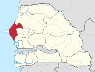
Foundiougne department

Last updated
Foundiougne
Map of the departments of the Fatick region of Senegal.png
Location in the Fatick region
CountryFlag of Senegal.svg  Senegal
Region Fatick region
Capital Foundiougne
Area
  Total
2,959 km2 (1,142 sq mi)
Population
 (2023 census) [1]
  Total
376,408
  Density130/km2 (330/sq mi)
Time zone UTC+0 (GMT)

Foundiougne department is one of the departments of Senegal, located in the Fatick region.

Contents

Economy

Foundiougne is a main hub on the Sine-Saloum river in the Fatick region of Senegal. It is a popular launch pad for eco-tours to see the abundant mangroves along the river. A ferry (connecting Foundiougne to the main road leading to Fatick) crosses the river at set times throughout the day transporting locals and tourists alike. Services that can be found include a post office, hospital, grocery stores, a pharmacy, restaurants, an internet cafe, and hotels. A high school in town serves Foundiougne and Mbam. There is a market every Tuesday (called a luma) on the edge of town, near the road to Mbam. At the weekly Luma, residents can purchase anything that they might require, ranging from plastic buckets to cooking pots to fabric to sandals to western clothing. It is an important center for residents of nearby villages, who travel to Foundiougne often on horse-drawn chariots.[ citation needed ]

Administrative divisions

There are five communes in the department: Foundiougne, Passy  [ fr ], Sokone, Soum  [ fr ] and Karang Poste  [ fr ].

The rural districts (communautés rurales) comprise:

Historic sites

Source: [2]

Foundiougne and Sokone towns
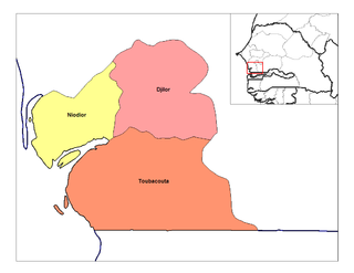
Djilor
Niodior
Toubacouta

Related Research Articles

<span class="mw-page-title-main">Thiès region</span> Region of Senegal

Thiès is a region of western Senegal. The capital is also called Thiès.

<span class="mw-page-title-main">Departments of Senegal</span>

The 14 regions of Senegal are subdivided into 46 departments and 103 arrondissements and by collectivités locales which elect administrative officers.

<span class="mw-page-title-main">Arrondissements of Senegal</span> Administrative territorial entity of Senegal

The departments of Senegal are subdivided into arrondissements. As of 2008 there were 133. The arrondissements are listed below, by department:

<span class="mw-page-title-main">Bambey department</span> Department in Diourbel Region, Senegal

Bambey department is one of the 46 departments of Senegal, one of the three making up the Diourbel region.

<span class="mw-page-title-main">Diourbel department</span> Department in Diourbel Region, Senegal

Diourbel department is one of the 46 departments of Senegal, one of the three constituting the Diourbel region.

<span class="mw-page-title-main">Fatick department</span> Department in Fatick region, Senegal

Fatick department is one of the 46 departments of Senegal, one of the three departments making up the Fatick region, and lies on the road between Mbour and Kaolack. The Fatick region is home to many Sereer people ; the Sereers are one of the major ethnic groups in Senegal and there are four Sereer dialects. At least 99% of the regional area consists Seereer, notably of Seereer Niominka people, and less than 1% of migrant Fulbe.

<span class="mw-page-title-main">Gossas department</span> Department in Fatick region, Senegal

Gossas department is one of the departments of Senegal, located in the Fatick region on the west coast.

Mamadu Diakhou Bâ, also known as Maba Jahou Bah, Ma Ba Diakhu, Ma Ba Diakho Ba, Ma Ba Jaaxu, Mabba Jaxu Ba, was a Muslim leader in West Africa during the 19th century. He was a disciple of the Tijaniyya Sufi brotherhood and became the Almami of Saloum.

The Niominka people are an ethnic group in Senegal living on the islands of the Saloum River delta. They are currently classified as a subgroup of the Serer.

<span class="mw-page-title-main">Communes of Senegal</span> Fourth-level administrative divisions in Senegal

The Communes of Senegal are the fourth-level administrative divisions in Senegal. There are some 121 communes in Senegal which have urban status, apart from 46 communes d'arrondissement in the large towns and 370 rural communities in the countryside.
<span class="mw-page-title-main">Birkilane department</span> Department in Kaffrine Region, Senegal

Birkilane department is one of the 46 departments of Senegal and is located in the Kaffrine region. It was created as part of the new region in 2008.

<span class="mw-page-title-main">Rural communities of Senegal</span> Fourth-level administrative divisions in Senegal

Rural communities (CR) are the fourth-level administrative divisions in Senegal. They are administrative subdivisions comprising the villages, but are distinct from the urban communes and municipalities concerning medium or large towns.

<span class="mw-page-title-main">Diakhao Arrondissement</span> Arrondissement in Fatick Region, Senegal

Diakhao Arrondissement is an arrondissement of the Fatick Department in the Fatick Region of Senegal. Its capital is Diakhao.
<span class="mw-page-title-main">Djilor Arrondissement</span> Arrondissement in Fatick Region, Senegal

Djilor Arrondissement is an arrondissement of the Foundiougne Department in the Fatick Region of Senegal.

<span class="mw-page-title-main">Niodior Arrondissement</span> Arrondissement in Fatick Region, Senegal

Niodior Arrondissement is an arrondissement of the Foundiougne Department in the Fatick Region of Senegal.

<span class="mw-page-title-main">Toubacouta Arrondissement</span> Arrondissement in Fatick Region, Senegal

Toubacouta Arrondissement is an arrondissement of the Foundiougne Department in the Fatick Region of Senegal.

Paoskoto is a village and rural commune in Paoskoto Arrondissement in the Nioro du Rip Department of the Kaolack Region of Senegal, located near the border with the Gambia.

Somb is a town in Senegal situated in the west of the country.

Diakhao is a small town and commune in the Fatick Region in the west of Senegal.

Loul Sessène is a village in Senegal located in the Sine-Saloum area, in the West of the country.

References

14°08′N16°28′W / 14.133°N 16.467°W / 14.133; -16.467