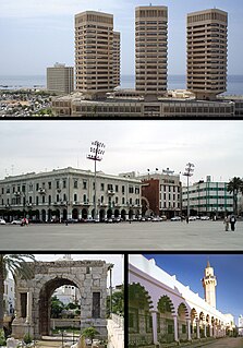
Tripolitania is a historic region and former province of Libya.
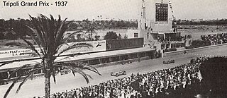
The Tripoli Grand Prix was a motor racing event first held in 1925 on a racing circuit outside Tripoli, the capital of what was then Italian Tripolitania. It lasted until 1940.
Four Points by Sheraton is a brand of hotels targeted towards business travelers and small conventions. It is owned by Starwood Hotels & Resorts, which is a subsidiary of Marriott International. The group operate more than 300 hotels worldwide under the Four Points by Sheraton brand.

Zliten is a town in Murqub District of Libya. It is located 160 km to the east of Tripoli.

Tajura, also spelt Tajoura, is a town in north-western Libya, and baladiyah in the Tripoli Muhafazah, on the Mediterranean coast 14 kilometres (8.7 mi) east of Tripoli.

The Sheraton Centre Toronto Hotel is a Sheraton 1450-room hotel in Toronto, Ontario, Canada. It is the second-tallest all-hotel building in Toronto, after the Delta Toronto Hotel.

Umayyad Square is a large and important square in Damascus, Syria. It connects the city center with several important highways and areas and contains various important buildings including but not limited to the Ministry of Defense, Syria's national Opera house and the headquarters of the Syrian Armed Forces.
Janzur or Janzour, also known as Zanzur, is a city in north-western Libya, situated on the Libyan coastline of the Mediterranean Sea, located in the west of the capital Tripoli, and East of Az-Zawiya. Residents of this city are called Janazrah.

The Red Castle Museum, also known as Assaraya Alhamra Museum or the Archaeological Museum of Tripoli, is a national museum in Libya. It is located in the historic building known as the Red Castle, or Red Saraya.
The Round of 32 for the 2009–10 Libyan Cup consists of the 14 Libyan Premier League clubs, in addition to the 18 who qualified from the previous rounds. The draw was conducted on Thursday, January 7 at LFF headquarters in Tripoli. The dates and times for the matches were decided as follows:

The Sheraton Kampala Hotel is a hotel in Kampala, the capital of Uganda and its largest city. It is one of the three Five star hotels in Kampala, as rated by the Uganda Tourism Board in June 2015.
Imperial Royale Hotel is a hotel in Kampala, Uganda's capital city.
Kampala Speke Hotel is a hotel in Kampala, the capital and largest city in Uganda, the third-largest economy in the East African Community.
Zawiyat al-Dahmani is a suburb of Tripoli, Libya. It lies between the coast to the north, and the suburb of Fashloom to the south.
Tarabulus Zoo Park is a park in Tripoli, Libya, located to the south of Tripoli city center. Tripoli Zoo is in the south-west corner of the park, and the Rixos Al Nasr hotel is situated in its south-east corner.

The Battle of Tripoli was a military confrontation in Tripoli, Libya, between loyalists of Muammar Gaddafi, the longtime leader of Libya, and the National Transitional Council, which was attempting to overthrow Gaddafi and take control of the capital. The battle began on 20 August 2011, six months after the Libyan Civil War started, with an uprising within the city; rebel forces outside the city planned an offensive to link up with elements within Tripoli, and eventually take control of the nation's capital.

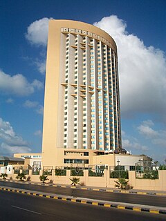
The Sheraton Tripoli Hotel is a partially-completed luxury hotel in Libya's capital Tripoli in the Gergarish District. It was incomplete when the Libyan Civil War broke out in February 2011. Construction was halted and the structure has been abandoned. It sits directly next to the Four Points by Sheraton Tripoli Hotel.
In January 2015, the Corinthia Hotel in Tripoli was attacked by men affiliated with the Islamic State of Iraq and the Levant (ISIL). The hotel was popular with foreign officials and government workers; it had previously housed the Libyan Prime Minister.