Liberia is a sub-Saharan nation in West Africa located at 6 °N, 9 °W. It borders the north Atlantic Ocean to the southwest and three other African nations on the other three sides, Sierra Leone to the northwest, Guinea to the northeast and Ivory Coast to the east.

Monrovia is the capital city of the West African country of Liberia. Founded in 1822, it is located on Cape Mesurado on the Atlantic coast, and is the country's most populous city. As of the 2008 census, with 1,010,970 residents, it was home to 29% of Liberia’s total population. Monrovia is also the country’s economic, financial and cultural center. Its economy is primarily centered on its harbor and its role as the seat of Liberia's government.

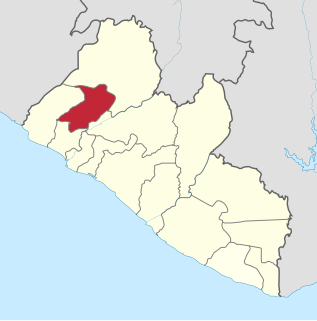
Lofa is a county in the northernmost portion of Liberia. One of 15 counties that constitute the first-level of administrative division in the nation, it has nine districts. Voinjama serves as the capital with the area of the county measuring 9,982 square kilometres (3,854 sq mi). As of the 2008 Census, it had a population of 276,863, making it the third most populous county in Liberia.
Sanniquellie is a city and the capital of Nimba County and Sanniquellie-Mahn District, Liberia. It is located in the north-east of the country at coordinates 07°21'49" N 008°42'40" W. The average altitude of the city is 420 metres above the sea level. As of the 2008 national census, the population stood at 11,415. The most represented tribes are Mano, Gio and Mandingo.

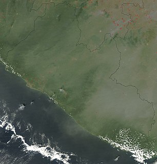
Guinée forestière is a forested mountainous region in southeastern Guinea, extending into northeastern Sierra Leone. It is one of four natural regions into which Guinea is divided and covers 23% of the country. It includes all of the Nzérékoré administrative region, and shares a border with Sierra Leone and Liberia. Its rocky topology contains several mountain ranges and has an average elevation of 460m. Forested Guinea contains important areas of biological diversity such as the UNESCO World Heritage site Mount Nimba Strict Nature Reserve and biosphere reserve Ziama Massif. The Guéckédou prefectures also recorded the initial case of the 2014 Ebola outbreak in Meliandou, a rural village. The virus subsequently spread to urban areas and neighbouring countries Sierra Leone and Liberia.

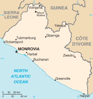
Voinjama is a small city that serves as the capital of Lofa County, Liberia and is located in the hilly, far northern part of the country near the Guinean border. As of the 2008 national census, the population stood at 26,594.
Gbarpolu is a county in the northern portion of Liberia. One of 15 counties that comprise the first-level of administrative division in the nation, it has six districts. Bopulu serves as the capital with the area of the county measuring 9,689 square kilometres (3,741 sq mi). As of the 2008 Census, it had a population of 83,758, making it the eleventh-most populous county in Liberia.

Bomi is a county in the northwestern portion of the West African nation of Liberia. The county was established in 1984. The county's area is 746 square miles (1,900 km2).

Bong is a county in the north-central portion of the West African nation of Liberia. One of 15 counties that comprise the first-level of administrative division in the nation, it has twelve districts. Gbarnga serves as the capital. The area of the county measures 8,772 square kilometres (3,387 sq mi). As of the 2008 Census, it had a population of 328,919, making it the third-most populous county in Liberia. The county was organized in 1964 and is important for its mining industry.

The United Nations Mission in Liberia (UNMIL) was a peacekeeping force established in September 2003 to monitor a ceasefire agreement in Liberia following the resignation of President Charles Taylor and the conclusion of the Second Liberian Civil War. The peacekeeping mission formally withdrew on 30 March 2018. At its peak it consisted of up to 15,000 United Nations military personnel and 1,115 police officers, along with a civilian component. It superseded the United Nations Observer Mission in Liberia (UNOMIL). As of July 2016, 1,240 U.N. military and 606 police personnel remained on the ground, but were there only in case of emergency.

Joseph Nyumah Boakai is a Liberian politician who served as Vice President of Liberia from 2006 to 2018, serving under President Ellen Johnson Sirleaf. Previously, he served as Minister of Agriculture from 1983 to 1985.

Foya District is one of six districts located in Lofa County, Liberia. Foya District is the most populous district in Lofa County, with a population of 73,312 people as of the 2008 census. Foya is predominantly occupied by the Kissi tribe. Foya is about 450 km (280 mi) from Monrovia.

Kolahun District is the largest administrative district of Lofa County in Liberia. It has an estimated population of 59,057. Kolahun was the scene of heavy fighting between government troops and rebels during Liberia's second civil war, causing massive shifts in population and destruction of property.

Voinjama District is one of six districts located in Lofa County, Liberia.
Liberia is one of the poorest countries in the world. Civil wars have killed around 250,000 people and displaced many more. The wars ended in 2003 but destroyed most of the country's healthcare facilities. Recovery proceeds but the majority of the population still live below the international poverty line. Life expectancy in Liberia is much lower than the world average. Communicable diseases are widespread, including tuberculosis, diarrhea, malaria, HIV, and Dengue. Female genital mutilation is widely practiced. Nearly a quarter of children under the age of five are malnourished and few people have access to adequate sanitation facilities. In 2009, government expenditure on health care per-capita was US$22, accounting for 10.6% of total GDP. In 2008, Liberia had only one doctor and 27 nurses per 100,000 people. It was ill-equipped to handle the outbreak of Ebola in 2014 and 2015.

The 2013–2016 outbreak of Ebola virus disease, centered in Western Africa, was the most widespread outbreak of the disease in history and caused major loss of life and socioeconomic disruption in the region, mainly in Guinea, Liberia and Sierra Leone. The first cases were recorded in Guinea in December 2013; later, the disease spread to neighbouring Liberia and Sierra Leone, with minor outbreaks occurring elsewhere. It caused significant mortality, with the case fatality rate reported which was initially considerable, while the rate among hospitalised patients was 57–59%, the final numbers 28,616 people, including 11,310 deaths, for a case-fatality rate of 40%. Small outbreaks occurred in Nigeria and Mali, and secondary infections of medical workers occurred in the United States and Spain. In addition, isolated cases were recorded in Senegal, the United Kingdom and Italy. The number of cases peaked in October 2014 and then began to decline gradually, following the commitment of substantial international resources. As of 8 May 2016, the World Health Organization (WHO) and respective governments reported a total of 28,646 suspected cases and 11,323 deaths (39.5%), though the WHO believes that this substantially understates the magnitude of the outbreak.

An Ebola virus epidemic in Sierra Leone occurred in 2014, along with the neighbouring countries of Guinea and Liberia. On March 18, 2014 Guinean health officials announced the outbreak of a mysterious hemorrhagic fever "which strikes like lightning." It was identified as Ebola virus disease and spread to Sierra Leone by May 2014. The disease was thought to have originated when a child from a bat-hunting family contracted the disease in Guinea in December 2013.
An epidemic of Ebola virus disease occurred in Liberia from 2014 to 2015, along with the neighbouring countries of Guinea and Sierra Leone. The first cases of virus were reported by late March 2014. The Ebola virus, a biosafety level four pathogen, is an RNA virus discovered in 1976.

This article covers the timeline of the 2014 Ebola virus epidemic in West Africa and its outbreaks elsewhere. Flag icons denote the first announcements of confirmed cases by the respective nation-states, their first deaths, and their first secondary transmissions, as well as relevant sessions and announcements of agencies such as the World Health Organization (WHO), the U.S. Centers for Disease Control (CDC), and NGOs such as Doctors Without Borders; medical evacuations, visa restrictions, border closures, quarantines, court rulings, and possible cases of zoonosis are also included.