
Monrovia is the capital city of the West African country of Liberia. Founded in 1822, it is located on Cape Mesurado on the Atlantic coast and as of the 2022 census had 1,761,032 residents, home to 33.5% of Liberia’s total population. Its Metro Area including Montserrado and Margibi counties largely being urbanized, was home to 2,225,911 inhabtants as of the 2022 census. As the nation's primate city, Monrovia is the country's economic, financial and cultural center; its economy is primarily centered on its harbor and its role as the seat of Liberian government.

The Liberians United for Reconciliation and Democracy (LURD) was a rebel group in Liberia that was active from 1999 until the resignation of Charles Taylor ended the Second Liberian Civil War in 2003. While the group formally dissolved after the war, the interpersonal linkages of the civil war era remain a key force in internal Liberian politics.

Montserrado County is a county in the northwestern portion of the West African nation of Liberia containing its national capital, Monrovia. One of 15 counties that comprise the first-level of administrative division in the nation, it has 17 sub political districts. As of the 2022 Census, it had a population of 1,920,914, making it the most populous county in Liberia. The area of the county measures 738.5 square miles (1,913 km2), the smallest in the country. Bensonville serves as the capital.

Lofa is a county in the northernmost portion of Liberia. One of 15 counties that constitute the first-level of administrative division in the nation, it has nine districts. Voinjama serves as the capital with the area of the county measuring 3,854 square miles (9,980 km2). As of the 2022 Census, it had a population of 367,376, making it Liberia's fourth most populous county.

Grand Cape Mount is a county in the northwestern portion of the West African nation of Liberia. One of 15 counties that constitute the first-level of administrative division in the nation, it has five districts. Robertsport serves as the capital with the area of the county measuring 1,993 square miles (5,160 km2). As of the 2008 Census, it had a population of 129,817, making it the eighth most populous county in Liberia. The county is bordered by Gbarpolu County to the northeast and Bomi County to the southeast. The northern part of Grand Cape Mount borders the nation of Sierra Leone, while to the west lies the Atlantic Ocean.

The First Liberian Civil War was the first of two civil wars within the West African nation of Liberia. It lasted from 1989 to 1997. President Samuel Doe established a regime in 1980 but totalitarianism and corruption led to unpopularity and the withdrawal of the support of the United States by the late 1980s. The National Patriotic Front of Liberia (NPFL) led by Charles Taylor invaded Liberia from the Ivory Coast to overthrow Doe in December 1989 and gained control over most of the country within a year. Doe was captured and executed by the Independent National Patriotic Front of Liberia (INPFL), a splinter faction of the NPFL led by Prince Johnson, in September 1990. The NPFL and INPFL fought each other for control of the capital city, Monrovia and against the Armed Forces of Liberia and pro-Doe United Liberation Movement of Liberia for Democracy. Peace negotiations and foreign involvement led to a ceasefire in 1995 but fighting continued until a peace agreement between the main factions occurred in August 1996. Taylor was elected President of Liberia following the 1997 Liberian general election and entered office in August of the same year.
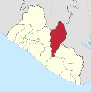
Nimba County is a county in northeastern Liberia that shares borders with the Republic of Côte d'Ivoire in the East and the Republic of Guinea in the Northwest. Its capital city is Sanniquellie and its most populous city is Ganta. With the county's area measuring 11,551 square miles (29,920 km2), Nimba is the largest of Liberia's 15 counties. The county has six statutory districts. As of the 2022 Census, it had a population of 621,841, making it the second most populous county in Liberia.
Zorzor is the second largest city in Lofa County, Liberia. Located far from Liberia's capital of Monrovia, it is a local trade center for agricultural products such as rice, cassava, pineapples, palm oil, and palm kernels. Zorzor's major ethnic groups include the Kpelle and Loma peoples. The town also contains an American Lutheran church hospital, a leper colony, and a handicrafts workshop. The Zozor Rural Teacher Training institute is located in the nearby town of Fisebu. Without motorised transport, Zorzor is approximately seven days' walk away from Monrovia. The city's first hospital was the aforementioned Lutheran facility, which was constructed in 1924; local residents were initially suspicious of Western medicinal practices, but they were ultimately convinced by thirty-one years of labor by Esther Bacon, an American nurse who worked at the hospital from 1941 until her 1972 death.

Bomi is a county in the northwestern portion of the West African nation of Liberia. The county was established in 1984. The county's area is 746 square miles (1,900 km2).

Bong is a county in the north-central portion of the West African nation of Liberia. One of 15 counties that comprise the first-level of administrative division in the nation, it has twelve districts. Gbarnga serves as the capital. The area of the county measures 8,772 square kilometres (3,387 sq mi). As of the 2022 Census, it had a population of 467,502, making it the third-most populous county in Liberia. The county was organized in 1964 and is important for its mining industry.

Margibi is a county on the north to central coast of Liberia. One of 15 counties that constitute the first-level of administrative division in the nation, it has five districts. Kakata serves as the capital with the area of the county measuring 1,010 square miles (2,600 km2). As of the 2022 Census, it had a population of 304,946, making it the fifth most populous county in Liberia.

River Gee is a county in the southern portion of Liberia. One of 15 counties that constitute the first-level of administrative division in the nation, it has six districts. Fish Town serves as the capital with the area of the county measuring 1,974 square miles (5,110 km2). As of the 2022 Census, it had a population of 124,653, making it one of the least populous counties in Liberia. It was created in 2000.
The Lofa Defense Force (LDF) was a rebel group that participated in the Liberian Civil War.

Zwedru is the capital of Grand Gedeh County, one of the 15 counties in Liberia. Zwedru is located in Tchien District of Grand Gedeh County, near the Cavalla River in the country's south-eastern region and near the border with Côte d'Ivoire. It is located 350 miles southeast from the capital city of Monrovia. The town is a stronghold of the Krahn tribe.

Zorzor District is one of six districts located in Lofa County, Liberia. Zorzor is the principal city of the county. The district is home to the city of Zorzor which serves as a prominent local trading hub for agricultural commodities like rice, cassava, pineapples, palm oil, and palm kernels. Within Zorzor, the predominant ethnic groups are the Kpelle and Loma peoples.
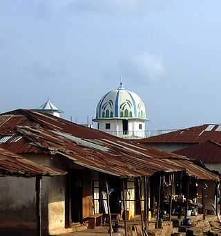
Islam in Liberia is practiced by an estimated 12.2% of the population. The vast majority of Liberian Muslims are Malikite Sunni, with sizeable Shia and Ahmadiyya minorities. The primary Muslim ethnic groups are the Vai and Mandingo but also Gbandi, Kpelle and other ethnic groups. Historically, Liberian Muslims have followed a relaxed and liberal form of Islam that is heavily influenced by indigenous religions that were integrated into Islam when it came to Liberia in the 16th century with the collapse of the Songhai Empire in Mali. Islamic religious practices vary in cities and towns across the country. Younger Liberian Muslims, particularly in the cities along the coast, tend to be more secular but still practice Islam in everyday life. In rural areas, Liberian Muslims are more conservative in dressing modestly, performing prayers and attending religious studies. The practice of Islam in Liberia has been compared to Islam common in Senegal and Gambia, with strong orientation toward Sufism.
Foya is a town in the Foya District of Lofa County, Liberia. Located 66 kilometers from Voinjama, it is home to the Kissi-speaking tribes of Liberia. Foya shares border with Sierra Leone and Guinea; it is the major trade link for the people in the far north of Lofa County. Hon William T. Kamba is the district commissioner of Foya.

Rivercess County is a county in the south-central portion of the West African nation of Liberia. One of 15 counties that compose the first-level of administrative division in the nation, it has six districts. Cesstos City serves as the capital with the area of the county measuring 2,160 square miles (5,600 km2). As of the 2008 Census, it had a population of 71,509, making it the second least populous county in Liberia after Grand Kru County.
Quardu Gboni District is an administrative district of Lofa County in Liberia. In 2008, it had a population of 18,785.


