Liberia, officially the Republic of Liberia, is a country on the West African coast. It is bordered by Sierra Leone to its northwest, Guinea to its north, Ivory Coast to its east, and the Atlantic Ocean to its south-southwest. It has a population of around 5 million and covers an area of 111,369 square kilometers (43,000 sq mi). English is the official language, but over 20 indigenous languages are spoken, representing the numerous ethnic groups who make up more than 95% of the population. The country's capital and largest city is Monrovia.

Monrovia is the capital city of the West African country of Liberia. Located on the Atlantic Coast at Cape Mesurado, Monrovia had a population of 1,010,970 as of the 2008 census. With 29% of the total population of Liberia, Monrovia is the country's most populous city.

Montserrado County is a county in the northwestern portion of the West African nation of Liberia. One of 15 counties that comprise the first-level of administrative division in the nation, it is composed of four districts. As of the 2008 Census, it had a population of 1,118,241, making it the most populous county in Liberia. The area of the county measures 1,912.7 square kilometres (738.5 sq mi), the smallest in the country. Bensonville serves as the capital.
Sanniquellie is a city and the capital of Nimba County and Sanniquellie-Mahn District, Liberia. It is located in the north-east of the country at coordinates 07°21'49" N 008°42'40" W. The average altitude of the city is 420 metres above the sea level. As of the 2008 national census, the population stood at 11,415. The most represented tribes are Mano, Gio and Mandingo.

Voinjama is a small city that serves as the capital of Lofa County, Liberia and is located in the hilly, far northern part of the country near the Guinean border. As of the 2008 national census, the population stood at 26,594.

Bomi is a county in the northwestern portion of the West African nation of Liberia. The county was established in 1984. The county's area is 746 square miles (1,900 km2).
Zwedru is the capital of Grand Gedeh County, one of the 15 counties in Liberia. Zwedru is located in Tchien District of Grand Gedeh County, near the Cavalla River in the country's south-eastern region and near the border with Côte d'Ivoire. It is located 350 miles southeast from the capital city of Monrovia. The town is a stronghold of the Krahn tribe.
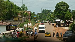
Kakata, is the capital city of Liberia's Margibi County and is located in Kakata District just over the Du River bridge which is its border with Todee District. It is a transit town at the heart of the historical natural rubber cultivation belt in Liberia. The city is colloquially known as "Kak City". The City host the Office of the National Civil Society Council of Liberia, Margibi Chapter. The Council which is headed by Mr. Friday Edwin Crusor, is known for its diligent role in Advocacy, Dialogue, and Peacebuilding among others.

The Kpelle language is spoken by the Kpelle people and is part of the Mande family of languages. Guinean Kpelle, spoken by half a million people, concentrated primarily, but not exclusively, in the forest regions of Guinea, whose capital, Nzérékoré, is the third largest city in Guinea and the largest city in the Guinée forestière region of south-eastern Guinea bordering Liberia, Ivory Coast, and Sierra Leone. Liberian Kpelle, spoken by half again as many, is currently taught in schools in Liberia.
The University of Liberia is a publicly funded institution of higher learning located in Monrovia, Liberia. Authorized by the national government in 1851, the University opened in 1862 as Liberia College. UL has four campuses; including the Capitol Hill Campus in Monrovia, Fendell campus in Louisiana, outside Monrovia, the Medical School Campus in Congo Town and the Straz-Sinje Campus located in Sinje Grand Cape Mount County. The University enrolls approximately 18,000 students and is one of the oldest institutions of higher learning in West Africa. It is accredited by the Liberian Commission on Higher Education.

Islam in Liberia is practiced by an estimated 12.2% of the population. The vast majority of Liberian Muslims are Malikite Sunni, with sizeable Shia and Ahmadiyya minorities. The primary Muslim ethnic groups are the Vai and Mandingo but also Gbandi, Kpelle and other ethnic groups. Historically, Liberian Muslims have followed a relaxed and liberal form of Islam that is heavily influenced by indigenous religions that were integrated into Islam when it came to Liberia in the 16th century with the collapse of the Songhai Empire in Mali. Islamic religious practices vary in cities and towns across the country. Younger Liberian Muslims, particularly in the cities along the coast, tend to be more secular but still practice Islam in everyday life. In rural areas, Liberian Muslims are more conservative in dressing modestly, performing prayers and attending religious studies. The practice of Islam in Liberia has been compared to Islam common in Senegal and Gambia, with strong orientation toward Sufism. The major Islamic holidays, Eid el Fitr, Ramadan and Eid al Adha, called Tabaski Day, are celebrated annually in Liberia. People have begun to go on Hajj to Mecca in recent years. Joint English-Arabic language, Quranic, and Muslim universities and Islamic studies schools have opened and been rebuilt in the capital Monrovia, rural towns and other cities. Islam appears to be experiencing revival alongside Christianity in the country as a result of the Liberian Civil War. America-Liberian Methodists, the first Christians in Liberia, arrived on January 7, 1822.
Located in the heart of Nimba County, Liberia, Saclepea was a town of more than 12,000 citizens in 2008. Saclepeans are predominantly from the native Mah tribe, and they speak the Mano dialect. During Liberia’s civil war, Saclepea was a primary recruiting and training area for child soldiers, many of whom still reside in the city. Now, Saclepea hosts one of Liberia’s regional offices of the United Nations High Commissioner for Refugees. A camp for refugees from the neighboring country of Côte d’Ivoire is situated on the outskirts of town.

Education in Liberia was severely affected by the First Liberian Civil War and Second Liberian Civil War, between 1989 and 2003. In 2010, the literacy rate of Liberia was estimated at 60.8%.
Totota is a small town in Bong County, Liberia with a population between 5,000 and 8,000 depending upon the season. The main paved road from Monrovia to Gbarnga passes through Totota keeping Totota alive with activity day and night. Totota has several high schools, notably E.J. Yancy, Upper Room, Sandary, and Lutheran. Totota, has two health clinics, Helping Hands and "Small Phebe" in addition to a myriad of churches, shops, orphanages, day cares etc. Wednesday is market day in Totota.
Careysburg is a city in Montserrado County, Liberia. It was founded in 1856, and is named in honor of Rev. Lott Carey, the first American Baptist missionary to African and a key figure in the founding of the Colony of Liberia. It is located 15 miles northeast of Monrovia.
Joseph Nargba Cooper was a Liberian politician from Bong County who held office in the third quarter of the twentieth century. Born on 16 August 1918 in the town of Gbaudi in Zorzor District, Lofa County, he was the son of Porkpa Womma and Nowai Gbanasei. After receiving his early education in a Lutheran school at Zorzor, Cooper left in 1933 to follow his brother Charlie to Kakata, where he finished his education at a Catholic mission school. Having completed his schooling, Cooper entered the employ of the Firestone Plantation Company; here he worked until 1944, when the government hired him to become a chauffeur for President Tubman. Later in his government service, Cooper was the Native Advocate for the Central Province. In 1967, Cooper was elected to fill one of Bong County's seats in the House of Representatives; he continued to occupy this office until his death, which occurred in a Bong County hospital on 22 May 1975. From 29 January 1950 until his death, Cooper was married to the former Emma L. Jensen, a native of Sanoyie; she bore him four sons and four daughters. As an adult, Cooper was affiliated with the Lutheran church.

An epidemic of Ebola virus disease occurred in Liberia from 2014 to 2015, along with the neighbouring countries of Guinea and Sierra Leone. The first cases of virus were reported by late March 2014. The Ebola virus, a biosafety level four pathogen, is an RNA virus discovered in 1976.
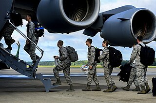
Operation United Assistance is a 2014 United States military mission to help combat the Ebola virus epidemic in West Africa, including the part of the epidemic occurring in Liberia. The 101st Airborne Division headquarters was responsible for leading the mission.
Suah Koko was an indigenous Liberian ruler who lived between the late 19th and early 20th century. She fought several battles against the expansionary Liberia Frontier Force before entering negotiations to grant accession of the territory she ruled over to the Liberian government. She later became a paramount chief and supplied porters to the Harvard Medical African Expedition (1926-1927).