Foyle Bridge

Last updated

Foyle Bridge
Foyle bridge, underside.jpg
Coordinates 55°01′07″N7°17′33″W / 55.0185°N 7.2925°W / 55.0185; -7.2925
Carries A515
Crosses River Foyle
Locale Derry
Preceded by Peace Bridge
Followed byLough Foyle Ferry
Characteristics
MaterialConcrete & Steel
History
Opened1984
Location
Foyle Bridge


The Foyle Bridge is a bridge in Derry, Northern Ireland. The central span of the bridge is the longest on the island of Ireland, at 234 metres (767 ft), and the whole suspended bridge structure including the approach spans is 866 metres long (2839 ft). [1]

Contents

It crosses the River Foyle to the north of the city, and forms only the second of three bridges linking the city centre to the Waterside, the others being the Craigavon Bridge and the Peace Bridge walkway. Work on the bridge began in 1980 and it opened in October 1984. The seven approach spans on the east bank are of pre-stressed concrete box construction. The three main river spans are of steel box construction and were built by Harland and Wolff shipyard in Belfast in 6 segments, weighed up to 900 tonnes each, and then transported by barge and oceangoing tug to site where they were lifted into position. [2] Between 2003 and 2005 the bridge underwent strengthening, resurfacing and other improvements, leading to widespread traffic disruption in the city. Total cost of the refurbishment work was £10.6 million. The road was built to four-lane dual carriageway standard, and carries the A515. By 2004 more than 30,000 vehicles used the bridge every day.

The bridge was built for the Roads Service of Northern Ireland by RDL- John Graham (Dromore) Joint Venture, with the consulting engineers being Ove Arup and Partners including D. C. Black Ltd. The value of the four-year construction contract was £15,765,000. [2] It was the first bridge in Ireland to be built according to a "Design and Construct" system, whereby the same firm designed and constructed the bridge. [3]

History

The bridge crosses the Foyle at Madam's Bank, which is the same site as King James II's army chose to place their boom barrier during the Siege of Derry in 1688–1689. [1] It is the third bridge across the River Foyle to be officially named "Foyle Bridge". The oldest Foyle Bridge still in existence, an iron railway bridge that crossed the Foyle near Porthall, a village just north of Lifford, carried the Great Northern Railway (Ireland) (the G.N.R.) line from Strabane and through The Laggan district in East Donegal. This railway line, which ran via St Johnston, had its terminus at Foyle Road in Derry. Parts of this bridge still stand. The other bridge with this name is better known as Lifford Bridge, a 1960s structure that was officially named "Foyle Bridge" when it opened. Lifford Bridge is a concrete road bridge between Lifford and Strabane.

Incidents and accidents

In 1984, while drilling the steel parapets during the bridge's construction, Kevin Ross (35), was knocked off the side into the water below when drilling equipment he was using failed, resulting in said equipment losing its magnetic base capability and hitting him in the chest. He was retrieved by standby river safety staff on duty, but unfortunately did not survive. [ citation needed ]

In January 2005 during a storm, a lorry was blown off the bridge and its driver, Peter McGuinness, killed. An investigation was launched since the storm had not been unusually severe, and it was concluded that a freak gust had contributed to the accident. However, due to the danger from cross winds, the bridge is now closed to traffic when the weather is particularly windy. Windsocks and warning signs are in place at each end to alert the drivers of HGVs. [1] [4] [5]

A new bridge management system was put in place following a review. When wind speeds reach the first trigger level of 30 mph, signs on the bridge will display an advisory speed limit of 30 mph. If the wind speeds increase to 40 mph, signs on the bridge approaches will direct high-sided vehicles to use the Craigavon Bridge instead. When the wind speed exceeds 50 mph the Foyle Bridge will be closed to all vehicles. The new system, costing £800,000, has the capacity of automatically receiving information from the wind monitoring equipment on the bridge and displaying appropriate warnings and instructions on variable message signs. These signs are located at strategic points around the city on roads leading to the Foyle Bridge and entrances to the city, including on roads leading from the Republic of Ireland. [6]

Related Research Articles

<span class="mw-page-title-main">Derry</span> City in Northern Ireland

Derry, officially Londonderry, is the largest city in County Londonderry, the second-largest in Northern Ireland and the fifth-largest on the island of Ireland. The old walled city lies on the west bank of the River Foyle, which is spanned by two road bridges and one footbridge. The city now covers both banks.

<span class="mw-page-title-main">Strabane</span> Town in County Tyrone, Northern Ireland

Strabane is a town in County Tyrone, Northern Ireland.

<span class="mw-page-title-main">Lifford</span> County town of Donegal, Ireland

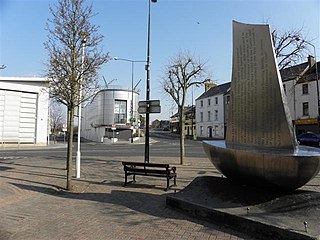
Lifford is the county town of County Donegal, Ireland, the administrative centre of the county and the seat of Donegal County Council, although the town of Letterkenny is often mistaken as holding this role.

<span class="mw-page-title-main">Lough Foyle</span> Estuary of the River Foyle, north Ireland

Lough Foyle, sometimes Loch Foyle, is the estuary of the River Foyle, on the north coast of Ireland. It lies between County Londonderry in Northern Ireland and County Donegal in the Republic of Ireland. Sovereignty over the waters has been in dispute since the Partition of Ireland.

<span class="mw-page-title-main">River Foyle</span> River in the northwest of the island of Ireland

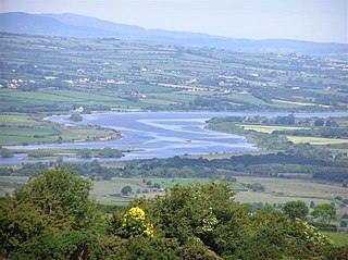
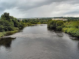
The River Foyle is a river in west Ulster in the northwest of the island of Ireland, which flows from the confluence of the rivers Finn and Mourne at the towns of Lifford in County Donegal, Republic of Ireland, and Strabane in County Tyrone, Northern Ireland. From here it flows to the city of Derry, where it discharges into Lough Foyle and, ultimately, the Atlantic Ocean. The total length of the River Foyle is 32 km (20 mi). The river separates part of County Donegal from parts of both County Londonderry and County Tyrone. The district of County Donegal that borders the western bank of the River Foyle is traditionally known as the Laggan. This district includes the villages of St Johnston and Carrigans, both of which are nestled on the banks of the River.

<span class="mw-page-title-main">County Donegal Railways Joint Committee</span>

The County Donegal Railways Joint Committee operated an extensive 3 ft narrow gauge railway system serving County Donegal, Ireland, from 1906 until 1960. The committee was incorporated by an Act of Parliament in 1906, which authorised the joint purchase of the then Donegal Railway Company by the Great Northern Railway of Ireland and the Midland Railway Northern Counties Committee.

<span class="mw-page-title-main">N13 road (Ireland)</span> Road in Ireland

The N13 road is a national primary road in Ireland, running in County Donegal in Ulster from Stranorlar to just outside Derry. This road connects Letterkenny to Sligo, Derry and onwards to other destinations.

<span class="mw-page-title-main">N14 road (Ireland)</span> Road in Ireland

The N14 road is a national primary road in the Republic of Ireland. The entirety of the route is located in the northwest of Ireland, in County Donegal, connecting Manorcunningham to Lifford in the east. Here it connects to the N15 near the border with Northern Ireland and along the A38 to Strabane in County Tyrone.

<span class="mw-page-title-main">Republic of Ireland–United Kingdom border</span>

The Republic of Ireland–United Kingdom border, sometimes referred to as the Irish border or British–Irish border, runs for 499 km (310 mi) from Lough Foyle in the north-west of Ireland to Carlingford Lough in the north-east, separating the Republic of Ireland from Northern Ireland.

<span class="mw-page-title-main">Derry ~ Londonderry railway station</span> Railway station in Northern Ireland

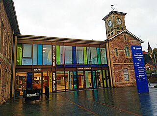
Derry ~ Londonderry railway station, also known as North West Transport Hub or Waterside railway station, is a railway terminus in Derry, Northern Ireland, on the east bank of the River Foyle, operated by Northern Ireland Railways and its 7th busiest station across the network with 952,126 passengers boarding or alighting at the station in the 2023/24 financial year. It is on the Belfast–Derry railway line, terminating at Belfast Lanyon Place. Derry/Londonderry has the longest platforms on the NIR Network, at 258.3 metres in length.

<span class="mw-page-title-main">River Finn (Foyle tributary)</span> River in Tyrone, Republic of Ireland & Northern Ireland

The River Finn is a river in the west of Ulster, the northern province in Ireland. The river mainly flows through County Donegal, part of the Republic of Ireland, while a short stretch of the river also partially flows through County Tyrone, part of Northern Ireland. From Lough Finn, the river goes to Ballybofey and Stranorlar before joining the River Mourne at Lifford and Strabane.

<span class="mw-page-title-main">Craigavon Bridge</span> Double decked bridge


The Craigavon Bridge is one of three bridges in Derry, Northern Ireland. It crosses the River Foyle further south than the Foyle Bridge and Peace Bridge. It is one of only a few double-decker road bridges in Europe. It was named after Lord Craigavon, the first Prime Minister of Northern Ireland.

<span class="mw-page-title-main">Strabane Canal</span>

The Strabane Canal is a short (6.5 km) canal in County Tyrone, Northern Ireland. It connected the market town of Strabane to the navigable River Foyle and from there to the port of Foyle Port on the north coast of Ireland. The canal opened in 1796 and closed in 1962.

Strabane Lifford Development Commission is a cross-border body in Ireland, to develop cultural and economic development ties between Strabane in County Tyrone, Northern Ireland and Lifford in County Donegal, Republic of Ireland, just across the border marked by the River Foyle.

<span class="mw-page-title-main">Lifford Bridge</span> Bridge in Ireland

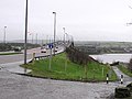
Lifford Bridge is a cross-border bridge spanning the River Foyle in Ireland. It connects Strabane in County Tyrone, Northern Ireland, and Lifford in County Donegal in the Republic of Ireland, joining the A38 road to the N15. It remains a vital part of the trans-border route from the North, West and East of County Donegal, to Dublin via County Tyrone.

<span class="mw-page-title-main">A5 road (Northern Ireland)</span>

The A5 is a major primary route in Northern Ireland. It links the city of Derry in County Londonderry with Aughnacloy, County Tyrone via the towns of Strabane and Omagh. Just south of Aughnacloy is the border with the Republic of Ireland, where the A5 meets the N2 to Dublin. Between them the A5 and N2 are the main road link between County Donegal in the Republic and Dublin.

The Londonderry and Enniskillen Railway (L&ER) was an Irish gauge railway in Ireland.

<span class="mw-page-title-main">Porthall</span> Village in County Donegal, Ireland

Porthall is a village and townland in County Donegal, Ireland. The village is located on the west bank of the River Foyle, in The Laggan district of East Donegal, on the R265 road. The nearest town is Lifford, the county town.

<span class="mw-page-title-main">City of Derry Tramways</span> Former tramway (1897-1919)

The City of Derry Tramways was a tramway in Derry, Ireland that operated from 1897 until 1919. This was a standard gauge line served by horse trams and was never electrified.

<span class="mw-page-title-main">A40 road (Northern Ireland)</span>

The A40 links Derry in the North West of Northern Ireland to Raphoe in County Donegal.

References

  1. 1 2 3 "A515 Foyle Bridge, Derry". Northern Ireland Roads Site. Retrieved 24 August 2007.
  2. 1 2 "Foyle Bridge, Londonderry" (PDF). Graham – Building for Transport. Archived from the original (PDF) on 27 September 2007. Retrieved 7 September 2013.
  3. "Foyle Bridge". Visit Derry – Places to Visit. Archived from the original on 8 August 2007. Retrieved 24 August 2007.
  4. "Lorry driver dies in bridge fall". BBC News. 11 January 2005. Retrieved 24 August 2007.
  5. "Bridge warning call after death". BBC News. 21 November 2006. Retrieved 24 August 2007.
  6. "New warning system for Foyle Bridge in high winds". Department for Regional Development – Web News. 30 June 2006. Retrieved 24 August 2007.
Next bridge upstream River Foyle Next bridge downstream
Peace Bridge (Foyle) Foyle Bridge

55°1′6.52″N7°17′32.91″W / 55.0184778°N 7.2924750°W / 55.0184778; -7.2924750