Lawrence is a city in and the county seat of Douglas County, Kansas, United States, and the sixth-largest city in the state. It is in the northeastern sector of the state, astride Interstate 70, between the Kansas and Wakarusa Rivers. As of the 2020 census, the population of the city was 94,934. Lawrence is a college town and the home to both the University of Kansas and Haskell Indian Nations University.

Bleeding Kansas, Bloody Kansas, or the Border War was a series of violent civil confrontations in Kansas Territory, and to a lesser extent in western Missouri, between 1854 and 1859. It emerged from a political and ideological debate over the legality of slavery in the proposed state of Kansas.

The sacking of Lawrence occurred on May 21, 1856, when pro-slavery settlers, led by Douglas County Sheriff Samuel J. Jones, attacked and ransacked Lawrence, Kansas, a town which had been founded by anti-slavery settlers from Massachusetts who were hoping to make Kansas a free state. The incident fueled the irregular conflict in Kansas Territory that later became known as Bleeding Kansas.
The Wakarusa War was an armed standoff that took place in the Kansas Territory during November and December 1855. It is often cited by historians as the first instance of violence during the "Bleeding Kansas" conflict between anti-slavery and pro-slavery factions in the region.

Free-Staters was the name given to settlers in Kansas Territory during the "Bleeding Kansas" period in the 1850s who opposed the expansion of slavery. The name derives from the term "free state", that is, a U.S. state without slavery. Many of the "free-staters" joined the Jayhawkers in their fight against slavery and to make Kansas a free state.

Pawnee is a ghost town in Geary County, Kansas, United States, which briefly served as the first official capital of the Kansas Territory in 1855. Pawnee was the territorial capital for exactly five days – the legislature met there from July 2 to July 6 – before legislators voted to move the capital to Shawnee Mission, which is located in present-day Fairway. It may be the shortest-lived capital of any U.S. state or territory.
The Battle of Osawatomie was an armed engagement that occurred on August 30, 1856, when 250–400 pro-slavery Border ruffians, led by John W. Reid, attacked the town of Osawatomie, Kansas, which had been settled largely by anti-slavery Free-Staters. Reid was intent on destroying the Free-State settlement and then moving on to Topeka and Lawrence to do more of the same. Abolitionist John Brown first learned of the raiders when they shot his son Frederick. With just 40 or so men, Brown tried to defend the town against the pro-slavery partisans, but ultimately was forced to withdraw; five Free-Staters were killed in the battle, and the town of Osawatomie was subsequently looted and burned by Reid's men. The battle was one of a series of violent clashes between abolitionists and pro-slavery partisans in Kansas and Missouri during the Bleeding Kansas era.

Prairie City is a ghost town in southeast Douglas County, Kansas, United States, near present-day Baldwin City.
Charles W. Dow was an early settler of the Kansas Territory who became the first American settler killed in Kansas after being shot by Franklin Coleman in 1855, an event which historians often consider the beginning of the violence of Bleeding Kansas.
In spring and possibly through summer 1864, three blockhouses were constructed to help defend the town and post of Fort Scott. These were Fort Blair, Fort Henning and Fort Insley. Fort Blair was enclosed by a rectangular wall of log palisades covered on the outside by earthworks, which in turn were surrounded by a wide, deep ditch. These were to be used by armed men and cannon in case the town and post were attacked by Confederate guerrillas or regular forces. A drawing of Fort Blair and its stockade showed the stockade as about waist high.
Caleb S. Pratt was a person involved in Bleeding Kansas. He testified before the Committee of Elections regarding the Troubles in Kansas, 1856 specific to voting irregularities in the Election of March 30, 1855 Lawrence, Kansas.

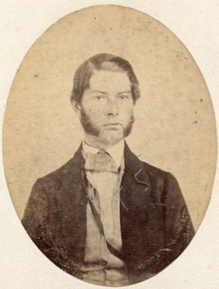
Samuel Walker was an American soldier, lawman and politician who settled in Lawrence, Kansas, and served as an officer during Bleeding Kansas and the American Civil War.
Little is known about Fort Wakarusa, which was built by free-state partisans between 1855 and 1857. Historian William E. Connelley drew a map in the 1920s that located the fort on the north side of the Wakarusa River, at Blue Jacket's Crossing. The town of Sebastian, Kansas, was on the south side of the river. Considering that the area is very flat and that there are some meander scars showing that the river has changed course various times, the site of Fort Wakarusa may today be on the south side of the river. The fort was located about midway between Lawrence, Kansas, and Eudora, Kansas.
Franklin is a ghost town in Douglas County, Kansas, United States. Established as a proslavery stronghold, the town played a key role in the "Bleeding Kansas" conflict that troubled the territory in the 1850s.
The Battle of Fort Titus occurred during conflicts in the Kansas Territory between abolitionist and pro-slavery militias prior to the American Civil War. The era is known as Bleeding Kansas.
Fort Saunders, 4 miles (6.4 km) southeast of Clinton, Kansas, and 12 miles (19 km) southwest of Lawrence, Kansas, was owned by James D. Saunders, a militia captain. What little was left of Clinton disappeared during construction of the Clinton Lake in the 1960s; only an outbuilding that was converted into a museum remains.
New Georgia's Fort was located in Miami County, Kansas, southeast of Osawatomie. During the partisan warfare in Kansas Territory in 1856 commonly known as Bleeding Kansas, a colony of Southerners, possibly all Georgians, established New Georgia. This colony was located on the Marias des Cygnes River. A blockhouse fort was constructed there and entrenchments were begun but the fort destroyed before the entrenchments could be completed. Northern settlers in the area claimed settlers at New Georgia harassed them. In reality, some settlers from both the North and South had groups who caused trouble with their neighbors.
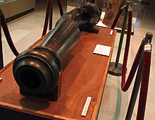
Fort Titus was the fortress residence of pro-slavery advocate Henry T. Titus, built in Kansas in April 1856, during a period when forces aligned with Titus came into conflict with free-state settlers. The wider conflict, which emerged from a political and ideological debate over the legality of slavery in the proposed state of Kansas, became known as Bleeding Kansas.
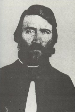
Samuel Jefferson Jones was a pro-slavery settler who held the position of Douglas County sheriff in Kansas Territory from late 1855 until early 1857. He helped found the territorial capital of Lecompton and played a prominent role in the "Bleeding Kansas" conflict.
The Stubbs were a Free-Stater militia group active in Kansas, United States during the Bleeding Kansas era. They fought in the Battle of Franklin and the capture of Fort Saunders. Along with their duties as a military defense force, the Stubbs also operated as a policing force, arresting criminals. The Stubbs had a membership of 60 on their absorption into the Union Army.