Franklin Square (Savannah, Georgia)

Last updated
Franklin Square
Franklin Square, Savannah.jpg
Franklin Square in 2017
Namesake Benjamin Franklin
Maintained byCity of Savannah
Location Savannah, Georgia, U.S.
Coordinates 32°04′52″N81°05′45″W / 32.0810°N 81.0959°W / 32.0810; -81.0959
North Montgomery Street
EastWest St. Julian Street
SouthMontgomery Street
WestWest St. Julian Street
Construction
Completion1790(234 years ago) (1790)

Franklin Square is one of the 22 squares of Savannah, Georgia, United States. It is located in the northernmost row of the city's five rows of squares, at Montgomery Street and West St. Julian Street. [1] It is west of Ellis Square in the northwestern corner of the city's grid of squares. The square now anchors the western end of the City Market retail area. [2]

Contents

The oldest building on the square is 317 West Bryan Street, the Abram Minis Building, which dates to 1846. [3]

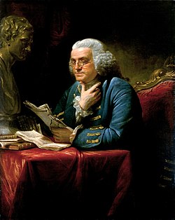
The square is named for Benjamin Franklin, one of the Founding Fathers of the United States.

It once contained a forty-foot-tall water tower to distribute water to residents. It was built with after the previous system of public and private surface wells was overwhelmed by the rising population of the city. The water was taken out of the Savannah River west of the Ogelthorpe Canal Basin before being filtered and pumped up to the water tower. [4] Because of the tower, Franklin Square was also known as Water Tank Square and Water Tower Square. It was later nicknamed Reservoir Square, [1] after an 87-foot (27 m) high reservoir which occupied the square in the 19th century. It held around 180,000 gallons of water. [5]

The square was destroyed in 1935 with the routing of U.S. Highway 17 on Montgomery Street but was restored in the mid-1980s. [1] [6] In 1967, Montgomery Street was changed from two-way to one-way between Jones and Bay streets; in 1985, however, to assist with the restoration of Franklin Square, it was restored to two-way traffic between Bay and Broughton streets. In 2019, the bi-directional traffic flow was extended from Broughton to Liberty streets. [7]

Bethel Church stood in the southwestern trust/civic block in the late 19th century. [8] It was replaced by a brick warehouse.

Sweet Georgia Brown's, a piano bar which gained popularity after its appearance in John Berendt's 1994 book Midnight in the Garden of Good and Evil , was located at 312 West St. Julian Street.
Dedication

NamesakeImageNote
Benjamin Franklin Benjamin Franklin 1767.jpg The square is named for Benjamin Franklin, one of the Founding Fathers of the United States, who served as an agent for the colony of Georgia from 1768 to 1778 and who died in 1790, the year Franklin Square was laid out. [9]

Markers and structures

ObjectImageNote
Chasseurs volontaires de Saint-Domingue (Haitian Memorial) Statues, Franklin Square.jpg A memorial honoring volunteers of Saint-Domingue, Haiti, who fought with Casimir Pulaski during the siege of Savannah, created by sculptor James Mastin, was unveiled in Franklin Square in 2007. [2] It includes a depiction of 12-year-old Henri Christophe, who became the commander of the Haitian army and King of Haiti. [2]

Constituent buildings

Each building below is in one of the eight blocks around the square composed of four residential "tything" blocks and four civic ("trust") blocks, now known as the Oglethorpe Plan. They are listed with construction years where known.

Northwestern residential/tything block
  • 418 West Bryan Street (1910) [3]
  • 420 West Bryan Street (1912) [3]
  • 14 Martin Luther King Jr. Boulevard (1891/1924) [3]
Northwestern trust/civic block
Southwestern residential/tything block
  • Augustus Walter Building, 401–405 West Congress Street (1867/1870) [3]
  • 407–415 West Congress Street (1870/1872) [3]
  • James Brannen Building, 419–423 West Congress Street (1875) – third story added 1906; roof development is 21st century
Northeastern trust/civic block
  • Abram Minis Building, 317 West Bryan Street (20–22 Montgomery Street) (1846) [3] – oldest building on the square; Vinnie Van GoGo's as of 2021
  • 301–305 West St. Julian Street (1855) [3]
  • 302 West St. Julian Street (1855) [3] – A. T. Hun Art Gallery as of 2021
  • 304 West St. Julian Street (c. 1855)
  • 310 West St. Julian Street (1884) [3]
  • 312 West St. Julian Street (1860) [3]
  • 314–316 West St. Julian Street (1870) [3]
Southeastern trust/civic block
  • Charles Lamar Properties, 305–307 West St. Julian Street (1892) [3]
  • 309–315 West St. Julian Street (1902) [3]
Southeastern residential/tything block
  • George Hardcastle Building, 30–38 Montgomery Street (1855) [3]
  • Charles Meitzler Building, 307–309 West Congress Street (1875) [3]
  • Germania Fire Company, 315 West Congress Street (1871)

Related Research Articles

The city of Savannah, Province of Georgia, was laid out in 1733, in what was colonial America, around four open squares, each surrounded by four residential "tithing") blocks and four civic ("trust") blocks. The layout of a square and eight surrounding blocks was known as a "ward." The original plan was part of a larger regional plan that included gardens, farms, and "outlying villages." Once the four wards were developed in the mid-1730s, two additional wards were laid. Oglethorpe's agrarian balance was abandoned after the Georgia Trustee period. Additional squares were added during the late 18th and 19th centuries, and by 1851 there were 24 squares in the city. In the 20th century, three of the squares were demolished or altered beyond recognition, leaving 21. In 2010, one of the three "lost" squares, Ellis, was reclaimed, bringing the total to today's 22.

<span class="mw-page-title-main">Columbia Square (Savannah, Georgia)</span> Public square in Savannah, Georgia

Columbia Square is one of the 22 squares of Savannah, Georgia, United States. It is located in the second row of the city's five rows of squares, on Habersham Street and East President Street. It is south of Warren Square and between Oglethorpe Square to the west and Greene Square to the east. The oldest building on the square is at 307 East President Street, today's 17 Hundred 90 Inn, which, as its name suggests, dates to the 18th century.

<span class="mw-page-title-main">Ellis Square (Savannah, Georgia)</span> Public square in Savannah, Georgia

Ellis Square is one of the 22 squares of Savannah, Georgia, United States. It is located in the northernmost row of the city's five rows of squares, on Barnard Street and West St. Julian Street, and was one of the first four squares laid out. Today, it marks the western end of City Market. The square is east of Franklin Square, west of Johnson Square and north of Telfair Square. The oldest building on the square is the Thomas Gibbons Range, at 102–116 West Congress Street, which dates to 1820.

<span class="mw-page-title-main">Johnson Square (Savannah, Georgia)</span> Public square in Savannah, Georgia

Johnson Square is one of the 22 squares of Savannah, Georgia, United States. Located in the northernmost row of the city's five rows of squares, it was the first of the squares to be laid out, in 1733, and remains the largest of the 22. It is east of Ellis Square, west of Reynolds Square and north of Wright Square. Situated on Bull Street and St. Julian Street, it is named for Robert Johnson, colonial governor of South Carolina and a friend of General James Oglethorpe. The oldest building on the square is the Ann Hamilton House, at 26 East Bryan Street, which dates to 1824.

<span class="mw-page-title-main">Reynolds Square (Savannah, Georgia)</span> Public square in Savannah, Georgia

Reynolds Square is one of the 22 squares of Savannah, Georgia, United States. It is located in the northernmost row of the city's five rows of squares, on Abercorn Street and East St. Julian Street. It is east of Johnson Square, west of Warren Square and north of Oglethorpe Square. The oldest building on the square is The Olde Pink House, which dates to 1771.

<span class="mw-page-title-main">Warren Square (Savannah, Georgia)</span> Public square in Savannah, Georgia

Warren Square is one of the 22 squares of Savannah, Georgia, United States. It is located in the northernmost row of the city's five rows of squares, on Habersham Street and East St. Julian Street. It is east of Reynolds Square, west of Washington Square and north of Columbia Square. The oldest building on the square is the Spencer–Woodbridge House, at 22 Habersham Street, which dates to 1790. The Lincoln Street Parking Garage occupies the entire western side of the square.

Washington Square is one of the 22 squares of Savannah, Georgia, United States. It is located in the northernmost row of the city's five rows of squares, on Houston Street and East St. Julian Street. It is east of Warren Square and north of Greene Square in the northeastern corner of the city's grid of squares, in Savannah's Old Fort neighborhood. The oldest building original to the square is 510 East St. Julian Street, which dates to 1797.

<span class="mw-page-title-main">Telfair Square (Savannah, Georgia)</span> Public square in Savannah, Georgia

Telfair Square is one of the 22 squares of Savannah, Georgia, United States. It is located in the second row of the city's five rows of squares, on Barnard Street and West President Street, and was laid out in 1733 as one of the first four squares. It is south of Ellis Square, west of Wright Square and north of Orleans Square. Liberty Square formerly stood to its west but was later paved over. The oldest building on the square is Telfair Academy, at 121 Barnard Street, which dates to 1818–1820.

<span class="mw-page-title-main">Wright Square (Savannah, Georgia)</span> Public square in Savannah, Georgia

Wright Square is one of the 22 squares of Savannah, Georgia, United States. It is located in the second row of the city's five rows of squares, on Bull Street and President Street, and was laid out in 1733 as one of the first four squares. It is south of Johnson Square, west of Oglethorpe Square, north of Chippewa Square and east of Telfair Square. The oldest building on the square is the William Waring Property, at 12 West State Street, which dates to 1825.

<span class="mw-page-title-main">Oglethorpe Square (Savannah, Georgia)</span> Public square in Savannah, Georgia

Oglethorpe Square is one of the 22 squares of Savannah, Georgia, United States. It is located in the second row of the city's five rows of squares, on Abercorn Street and East President Street, and was laid out in 1742. It is south of Reynolds Square, west of Columbia Square, north of Colonial Park Cemetery and east of Wright Square. The oldest building on the square is the Owens–Thomas House, at 124 Abercorn Street, which dates 1819.

<span class="mw-page-title-main">Chippewa Square (Savannah, Georgia)</span> Public square in Savannah, Georgia

Chippewa Square is one of the 22 squares of Savannah, Georgia, United States. It is located in the middle row of the city's five rows of squares, on Bull Street and McDonough Street, and was laid out in 1815. It is south of Wright Square, west of Colonial Park Cemetery, north of Madison Square and east of Orleans Square. The oldest building on the square is The Savannah Theatre, at 222 Bull Street, which dates to 1818.

<span class="mw-page-title-main">Pulaski Square (Savannah, Georgia)</span> Public square in Savannah, Georgia

Pulaski Square is one of the 22 squares of Savannah, Georgia, United States. It is located in the fourth row of the city's five rows of squares, on Barnard Street and West Macon Street, and was laid out in 1837. It is south of Orleans Square, west of Madison Square and north of Chatham Square. It is known for its live oaks. The oldest buildings on the square are the Theodosius Bartow House and the Bernard Constantine House, which date to 1839.

<span class="mw-page-title-main">Madison Square (Savannah, Georgia)</span> Public square in Savannah, Georgia

Madison Square is one of the 22 squares of Savannah, Georgia, United States. It is located in the fourth row of the city's five rows of squares, on Bull Street and Macon Street, and was laid out in 1837. It is south of Chippewa Square, west of Lafayette Square, north of Monterey Square and east of Pulaski Square. The square is named for James Madison, fourth president of the United States. The oldest building on the square is the Sorrel–Weed House, at 6 West Harris Street, which dates to 1840.

<span class="mw-page-title-main">Lafayette Square (Savannah, Georgia)</span> Public square in Savannah, Georgia

Lafayette Square is one of the 22 squares of Savannah, Georgia, United States. It is located in the fourth row of the city's five rows of squares, on Abercorn Street and East Macon Street, and was laid out in 1837. It is south of Colonial Park Cemetery, west of Troup Square, north of Taylor Square and east of Madison Square. The square is named for Gilbert du Motier, Marquis de Lafayette, the French hero of the American Revolution who visited Savannah in 1825. The oldest building on the square is the Andrew Low Carriage House, at 329 Abercorn Street, which dates to 1849.

<span class="mw-page-title-main">Troup Square (Savannah, Georgia)</span> Public square in Savannah, Georgia

Troup Square is one of the 22 squares of Savannah, Georgia, United States. It is located in the fourth row of the city's five rows of squares, on Habersham Street and East Macon Street, and was laid out in 1837. It is south of Colonial Park Cemetery, east of Lafayette Square and north of Whitefield Square. The square is named for George Troup, the former Georgia governor, Congressman and senator. It is one of only two Savannah squares named for a person living at the time, the other being Washington Square.

<span class="mw-page-title-main">Chatham Square (Savannah, Georgia)</span> Public square in Savannah, Georgia

Chatham Square is one of the 22 squares of Savannah, Georgia, United States. It is located in the southernmost row of the city's five rows of squares, on Barnard Street and West Wayne Street, and was laid out in 1847. It is south of Pulaski Square and west of Monterey Square in the southwestern corner of the city's grid of squares. The square is named for William Pitt, 1st Earl of Chatham. Although Pitt never visited Savannah, he was an early supporter of the Georgia colony, and both Chatham Square and Chatham County are named in his honor. The oldest building on the square is the Enoch Hendry Row House, at 108–112 West Taylor Street, which dates to 1851.

<span class="mw-page-title-main">Whitefield Square (Savannah, Georgia)</span> Public square in Savannah, Georgia

Whitefield Square is one of the 22 squares of Savannah, Georgia, United States. It is located in the southernmost row of the city's five rows of squares, on Habersham Street and East Wayne Street, and was the final square laid out, in 1851. It is south of Troup Square and east of Taylor Square in the southeastern corner of Savannah's grid of squares. The oldest building on the square is at 412–414 East Taylor Street, which dates to 1855.

<span class="mw-page-title-main">Abraham Minis (born 1820)</span> American merchant (1820–1889)

Abraham Minis was an American merchant, prominent in Savannah, Georgia, in the 19th century.

<span class="mw-page-title-main">Congress Street (Savannah, Georgia)</span> Prominent street in Savannah, Georgia

Congress Street is a prominent street in Savannah, Georgia, United States. Located between Bryan Street to the north and Broughton Street to the south, it runs for about 0.76 miles (1.22 km) from Martin Luther King Jr. Boulevard in the west, through the city's City Market, to East Broad Street in the east. Originally known only as Congress Street singular, its addresses are now split between "West Congress Street" and "East Congress Street", the transition occurring at Bull Street in the center of the downtown area. The street is entirely within Savannah Historic District, a National Historic Landmark District.

<span class="mw-page-title-main">Abram Minis Building</span> Historic house in Savannah, Georgia

The Abram Minis Building is a historic building in Savannah, Georgia, United States. Located in the northeastern trust block of Franklin Square, at 317 West Bryan Street and 20–22 Montgomery Street, it dates to 1846, making it the oldest extant building on the square. It was built as a commercial property for 26-year-old Abraham Minis, a prominent merchant of the city and founder of A. Minis & Sons.

References

  1. 1 2 3 "Franklin Square". Visit-Historic-Savannah.com. Visit-Historic-Savannah.com. Retrieved 21 February 2016.
  2. 1 2 3 "Franklin Square - Savannah, GA". Savannah.com. Savannah.com. Retrieved 21 February 2016.
  3. 1 2 3 4 5 6 7 8 9 10 11 12 13 14 15 16 17 Historic Building Map: Savannah Historic District – Historic Preservation Department of the Chatham County-Savannah Metropolitan Planning Commission (November 17, 2011), p. 4
  4. Fraser, Walter (2005). Savannah in the Old South. University of Georgia Press. p. 295. ISBN   082032776X . Retrieved 21 February 2016.
  5. "Image 3 of Sanborn Fire Insurance Map from Savannah, Chatham County, Georgia". Library of Congress, Washington, D.C. 20540 USA. Retrieved 2024-02-17.
  6. "Squares of Savannah" (PDF). CityWalkingGuide.com. Retrieved 21 February 2016.
  7. staff, City of Savannah Municipal Archives. "Savannah archives: Increased traffic, I-16 impacted Savannah Squares, city's westside residents". Savannah Morning News. Retrieved 2022-04-08.
  8. "Image 3 of Sanborn Fire Insurance Map from Savannah, Chatham County, Georgia". Library of Congress, Washington, D.C. 20540 USA. Retrieved 2024-02-17.
  9. "Virtual Historic Savannah Project: Franklin Ward". Virtual Historic Savannah Project. Savannah College of Art and Design. Retrieved 21 February 2016.