The city of Savannah, Province of Georgia, was laid out in 1733, in what was colonial America, around four open squares, each surrounded by four residential "tithing") blocks and four civic ("trust") blocks. The layout of a square and eight surrounding blocks was known as a "ward." The original plan was part of a larger regional plan that included gardens, farms, and "outlying villages." Once the four wards were developed in the mid-1730s, two additional wards were laid. Oglethorpe's agrarian balance was abandoned after the Georgia Trustee period. Additional squares were added during the late 18th and 19th centuries, and by 1851 there were 24 squares in the city. In the 20th century, three of the squares were demolished or altered beyond recognition, leaving 21. In 2010, one of the three "lost" squares, Ellis, was reclaimed, bringing the total to today's 22.

The Savannah Historic District is a large urban U.S. historic district that roughly corresponds to the pre–Civil War city limits of Savannah, Georgia. The area was declared a National Historic Landmark District in 1966, and is one of the largest urban, community-wide historic preservation districts in the United States. The district was established in recognition of the Oglethorpe Plan, a unique model of urban planning begun in 1733 by James Oglethorpe at Savannah's founding and propagated during the first century of the city's growth.

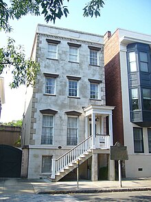
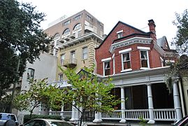
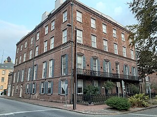
The Andrew Low House is a home in Savannah, Georgia, United States. Located at 329 Abercorn Street, in Lafayette Square, it was built by John S. Norris in 1849 and is part of the Savannah Historic District and of the Juliette Gordon Low Historic District. It is the oldest building on Lafayette Square.

Marist Place is the former location of a school building at today's 123 East Charlton Street in Savannah, Georgia, United States, in the southwest tything block of Lafayette Square. It was located in what became Savannah's Historic District.

330 Drayton Street is a building in Savannah, Georgia, United States. Located on Drayton Street, in Lafayette Square, it was built around 1849 and is part of the Savannah Historic District and of the Juliette Gordon Low Historic District.

Greene Square is one of the 22 squares of Savannah, Georgia, United States. It is the easternmost square in the second row of the city's five rows of squares. The square is located on Houston Street and East President Street, and is south of Washington Square, east of Columbia Square and north of Crawford Square. The oldest buildings on the square are at 510 East York Street, 509 East President Street and 503 East President Street, each in the southwestern trust/civic block, which are believed to have been built at the same time as the square itself (1799).

Johnson Square is one of the 22 squares of Savannah, Georgia, United States. Located in the northernmost row of the city's five rows of squares, it was the first of the squares to be laid out, in 1733, and remains the largest of the 22. It is east of Ellis Square, west of Reynolds Square and north of Wright Square. Situated on Bull Street and St. Julian Street, it is named for Robert Johnson, colonial governor of South Carolina and a friend of General James Oglethorpe. The oldest building on the square is the Ann Hamilton House, at 26 East Bryan Street, which dates to 1824.

Reynolds Square is one of the 22 squares of Savannah, Georgia, United States. It is located in the northernmost row of the city's five rows of squares, on Abercorn Street and East St. Julian Street. It is east of Johnson Square, west of Warren Square and north of Oglethorpe Square. The oldest building on the square is The Olde Pink House, which dates to 1771.

Oglethorpe Square is one of the 22 squares of Savannah, Georgia, United States. It is located in the second row of the city's five rows of squares, on Abercorn Street and East President Street, and was laid out in 1742. It is south of Reynolds Square, west of Columbia Square, north of Colonial Park Cemetery and east of Wright Square. The oldest building on the square is the Owens–Thomas House, at 124 Abercorn Street, which dates 1819.

Chippewa Square is one of the 22 squares of Savannah, Georgia, United States. It is located in the middle row of the city's five rows of squares, on Bull Street and McDonough Street, and was laid out in 1815. It is south of Wright Square, west of Colonial Park Cemetery, north of Madison Square and east of Orleans Square. The oldest building on the square is The Savannah Theatre, at 222 Bull Street, which dates to 1818.
Crawford Square is one of the 22 squares of Savannah, Georgia, United States. It is located in the middle row of the city's five rows of squares, on Houston Street and East McDonough Street, and was laid out in 1841. It is south of Greene Square and east of Colonial Park Cemetery on the eastern edge of the Savannah Historic District. The oldest building on the square is at 224 Houston Street, which dates to 1850.

Pulaski Square is one of the 22 squares of Savannah, Georgia, United States. It is located in the fourth row of the city's five rows of squares, on Barnard Street and West Macon Street, and was laid out in 1837. It is south of Orleans Square, west of Madison Square and north of Chatham Square. It is known for its live oaks. The oldest buildings on the square are the Theodosius Bartow House and the Bernard Constantine House, which date to 1839.

Madison Square is one of the 22 squares of Savannah, Georgia, United States. It is located in the fourth row of the city's five rows of squares, on Bull Street and Macon Street, and was laid out in 1837. It is south of Chippewa Square, west of Lafayette Square, north of Monterey Square and east of Pulaski Square. The square is named for James Madison, fourth president of the United States. The oldest building on the square is the Sorrel–Weed House, at 6 West Harris Street, which dates to 1840.

Troup Square is one of the 22 squares of Savannah, Georgia, United States. It is located in the fourth row of the city's five rows of squares, on Habersham Street and East Macon Street, and was laid out in 1837. It is south of Colonial Park Cemetery, east of Lafayette Square and north of Whitefield Square. The square is named for George Troup, the former Georgia governor, Congressman and senator. It is one of only two Savannah squares named for a person living at the time, the other being Washington Square.
Taylor Square, formerly known as Calhoun Square, is one of the 22 squares of Savannah, Georgia, United States. Laid out in 1851 south of Lafayette Square, west of Whitefield Square, and east of Monterey Square, it is named in honor of the first American Civil War black nurse, educator and memoirist, Susie King Taylor.
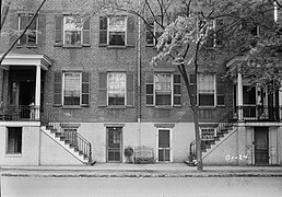
The Mary Marshall Houses is a duplex building in Savannah, Georgia, United States. It is located in the southwestern civic block of Oglethorpe Square and was built in the 1840s as rental property for Mary Marshall. It is part of the Savannah Historic District.

Abercorn Street is a prominent street in Savannah, Georgia, United States. Located between Drayton Street to the west and Lincoln Street to the east, it runs for about 7.8 miles (12.6 km) from East Bay Street in the north to Harry S. Truman Parkway in the south. It is concurrent with SR 204 from 37th Street south. The street is named for James Hamilton, 6th Earl of Abercorn, a financial benefactor of the Georgia colony. Its northern section passes through the Savannah Historic District, a National Historic Landmark District.

Drayton Street is a prominent street in Savannah, Georgia, United States. Located between Bull Street to the west and Abercorn Street to the east, it runs for about 2 miles (3.2 km) from East Bay Street in the north to East Victory Drive in the south. It is named for Ann Drayton, a member of a noted family in Charleston, South Carolina, who had lent four sawyers to assist colonists in building one of the first homes in Savannah. The street is one-way (northbound). Its northern section passes through the Savannah Historic District, a National Historic Landmark District.
Charlton Street is a prominent street in Savannah, Georgia, United States. Located between Harris Street to the north and Jones Street to the south, it runs for about 0.86 miles (1.38 km) from Purse Street in the west to East Broad Street in the east. Originally known only as Charlton Street singular, its addresses are now split between "West Charlton Street" and "East Charlton Street", the transition occurring at Bull Street in the center of the downtown area. The street is named for Thomas Charlton, fifteenth mayor of Savannah.

Harris Street is a prominent street in Savannah, Georgia, United States. Located between Liberty Street to the north and Charlton Street to the south, it runs for about 0.86 miles (1.38 km) from Purse Street in the west to East Broad Street in the east. Originally known only as Gordon Street Harris, its addresses are now split between "West Harris Street" and "East Harris Street," the transition occurring at Bull Street in the center of the downtown area. The street is named for Charles Harris, former mayor of Savannah. The street is entirely within Savannah Historic District, a National Historic Landmark District.