Crawford Square (Savannah, Georgia)

Last updated
Crawford Square
242 Price Street Warehouse, Savannah, Chatham County, Georgia.jpg
242 Price Street, now demolished
Namesake William Harris Crawford
Maintained by City of Savannah
Location Savannah, Georgia, U.S.
Coordinates 32°04′27″N81°05′12″W / 32.0742°N 81.0868°W / 32.0742; -81.0868 Coordinates: 32°04′27″N81°05′12″W / 32.0742°N 81.0868°W / 32.0742; -81.0868
North Houston Street
East East McDonough Street
South Houston Street
West East McDonough Street
Construction
Completion 1841(181 years ago) (1841)

Crawford Square is one of the 22 squares of Savannah, Georgia, United States. It is located in the middle row of the city's five rows of squares, on Houston Street and East McDonough Street, and was laid out in 1841. It is south of Greene Square and east of Colonial Park Cemetery on the eastern edge of the Savannah Historic District. [1] The oldest building on the square is at 224 Houston Street, which dates to 1850. [2]

Contents

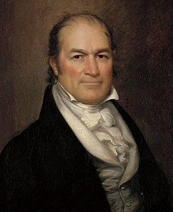
Crawford Square is named in honor of Secretary of the Treasury William Harris Crawford, born in Amherst County, Virginia, in 1772. [3] Crawford ran for the U.S. presidency in 1824 but came in third, after winner John Quincy Adams and runner-up Andrew Jackson. [4]

Although Crawford is the smallest of the squares, it anchors the largest ward, as Crawford Ward includes the territory of Colonial Park Cemetery. [5]

During the era of Jim Crow, this was the only square in which African-Americans were permitted. [5]

The square contains playground facilities, a basketball court, and a gazebo. [6]

While all squares were once fenced, it is the only one that remains so. Crawford Square has also retained its cistern, a holdover from early fire fighting practices. [5] After a major fire in 1820 firemen maintained duty stations in the squares, each of which was equipped with a storage cistern. [7]

The Lady Chablis lived in the square prior to her rise to fame after her appearance in John Berendt's non-fiction novel Midnight in the Garden of Good and Evil . [8]

Dedication

Constituent buildings

Each building below is in one of the eight blocks around the square composed of four residential "tything" blocks and four civic ("trust") blocks, now known as the Oglethorpe Plan. They are listed with construction years where known.

Northwestern civic/trust lot
  • 225 Houston Street [2]
  • 504–508 East McDonough Street [2]
  • 510 East McDonough Street [2]
Southwestern civic/trust lot
  • 227–231 Houston Street [2]
  • 501–503 East McDonough Street (1890) [2]
  • 505–507 East McDonough Street (1890) [2]
  • 232 Price Street [2]
Southwestern residential/tything lot
  • 505–515 East Perry Street (1852) [2]
  • James Roberts Row House, 517–523 East Perry Street (1871) [2]
  • 234–244 Price Street (1855) [2]
Northeastern residential/tything lot
  • 214–222 Houston Street (1910) [2]
  • 415 East Hull Street [2]
  • 215 East Broad Street [2]
Northeastern civic/trust lot
  • John Tucker Property, 224 Houston Street (1850) [2] – oldest building on the square
  • 548–550 East McDonough Street (1870) [2] – the Present Hotel (as of 2022)
  • 221 East Broad Street [2]
Southeastern civic/trust lot
  • 230 Houston Street [2]
  • 543 East McDonough Street [2]
  • 540–544 East Perry Street [2]
  • 227–229 East Broad Street [2]
Southeastern residential/tything lot
  • 531 East Perry Street [2]
  • 533–539 East Perry Street [2]
  • 543–547 East Perry Street [2]
  • 235–239 East Broad Street (1890) [2]
  • 241–243 East Broad Street (1895) [2]
  • 539 East Perry Lane [2]

Related Research Articles

Squares of Savannah, Georgia Part of the Oglethorpe Plan

The city of Savannah, Province of Georgia, was laid out in 1733, in what was colonial America, around four open squares, each surrounded by four residential ("tything") blocks and four civic ("trust") blocks. The layout of a square and eight surrounding blocks was known as a "ward." The original plan was part of a larger regional plan that included gardens, farms, and "out-lying villages." Once the four wards were developed in the mid-1730s, two additional wards were laid. Oglethorpe's agrarian balance was abandoned after the Georgia Trustee period. Additional squares were added during the late 18th and 19th centuries, and by 1851 there were 24 squares in the city. In the 20th century, three of the squares were demolished or altered beyond recognition, leaving 21. In 2010, one of the three "lost" squares, Ellis, was reclaimed, bringing the total to today's 22.

Greene Square (Savannah, Georgia) Public square in Savannah, Georgia

Greene Square is one of the 22 squares of Savannah, Georgia, United States. It is the easternmost square in the second row of the city's five rows of squares. The square is located on Houston Street and East President Street, and is south of Washington Square, east of Columbia Square and north of Crawford Square. The oldest buildings on the square are at 510 East York Street, 509 East President Street and 503 East President Street, each in the southwestern trust/civic block, which are believed to have been built at the same time as the square itself (1799).

Columbia Square (Savannah, Georgia) Public square in Savannah, Georgia

Columbia Square is one of the 22 squares of Savannah, Georgia, United States. It is located in the second row of the city's five rows of squares, on Habersham Street and East President Street. It is south of Warren Square and between Oglethorpe Square to the west and Greene Square to the east. The oldest building on the square is at 307 East President Street, today's 17 Hundred 90 Inn, which, as its name suggests, dates to the 18th century.

Ellis Square (Savannah, Georgia) Public square in Savannah, Georgia

Ellis Square is one of the 22 squares of Savannah, Georgia, United States. It is located in the northernmost row of the city's five rows of squares, on Barnard Street and West St. Julian Street, and was one of the first four squares laid out. Today, it marks the western end of City Market. The square is east of Franklin Square, west of Johnson Square and north of Telfair Square. The oldest building on the square is the Thomas Gibbons Range, at 102–116 West Congress Street, which dates to 1820.

Johnson Square (Savannah, Georgia) Public square in Savannah, Georgia

Johnson Square is one of the 22 squares of Savannah, Georgia, United States. Located in the northernmost row of the city's five rows of squares, it was the first of the squares to be laid out, in 1733, and remains the largest of the 22. It is east of Ellis Square, west of Reynolds Square and north of Wright Square. Situated on Bull Street and St. Julian Street, it is named for Robert Johnson, colonial governor of South Carolina and a friend of General James Oglethorpe. The oldest building on the square is 26 East Bryan Street, which dates to 1824.

Reynolds Square (Savannah, Georgia) Public square in Savannah, Georgia

Reynolds Square is one of the 22 squares of Savannah, Georgia, United States. It is located in the northernmost row of the city's five rows of squares, on Abercorn Street and East St. Julian Street. It is east of Johnson Square, west of Warren Square and north of Oglethorpe Square. The oldest building on the square is The Olde Pink House, which dates to 1771.

Warren Square (Savannah, Georgia) Public square in Savannah, Georgia

Warren Square is one of the 22 squares of Savannah, Georgia, United States. It is located in the northernmost row of the city's five rows of squares, on Habersham Street and East St. Julian Street. It is east of Reynolds Square, west of Washington Square and north of Columbia Square. The oldest building on the square is the Spencer–Woodbridge House, at 22 Habersham Street, which dates to 1790. The Lincoln Street Parking Garage occupies the entire western side of the square.

Washington Square is one of the 22 squares of Savannah, Georgia, United States. It is located in the northernmost row of the city's five rows of squares, on Houston Street and East St. Julian Street. It is east of Warren Square and north of Greene Square in the northeastern corner of the city's grid of squares. The oldest building original to the square is 510 East St. Julian Street, which dates to 1797.

Telfair Square (Savannah, Georgia) Public square in Savannah, Georgia

Telfair Square is one of the 22 squares of Savannah, Georgia, United States. It is located in the second row of the city's five rows of squares, on Barnard Street and West President Street, and was laid out in 1733 as one of the first four squares. It is south of Ellis Square, west of Wright Square and north of Orleans Square. Liberty Square formerly stood to its west but was later paved over. The oldest building on the square is Telfair Academy, at 121 Barnard Street, which dates to 1818–1820.

Wright Square (Savannah, Georgia) Public square in Savannah, Georgia

Wright Square is one of the 22 squares of Savannah, Georgia, United States. It is located in the second row of the city's five rows of squares, on Bull Street and President Street, and was laid out in 1733 as one of the first four squares. It is south of Johnson Square, west of Oglethorpe Square, north of Chippewa Square and east of Telfair Square. The oldest building on the square is the William Waring Property, at 12 West State Street, which dates to 1825.

Oglethorpe Square (Savannah, Georgia) Public square in Savannah, Georgia

Oglethorpe Square is one of the 22 squares of Savannah, Georgia, United States. It is located in the second row of the city's five rows of squares, on Abercorn Street and East President Street, and was laid out in 1742. It is south of Reynolds Square, west of Columbia Square, north of Colonial Park Cemetery and east of Wright Square. The oldest building on the square is the Owens–Thomas House, at 124 Abercorn Street, which dates 1819.

Orleans Square (Savannah, Georgia) Public square in Savannah, Georgia

Orleans Square is one of the 22 squares of Savannah, Georgia, United States. It is located in the middle row of the city's five rows of squares, on Barnard Street and West McDonough Street, and was laid out in 1815, shortly after the event it commemorates: General Andrew Jackson's victory at the Battle of New Orleans that January. It is south of Telfair Square, west of Chippewa Square and north of Pulaski Square. The oldest building on the square is the John Ash House, at 114–116 West Hull Street, which dates to 1817.

Chippewa Square (Savannah, Georgia) Public square in Savannah, Georgia

Chippewa Square is one of the 22 squares of Savannah, Georgia, United States. It is located in the middle row of the city's five rows of squares, on Bull Street and McDonough Street, and was laid out in 1815. It is south of Wright Square, west of Colonial Park Cemetery, north of Madison Square and east of Orleans Square. The oldest building on the square is The Savannah Theatre, at 222 Bull Street, which dates to 1818.

Pulaski Square (Savannah, Georgia) Public square in Savannah, Georgia

Pulaski Square is one of the 22 squares of Savannah, Georgia, United States. It is located in the fourth row of the city's five rows of squares, on Barnard Street and West Macon Street, and was laid out in 1837. It is south of Orleans Square, west of Madison Square and north of Chatham Square. It is known for its live oaks. The oldest buildings on the square are the Theodosius Bartow House and the Bernard Constantine House, which date to 1839.

Madison Square (Savannah, Georgia) Public square in Savannah, Georgia

Madison Square is one of the 22 squares of Savannah, Georgia, United States. It is located in the fourth row of the city's five rows of squares, on Bull Street and Macon Street, and was laid out in 1837. It is south of Chippewa Square, west of Lafayette Square, north of Monterey Square and east of Pulaski Square. The square is named for James Madison, fourth president of the United States. The oldest building on the square is the Sorrel–Weed House, at 6 West Harris Street, which dates to 1840.

Lafayette Square (Savannah, Georgia) Public square in Savannah, Georgia

Lafayette Square is one of the 22 squares of Savannah, Georgia, United States. It is located in the fourth row of the city's five rows of squares, on Abercorn Street and East Macon Street, and was laid out in 1837. It is south of Colonial Park Cemetery, west of Troup Square, north of Calhoun Square and east of Madison Square. The square is named for Gilbert du Motier, Marquis de Lafayette, the French hero of the American Revolution who visited Savannah in 1825. The oldest building on the square is the Andrew Low Carriage House, at 329 Abercorn Street, which dates to 1849.

Troup Square (Savannah, Georgia) Public square in Savannah, Georgia

Troup Square is one of the 22 squares of Savannah, Georgia, United States. It is located in the fourth row of the city's five rows of squares, on Habersham Street and East Macon Street, and was laid out in 1837. It is south of Colonial Park Cemetery, east of Lafayette Square and north of Whitefield Square. The square is named for George Troup, the former Georgia governor, Congressman and senator. It is one of only two Savannah squares named for a person living at the time.

Monterey Square (Savannah, Georgia) Public square in Savannah, Georgia

Monterey Square is one of the 22 squares of Savannah, Georgia, United States. It is located in the southernmost row of the city's five rows of squares, on Bull Street and Wayne Street, and was laid out in 1847. It is south of Madison Square, west of Calhoun Square, north of Forsyth Park and east of Chatham Square. The oldest building on the square is the Herman Kuhlman Duplex, at 22–24 West Taylor Street, which dates to 1851.

Calhoun Square (Savannah, Georgia) Public square in Savannah, Georgia

Calhoun Square is one of the 22 squares of Savannah, Georgia, United States. It is located in the southernmost row of the city's five rows of squares, on Abercorn Street and East Wayne Street, and was laid out in 1851. It is south of Lafayette Square, west of Whitefield Square and east of Monterey Square. The oldest buildings on the square are at 102 East Taylor Street and 118–122 East Taylor Street, both of which date to 1853.

Whitefield Square (Savannah, Georgia) Public square in Savannah, Georgia

Whitefield Square is one of the 22 squares of Savannah, Georgia, United States. It is located in the southernmost row of the city's five rows of squares, on Habersham Street and East Wayne Street, and was the final square laid out, in 1851. It is south of Troup Square and east of Calhoun Square in the southeastern corner of Savannah's grid of squares. The oldest building on the square is at 412–414 East Taylor Street, which dates to 1855.

References

  1. Coastal Travel Guide's ‘’Savannah Squares’‘, accessed June 16, 2007.
  2. 1 2 3 4 5 6 7 8 9 10 11 12 13 14 15 16 17 18 19 20 21 22 23 24 25 26 27 Historic Building Map: Savannah Historic District – Historic Preservation Department of the Chatham County-Savannah Metropolitan Planning Commission (November 17, 2011), p. 42
  3. SavannahBest.com's Squares of Savannah, accessed June 16, 2007
  4. The Savannah Experience, Historic Savannah Squares, accessed June 16, 2007
  5. 1 2 3 Tour Guide Manual for licensed tour guides in the City of Savannah, accessed June 16, 2007.
  6. Savannah Scene magazine, May–June 2007, pp 10–11, accessed June 16, 2007.
  7. Chan Sieg (1984). The squares: an introduction to Savannah. Virginia Beach: Donning.
  8. "A Square as Reminder of Jim Crow Days". Freeman's Rag. Retrieved 2022-03-30.