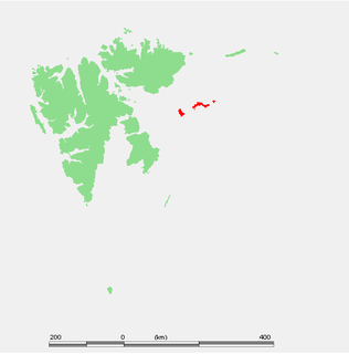
Kongsøya is an island in Svalbard, Norway. It is the largest of the islands in King Charles Land. Its area is 191 square kilometres (74 sq mi). The other main island in the chain is Svenskøya.

Hinlopen Strait is the strait between Spitsbergen and Nordaustlandet in Svalbard, Norway. It is 150 kilometers (93 mi) long and 10 to 60 kilometers wide. The strait is difficult to pass because of pack ice. It is believed to have been named after Thijmen Jacobsz Hinlopen.
Lomfjordhalvøya is a peninsula at the northeastern part of Ny-Friesland on Spitsbergen, Svalbard. It is located between Lomfjorden and Hinlopen Strait. Former names of the peninsula include Terre Margareta and Margaretas Land. The peninsula is covered by two glaciers, Balderfonna and Torsfonna. It also includes the large nesting cliffs of Lovénberget.

Nordkappsundet is a 10-15 km wide strait between Chermsideøya off the north of Nordaustlandet in the south and Sjuøyane in the north, Svalbard in Arctic Norway. Named after Nordkapp on Chermsideøya, the northern extreme of mainland Svalbard.
St. Jonsfjorden is a fjord in Oscar II Land at Spitsbergen, Svalbard. It has a length of 21 kilometer, and opens westwards into the strait of Forlandsundet. Several glaciers debouche into the fjord, including Gaffelbreen and Konowbreen from the north, a merge of Osbornebreen, Devikbreen, Vintervegen, Paulbreen and Bukkebreen at the bottom, and Vegardbreen, Charlesbreen and Bullbreen from the south.
Glenhalvøya is a peninsula in Orvin Land at Nordaustlandet, Svalbard, between Finn Malmgren Fjord and Duvefjorden. It is named after Arctic explorer Alexander Richard Glen. The island of Søre Repøya is separated from the peninsula by the strait of Gilessundet.
Murchisonfjorden is a fjord in Gustav V Land at Nordaustlandet, Svalbard. The fjord cuts eastwards from Hinlopen Strait into Nordaustlandet. It has steep coasts and numerous islands. Murchisonfjorden is named after British geologist Roderick Murchison.
Storøya is an island in the Svalbard archipelago. It is located east of Nordaustlandet, separated from Nordaustlandet by the strait of Storøysundet. The southern part of the island is covered by the glacier Storøyjøkulen.
Storøysundet is a strait in the Svalbard archipelago. It separates the island of Storøya to the east from Nordaustlandet to the west.
Kapp Laura is a headland at the eastern side of Nordaustlandet, Svalbard. The headland is named after Laura Albertini, mother of Italian expedition leader Giovanni Albertini. The island of Storøya is located about five nautical miles to the east northeast, separated from Nordaustlandet by the strait Storøysundet.
Sabinebukta is a bay at the northern side of Nordaustlandet, Svalbard. The bay is split into Vestre Sabinevågen and Austre Sabinevågen. The Sabine Islands are located in the outer part of the bay. The bay is named after Arctic explorer Edward Sabine.
Franzøya is an island in Hinlopen Strait, south of Nordaustlandet, Svalbard. It is located south of Karl Alexanderøya, southeast of Torellneset. The island is named after Frederick Francis II, Grand Duke of Mecklenburg-Schwerin. At the southern side of the island is the bay Pücklerhamna.
Søre Russøya is an island at the northwestern side of Nordaustlandet, Svalbard. It is located in the outer part of Murchisonfjorden, and is the largest of the group of three islands called Russøyane. The island is separated from Nordaustlandet by the strait of Søre Russøysundet. Further west is island Krossøya. The island has an area of about, 10 km2.. Highest point, 71 m.a.s.l.. Søre Russøya is part of the Nordaust-Svalbard Nature Reserve.
Lindhagenbukta is a bay at the northern side of Nordaustlandet, Svalbard. It is located within the large bay of Nordenskiöldbukta, west of Sabinebukta, at the eastern side of Laponiahalvøya. The bay is named after Swedish geodesist Daniel Georg Lindhagen.
Halvmånesundet is a strait between Halvmåneøya and Edgeøya, Svalbard. It is located east of the peninsula with the headland Negerpynten. The strait has a width of about 1.8 nautical miles at the narrowest point.
Pentavika is a cove at the northern side of Storsteinhalvøya in Gustav V Land at Nordaustlandet, Svalbard. The cove is located west of Westmanbukta, at the western entrance of Franklinsundet.
Langgrunnodden is a headland in Gustav V Land at Nordaustlandet, Svalbard. It is the westernmost point of the peninsula Storsteinhalvøya, and also the westernmost point of Nordaustlandet. The point marks the eastern side of the northern entrance to Hinlopen Strait.
Nordporten is the northern part of Hinlopen Strait, Svalbard. It extends from a northern line between Langgrunnodden and Verlegenhuken, to a southern line between the headlands of Tvillingneset and Basisodden. Nordporten has a width of about fifteen nautical miles at the mouth between Storsteinhalvøya and Mosselhalvøya. Further south it narrows to about five nautical miles.
Dolomittøyane is a group of islands in Hinlopen Strait, Svalbard. They are located about five nautical miles south of the headland of Sparreneset, and extend over a length of about three miles, curving towards the spit of Gimleodden.


