
Palaruvi Falls is a waterfall located in Kollam district in the Indian state of Kerala. It is the 32nd highest waterfall in India.
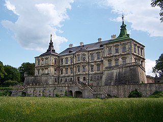
Pidhirtsi is a village of about 1,000 inhabitants in the Lviv Oblast of Ukraine, located about 80 km east of Lviv, 17 km south of Brody, 60 km north west of Ternopil, at around 49°56′39″N24°58′49″E. Known both for its castle and Basilian monastery of the Annunciation with an icon of the Mother of God.
Krzyżowa is a village in the administrative district of Gmina Ścinawa, within Lubin County, Lower Silesian Voivodeship, in south-western Poland. Prior to 1945 it was in Germany.

Pilchowice is a village in the administrative district of Gmina Wleń, within Lwówek Śląski County, Lower Silesian Voivodeship, in south-western Poland. Prior to 1945 it was in Germany. It lies approximately 5 kilometres (3 mi) south-west of Wleń, 16 km (10 mi) south of Lwówek Śląski, and 100 km (62 mi) west of the regional capital Wrocław.

Zagnańsk is a village in Kielce County, Świętokrzyskie Voivodeship, in south-central Poland. It is the seat of the gmina called Gmina Zagnańsk. It lies approximately 12 km (7 mi) north of the regional capital Kielce. The village has a population of 1,726.
Bedlenki is a village in the administrative district of Gmina Drzycim, within Świecie County, Kuyavian-Pomeranian Voivodeship, in north-central Poland. It lies approximately 8 kilometres (5 mi) south-east of Drzycim, 7 km (4 mi) north-west of Świecie, 47 km (29 mi) north-east of Bydgoszcz, and 51 km (32 mi) north of Toruń.
Dąbie is a village in the administrative district of Gmina Więcbork, within Sępólno County, Kuyavian-Pomeranian Voivodeship, in north-central Poland.
Żniatyn is a village in the administrative district of Gmina Dołhobyczów, within Hrubieszów County, Lublin Voivodeship, in eastern Poland, close to the border with Ukraine. It lies approximately 13 kilometres (8 mi) south of Dołhobyczów, 39 km (24 mi) south of Hrubieszów, and 131 km (81 mi) south-east of the regional capital Lublin.
Hańsk-Kolonia is a village in the administrative district of Gmina Hańsk, within Włodawa County, Lublin Voivodeship, in eastern Poland.

Zawada is a village in the administrative district of Gmina Tarnów, within Tarnów County, Lesser Poland Voivodeship, in southern Poland.
Zegartowice is a village in the administrative district of Gmina Imielno, within Jędrzejów County, Świętokrzyskie Voivodeship, in south-central Poland. It lies approximately 5 kilometres (3 mi) south-west of Imielno, 11 km (7 mi) south-east of Jędrzejów, and 40 km (25 mi) south-west of the regional capital Kielce.
Śniadka Pierwsza is a village in the administrative district of Gmina Bodzentyn, within Kielce County, Świętokrzyskie Voivodeship, in south-central Poland. It lies approximately 3 kilometres (2 mi) north-east of Bodzentyn and 27 km (17 mi) east of the regional capital Kielce.
Krężołek is a village in the administrative district of Gmina Łopuszno, within Kielce County, Świętokrzyskie Voivodeship, in south-central Poland. It lies approximately 4 kilometres (2 mi) north of Łopuszno and 30 km (19 mi) west of the regional capital Kielce.
Sulików is a village in the administrative district of Gmina Radków, within Włoszczowa County, Świętokrzyskie Voivodeship, in south-central Poland. It lies approximately 3 kilometres (2 mi) north of Radków, 13 km (8 mi) south of Włoszczowa, and 48 km (30 mi) west of the regional capital Kielce.
Konstantynówek is a settlement in the administrative district of Gmina Ślesin, within Konin County, Greater Poland Voivodeship, in west-central Poland.
Obelzanki is a village in the administrative district of Gmina Wronki, within Szamotuły County, Greater Poland Voivodeship, in west-central Poland. It lies approximately 5 kilometres (3 mi) north of Wronki, 20 km (12 mi) north-west of Szamotuły, and 52 km (32 mi) north-west of the regional capital Poznań.
Oskowo is a village in the administrative district of Gmina Cewice, within Lębork County, Pomeranian Voivodeship, in northern Poland. It lies approximately 6 kilometres (4 mi) south-west of Cewice, 18 km (11 mi) south of Lębork, and 61 km (38 mi) west of the regional capital Gdańsk.
Dębczyno is a village in the administrative district of Gmina Białogard, within Białogard County, West Pomeranian Voivodeship, in north-western Poland. It lies approximately 3 kilometres (2 mi) south-east of Białogard and 113 km (70 mi) north-east of the regional capital Szczecin.
Visusti is a village in Järva Parish, Järva County in northern-central Estonia.
Krychówpronounced [ˈkrɨxuv] is a village neighbourhood in the administrative district of Gmina Hańsk, within Włodawa County, Lublin Voivodeship, in eastern Poland. In 1975–98 the settlement belonged administratively to Chełm Voivodeship.


