
Wągrowiec County is a unit of territorial administration and local government (powiat) in Greater Poland Voivodeship, west-central Poland. It came into being on January 1, 1999, as a result of the Polish local government reforms passed in 1998. Its administrative seat and largest town is Wągrowiec, which lies 49 kilometres (30 mi) north-east of the regional capital Poznań. The county also contains the towns of Skoki, lying 16 km (10 mi) south of Wągrowiec, and Gołańcz, 18 km (11 mi) north-east of Wągrowiec.

Chodzież County is a unit of territorial administration and local government (powiat) in Greater Poland Voivodeship, west-central Poland. It came into being on January 1, 1999, as a result of the Polish local government reforms passed in 1998. Its administrative seat and largest town is Chodzież, which lies 65 kilometres (40 mi) north of the regional capital Poznań. The county also contains the towns of Szamocin, lying 16 km (10 mi) east of Chodzież, and Margonin, 13 km (8 mi) east of Chodzież.

Konin County is a unit of territorial administration and local government (powiat) in Greater Poland Voivodeship, west-central Poland. It came into being on January 1, 1999, as a result of the Polish local government reforms passed in 1998. Its administrative seat is the city of Konin, although the city is not part of the county. The county contains five towns: Golina, 12 km (7 mi) north-west of Konin, Kleczew, 19 km (12 mi) north of Konin, Sompolno, 27 km (17 mi) north-east of Konin, Ślesin, 17 km (11 mi) north of Konin, and Rychwał, 18 km (11 mi) south of Konin.
Krotoszyn County is a unit of territorial administration and local government (powiat) in Greater Poland Voivodeship, west-central Poland. It came into being on January 1, 1999, as a result of the Polish local government reforms passed in 1998. Its administrative seat and largest town is Krotoszyn, which lies 88 kilometres (55 mi) south-east of the regional capital Poznań. The county contains four other towns: Koźmin Wielkopolski, 16 km (10 mi) north of Krotoszyn, Zduny, 6 km (4 mi) south-west of Krotoszyn, Kobylin, 14 km (9 mi) west of Krotoszyn, and Sulmierzyce, 12 km (7 mi) south-east of Krotoszyn.

Gniezno County is a unit of territorial administration and local government (powiat) in Greater Poland Voivodeship, west-central Poland. It came into being on January 1, 1999, as a result of the Polish local government reforms passed in 1998. Its administrative seat and largest town is Gniezno, which lies 49 kilometres (30 mi) east of the regional capital Poznań. The county contains four other towns: Witkowo, 16 km (10 mi) south-east of Gniezno, Trzemeszno, 16 km (10 mi) east of Gniezno, Kłecko, 16 km (10 mi) north-west of Gniezno, and Czerniejewo, 14 km (9 mi) south-west of Gniezno.

Koło County is a unit of territorial administration and local government (powiat) in Greater Poland Voivodeship, west-central Poland. It came into being on January 1, 1999, as a result of the Polish local government reforms in 1998. Its administrative seat and largest town is Koło, which lies 119 kilometres (74 mi) east of the regional capital Poznań. The county contains three other towns: Kłodawa, 21 km (13 mi) east of Koło, Dąbie, 19 km (12 mi) south-east of Koło, and Przedecz, 21 km (13 mi) north-east of Koło.

Kościan County is a unit of territorial administration and local government (powiat) in Greater Poland Voivodeship, west-central Poland. It came into being on January 1, 1999, as a result of the Polish local government reforms passed in 1998. Its administrative seat and largest town is Kościan, which lies 40 kilometres (25 mi) south-west of the regional capital Poznań. The county contains three other towns: Śmigiel, 13 km (8 mi) south-west of Kościan, Czempiń, 13 km (8 mi) north-east of Kościan, and Krzywiń, 18 km (11 mi) south-east of Kościan.
Szamotuły County is a unit of territorial administration and local government (powiat) in Greater Poland Voivodeship, west-central Poland. It came into existence on January 1, 1999, as a result of the Polish local government reforms passed in 1998. Its administrative seat and largest town is Szamotuły, which lies 32 kilometres (20 mi) north-west of the regional capital Poznań. The county contains four other towns: Wronki, 18 km (11 mi) north-west of Szamotuły, Pniewy, 24 km (15 mi) south-west of Szamotuły, Obrzycko, 13 km (8 mi) north of Szamotuły, and Ostroróg, 9 km (6 mi) north-west of Szamotuły.

Śrem County is a unit of territorial administration and local government (powiat) in Greater Poland Voivodeship, west-central Poland. It came into being on January 1, 1999, as a result of the Polish local government reforms passed in 1998. Its administrative seat and largest town is Śrem, which lies 36 kilometres (22 mi) south of the regional capital Poznań. The county also contains the towns of Książ Wielkopolski, lying 15 km (9 mi) east of Śrem, and Dolsk, 12 km (7 mi) south of Śrem.

Słupca County is a unit of territorial administration and local government (powiat) in Greater Poland Voivodeship, west-central Poland. It came into being on January 1, 1999, as a result of the Polish local government reforms passed in 1998. Its administrative seat and largest town is Słupca, which lies 66 kilometres (41 mi) east of the regional capital Poznań. The only other town in the county is Zagórów, lying 16 km (10 mi) south of Słupca.

Kalisz County is a unit of territorial administration and local government (powiat) in Greater Poland Voivodeship, west-central Poland. It came into being on 1 January 1999 as a result of the Polish local government reforms passed in 1998. Its administrative seat is the city of Kalisz, although the city is not part of the county. The only town in Kalisz County is Stawiszyn, which lies 18 km (11 mi) north of Kalisz.

Kutno County is a unit of territorial administration and local government (powiat) in Łódź Voivodeship, central Poland. It came into being on 1 January 1999 as a result of the Polish local government reforms passed in 1998. Its administrative seat and largest town is Kutno, which lies 51 kilometres (32 mi) north of the regional capital Łódź. The county also contains the towns of Żychlin, lying 18 km (11 mi) east of Kutno, and Krośniewice, 14 km (9 mi) west of Kutno.
Sieradz County is a unit of territorial administration and local government (powiat) in Łódź Voivodeship, central Poland. It came into being on January 1, 1999, as a result of the Polish local government reforms passed in 1998. Its administrative seat and largest town is Sieradz, which lies 54 kilometres (34 mi) west of the regional capital Łódź. The county contains three other towns: Złoczew, lying 23 km (14 mi) south-west of Sieradz, Warta, lying 14 km (9 mi) north-west of Sieradz, and Błaszki, 23 km (14 mi) west of Sieradz.

Poddębice County is a unit of territorial administration and local government (powiat) in Łódź Voivodeship, central Poland. It came into being on January 1, 1999, as a result of the Polish local government reforms passed in 1998. Its administrative seat and largest town is Poddębice, which lies 37 kilometres (23 mi) west of the regional capital Łódź. The only other town in the county is Uniejów, lying 14 km (9 mi) north-west of Poddębice.
Iława County is a unit of territorial administration and local government (powiat) in Warmian-Masurian Voivodeship, northern Poland.

Łobez County is a unit of territorial administration and local government (powiat) in West Pomeranian Voivodeship, north-western Poland. Its administrative seat and largest town is Łobez, which lies 73 kilometres (45 mi) east of the regional capital Szczecin. The county contains three other towns: Resko, 24 km (15 mi) north-west of Łobez, Węgorzyno, 12 km (7 mi) south of Łobez, and Dobra, 22 km (14 mi) west of Łobez.

Białogard County is a unit of territorial administration and local government (powiat) in West Pomeranian Voivodeship, north-western Poland. It came into being on January 1, 1999, as a result of the Polish local government reforms passed in 1998. Its administrative seat and largest town is Białogard, which lies 113 kilometres (70 mi) north-east of the regional capital Szczecin. The only other towns in the county are Karlino, lying 9 km (6 mi) north-west of Białogard, and Tychowo, 20 km (12 mi) south-east of Białogard.

Nowy Targ County is a unit of territorial administration and local government (powiat) in Lesser Poland Voivodeship, southern Poland, on the Slovak border. It came into being on January 1, 1999, as a result of the Polish local government reforms passed in 1998. Its administrative seat and largest town is Nowy Targ, which lies 67 kilometres (42 mi) south of the regional capital Kraków. The county also contains the towns of Rabka-Zdrój, lying 18 km (11 mi) north of Nowy Targ, and Szczawnica, 35 km (22 mi) east of Nowy Targ.

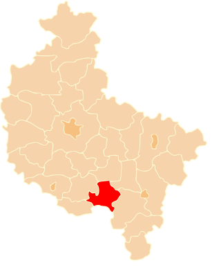
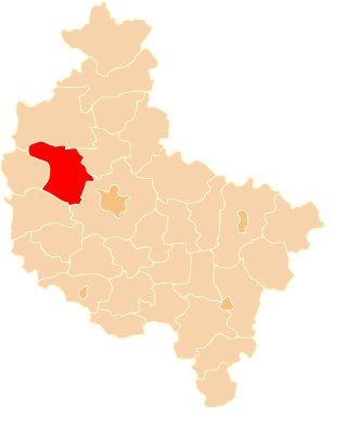
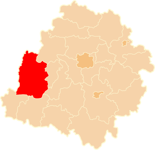
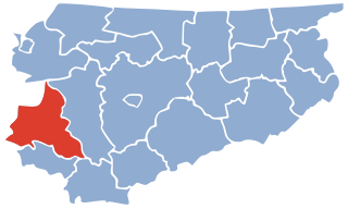
Gmina Dobra is an urban-rural gmina in Turek County, Greater Poland Voivodeship, in west-central Poland. Its seat is the town of Dobra, which lies approximately 15 kilometres (9 mi) south-east of Turek and 128 km (80 mi) south-east of the regional capital Poznań.

Gmina Tuliszków is an urban-rural gmina in Turek County, Greater Poland Voivodeship, in west-central Poland. Its seat is the town of Tuliszków, which lies approximately 16 kilometres (10 mi) north-west of Turek and 101 km (63 mi) east of the regional capital Poznań.


