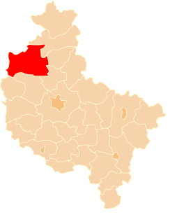
Czarnków-Trzcianka County is a unit of territorial administration and local government (powiat) in Greater Poland Voivodeship, west-central Poland. It came into being on January 1, 1999, as a result of the Polish local government reforms passed in 1998. Its administrative seat is the town of Czarnków, which lies 61 kilometres (38 mi) north-west of the regional capital Poznań. The county contains three other towns: Trzcianka, 18 km (11 mi) north of Czarnków, Krzyż Wielkopolski, 38 km (24 mi) west of Czarnków, and Wieleń, 27 km (17 mi) west of Czarnków.

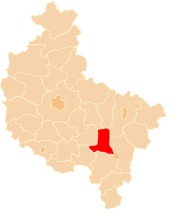
Poznań County is a unit of territorial administration and local government (powiat) in Greater Poland Voivodeship, west-central Poland. It came into being on January 1, 1999, as a result of the Polish local government reforms passed in 1998. Its administrative seat is the city of Poznań, although the city is not part of the county. The county's administrative offices are in the Jeżyce neighbourhood of Poznań.
Wągrowiec County is a unit of territorial administration and local government (powiat) in Greater Poland Voivodeship, west-central Poland. It came into being on January 1, 1999, as a result of the Polish local government reforms passed in 1998. Its administrative seat and largest town is Wągrowiec, which lies 49 kilometres (30 mi) north-east of the regional capital Poznań. The county also contains the towns of Skoki, lying 16 km (10 mi) south of Wągrowiec, and Gołańcz, 18 km (11 mi) north-east of Wągrowiec.

Chodzież County is a unit of territorial administration and local government (powiat) in Greater Poland Voivodeship, west-central Poland. It came into being on January 1, 1999, as a result of the Polish local government reforms passed in 1998. Its administrative seat and largest town is Chodzież, which lies 65 kilometres (40 mi) north of the regional capital Poznań. The county also contains the towns of Szamocin, lying 16 km (10 mi) east of Chodzież, and Margonin, 13 km (8 mi) east of Chodzież.

Jarocin County is a unit of territorial administration and local government (powiat) in Greater Poland Voivodeship, west-central Poland. It came into being on January 1, 1999, as a result of the Polish local government reforms passed in 1998. Its administrative seat and largest town is Jarocin, which lies 63 kilometres (39 mi) south-east of the regional capital Poznań. The only other town in the county is Żerków, lying 12 km (7 mi) north of Jarocin.

Turek County is a unit of territorial administration and local government (powiat) in Greater Poland Voivodeship, west-central Poland. It came into being on January 1, 1999, as a result of the Polish local government reforms passed in 1998. Its administrative seat and largest town is Turek, which lies 117 kilometres (73 mi) east of the regional capital Poznań. The county also contains the towns of Tuliszków, lying 16 km (10 mi) north-west of Turek, and Dobra, 15 km (9 mi) south-east of Turek.
Gniezno County is a unit of territorial administration and local government (powiat) in Greater Poland Voivodeship, west-central Poland. It came into being on January 1, 1999, as a result of the Polish local government reforms passed in 1998. Its administrative seat and largest town is Gniezno, which lies 49 kilometres (30 mi) east of the regional capital Poznań. The county contains four other towns: Witkowo, 16 km (10 mi) south-east of Gniezno, Trzemeszno, 16 km (10 mi) east of Gniezno, Kłecko, 16 km (10 mi) north-west of Gniezno, and Czerniejewo, 14 km (9 mi) south-west of Gniezno.
Gostyń County is a unit of territorial administration and local government (powiat) in Greater Poland Voivodeship, west-central Poland. It came into being on January 1, 1999, as a result of the Polish local government reforms passed in 1998. Its administrative seat and largest town is Gostyń, which lies 59 kilometres (37 mi) south of the regional capital Poznań. The county contains four other towns: Krobia, 11 km (7 mi) south of Gostyń, Poniec, 20 km (12 mi) south-west of Gostyń, Borek Wielkopolski, 17 km (11 mi) east of Gostyń, and Pogorzela, 17 km (11 mi) south-east of Gostyń.

Kępno County is a unit of territorial administration and local government (powiat) in Greater Poland Voivodeship, west-central Poland. It came into being on January 1, 1999, as a result of the Polish local government reforms passed in 1998. Its administrative seat and only town is Kępno, which lies 144 kilometres (89 mi) south-east of the regional capital Poznań.
Pleszew County is a unit of territorial administration and local government (powiat) in Greater Poland Voivodeship, west-central Poland. It came into being on January 1, 1999, as a result of the Polish local government reforms passed in 1998. Its administrative seat is the town of Pleszew, which lies 83 kilometres (52 mi) south-east of the regional capital Poznań.

Środa Wielkopolska County is a unit of territorial administration and local government (powiat) in Greater Poland Voivodeship, west-central Poland. It came into being on January 1, 1999, as a result of the Polish local government reforms passed in 1998. Its administrative seat and only town is Środa Wielkopolska, which lies 32 kilometres (20 mi) south-east of the regional capital Poznań.

Kościan County is a unit of territorial administration and local government (powiat) in Greater Poland Voivodeship, west-central Poland. It came into being on January 1, 1999, as a result of the Polish local government reforms passed in 1998. Its administrative seat and largest town is Kościan, which lies 40 kilometres (25 mi) south-west of the regional capital Poznań. The county contains three other towns: Śmigiel, 13 km (8 mi) south-west of Kościan, Czempiń, 13 km (8 mi) north-east of Kościan, and Krzywiń, 18 km (11 mi) south-east of Kościan.

Szamotuły County is a unit of territorial administration and local government (powiat) in Greater Poland Voivodeship, west-central Poland. It came into existence on January 1, 1999, as a result of the Polish local government reforms passed in 1998. Its administrative seat and largest town is Szamotuły, which lies 32 kilometres (20 mi) north-west of the regional capital Poznań. The county contains four other towns: Wronki, 18 km (11 mi) north-west of Szamotuły, Pniewy, 24 km (15 mi) south-west of Szamotuły, Obrzycko, 13 km (8 mi) north of Szamotuły, and Ostroróg, 9 km (6 mi) north-west of Szamotuły.

Międzychód County is a unit of territorial administration and local government (powiat) in Greater Poland Voivodeship, west-central Poland. It came into being on January 1, 1999, as a result of the Polish local government reforms passed in 1998. Its administrative seat and largest town is Międzychód, which lies 74 kilometres (46 mi) west of the regional capital Poznań. The only other town in the county is Sieraków, lying 16 km (10 mi) east of Międzychód.

Śrem County is a unit of territorial administration and local government (powiat) in Greater Poland Voivodeship, west-central Poland. It came into being on January 1, 1999, as a result of the Polish local government reforms passed in 1998. Its administrative seat and largest town is Śrem, which lies 36 kilometres (22 mi) south of the regional capital Poznań. The county also contains the towns of Książ Wielkopolski, lying 15 km (9 mi) east of Śrem, and Dolsk, 12 km (7 mi) south of Śrem.
Słupca County is a unit of territorial administration and local government (powiat) in Greater Poland Voivodeship, west-central Poland. It came into being on January 1, 1999, as a result of the Polish local government reforms passed in 1998. Its administrative seat and largest town is Słupca, which lies 66 kilometres (41 mi) east of the regional capital Poznań. The only other town in the county is Zagórów, lying 16 km (10 mi) south of Słupca.
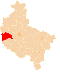
Nowy Tomyśl County is a unit of territorial administration and local government (powiat) in Greater Poland Voivodeship, west-central Poland. It came into being on January 1, 1999, as a result of the Polish local government reforms passed in 1998. Its administrative seat and largest town is Nowy Tomyśl, which lies 55 kilometres (34 mi) west of the regional capital Poznań. The county contains three other towns: Opalenica, 20 km (12 mi) east of Nowy Tomyśl, Zbąszyń, 17 km (11 mi) south-west of Nowy Tomyśl, and Lwówek, 16 km (10 mi) north of Nowy Tomyśl.
Gmina Murowana Goślina is an urban-rural gmina in Poznań County, Greater Poland Voivodeship, in west-central Poland. Its seat is the town of Murowana Goślina, which lies approximately 20 kilometres (12 mi) north of the regional capital Poznań. The gmina consists of Murowana Goślina and the countryside and villages mainly to the north and east of that town. Much of the eastern part of the gmina is covered by the forests of the Puszcza Zielonka Landscape Park.
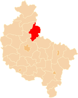
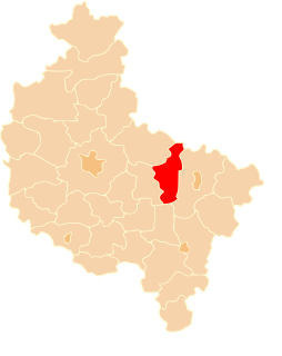
Gmina Rogoźno is an urban-rural gmina in Oborniki County, Greater Poland Voivodeship, in west-central Poland. Its seat is the town of Rogoźno, which lies approximately 17 kilometres (11 mi) north-east of Oborniki and 40 km (25 mi) north of the regional capital Poznań.
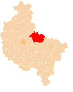
Gmina Oborniki is an urban-rural gmina in Oborniki County, Greater Poland Voivodeship, in west-central Poland. Its seat is the town of Oborniki, which lies approximately 29 kilometres (18 mi) north of the regional capital Poznań.


