
Poznań County is a unit of territorial administration and local government (powiat) in Greater Poland Voivodeship, west-central Poland. It came into being on January 1, 1999, as a result of the Polish local government reforms passed in 1998. Its administrative seat is the city of Poznań, although the city is not part of the county. The county's administrative offices are in the Jeżyce neighbourhood of Poznań.

Wągrowiec County is a unit of territorial administration and local government (powiat) in Greater Poland Voivodeship, west-central Poland. It came into being on January 1, 1999, as a result of the Polish local government reforms passed in 1998. Its administrative seat and largest town is Wągrowiec, which lies 49 kilometres (30 mi) north-east of the regional capital Poznań. The county also contains the towns of Skoki, lying 16 km (10 mi) south of Wągrowiec, and Gołańcz, 18 km (11 mi) north-east of Wągrowiec.
Choszczno County is a unit of territorial administration and local government (powiat) in West Pomeranian Voivodeship, north-western Poland. It came into being on January 1, 1999, as a result of the Polish local government reforms passed in 1998. Its administrative seat and largest town is Choszczno, which lies 62 kilometres (39 mi) south-east of the regional capital Szczecin. The county contains three other towns: Recz, 15 km (9 mi) north-east of Choszczno, Pełczyce, 16 km (10 mi) south-west of Choszczno, and Drawno, 24 km (15 mi) east of Choszczno.
Ostrów County is a unit of territorial administration and local government (powiat) in Greater Poland Voivodeship, west-central Poland. It came into being on January 1, 1999, as a result of the Polish local government reforms passed in 1998. Its administrative seat and largest town is Ostrów Wielkopolski, which lies 100 kilometres (62 mi) south-east of the regional capital Poznań. The county contains three other towns: Nowe Skalmierzyce, 22 km (14 mi) east of Ostrów Wielkopolski, Odolanów, 10 km (6 mi) south of Ostrów Wielkopolski, and Raszków, 8 km (5 mi) north of Ostrów Wielkopolski.

Konin County is a unit of territorial administration and local government (powiat) in Greater Poland Voivodeship, west-central Poland. It came into being on January 1, 1999, as a result of the Polish local government reforms passed in 1998. Its administrative seat is the city of Konin, although the city is not part of the county. The county contains five towns: Golina, 12 km (7 mi) north-west of Konin, Kleczew, 19 km (12 mi) north of Konin, Sompolno, 27 km (17 mi) north-east of Konin, Ślesin, 17 km (11 mi) north of Konin, and Rychwał, 18 km (11 mi) south of Konin.

Turek County is a unit of territorial administration and local government (powiat) in Greater Poland Voivodeship, west-central Poland. It came into being on 1 January 1999 as a result of the Polish local government reforms passed in 1998. Its administrative seat and largest town is Turek, which lies 117 kilometres (73 mi) east of the regional capital Poznań. The county also contains the towns of Tuliszków, lying 16 km (10 mi) north-west of Turek, and Dobra, 15 km (9 mi) south-east of Turek.

Ostrzeszów County is a unit of territorial administration and local government (powiat) in Greater Poland Voivodeship, west-central Poland. It came into being on January 1, 1999, as a result of the Polish local government reforms passed in 1998. Its administrative seat and largest town is Ostrzeszów, which lies 134 kilometres (83 mi) south-east of the regional capital Poznań. The county also contains the towns of Grabów nad Prosną, lying 14 km (9 mi) north-east of Ostrzeszów, and Mikstat, 15 km (9 mi) north of Ostrzeszów.

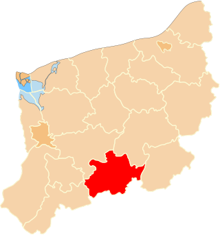
Pleszew County is a unit of territorial administration and local government (powiat) in Greater Poland Voivodeship, west-central Poland. It came into being on January 1, 1999, as a result of the Polish local government reforms passed in 1998. Its administrative seat is the town of Pleszew, which lies 83 kilometres (52 mi) south-east of the regional capital Poznań.

Koło County is a unit of territorial administration and local government (powiat) in Greater Poland Voivodeship, west-central Poland. It came into being on January 1, 1999, as a result of the Polish local government reforms in 1998. Its administrative seat and largest town is Koło, which lies 119 kilometres (74 mi) east of the regional capital Poznań. The county contains three other towns: Kłodawa, 21 km (13 mi) east of Koło, Dąbie, 19 km (12 mi) south-east of Koło, and Przedecz, 21 km (13 mi) north-east of Koło.
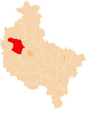
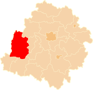
Szamotuły County is a unit of territorial administration and local government (powiat) in Greater Poland Voivodeship, west-central Poland. It came into existence on January 1, 1999, as a result of the Polish local government reforms passed in 1998. Its administrative seat and largest town is Szamotuły, which lies 32 kilometres (20 mi) north-west of the regional capital Poznań. The county contains four other towns: Wronki, 18 km (11 mi) north-west of Szamotuły, Pniewy, 24 km (15 mi) south-west of Szamotuły, Obrzycko, 13 km (8 mi) north of Szamotuły, and Ostroróg, 9 km (6 mi) north-west of Szamotuły.
Oświęcim County is a unit of territorial administration and local government (powiat) in Lesser Poland Voivodeship, southern Poland. It came into being on January 1, 1999, as a result of the Polish local government reforms passed in 1998. Its administrative seat and largest town is Oświęcim, which lies 51 kilometres (32 mi) west of the regional capital Kraków. The county contains four other towns: Kęty, 17 km (11 mi) south of Oświęcim, Brzeszcze, 9 km (6 mi) south-west of Oświęcim, Chełmek, 8 km (5 mi) north of Oświęcim, and Zator, 16 km (10 mi) east of Oświęcim.
Sieradz County is a unit of territorial administration and local government (powiat) in Łódź Voivodeship, central Poland. It came into being on January 1, 1999, as a result of the Polish local government reforms passed in 1998. Its administrative seat and largest town is Sieradz, which lies 54 kilometres (34 mi) west of the regional capital Łódź. The county contains three other towns: Złoczew, lying 23 km (14 mi) south-west of Sieradz, Warta, lying 14 km (9 mi) north-west of Sieradz, and Błaszki, 23 km (14 mi) west of Sieradz.

Piotrków County is a unit of territorial administration and local government (powiat) in Łódź Voivodeship, central Poland. It came into being on January 1, 1999, as a result of the Polish local government reforms passed in 1998. Its administrative seat is the city of Piotrków Trybunalski, although the city is not part of the county. The only towns in Piotrków County are Sulejów, which lies 15 km (9 mi) east of Piotrków Trybunalski, and Wolbórz.

Goleniów County is a unit of territorial administration and local government (powiat) in West Pomeranian Voivodeship, north-western Poland. It came into being on January 1, 1999, as a result of the Polish local government reforms passed in 1998. Its administrative seat and largest town is Goleniów, which lies 22 kilometres (14 mi) north-east of the regional capital Szczecin. The county also contains the towns of Nowogard, lying 24 km (15 mi) north-east of Goleniów, and Maszewo, 19 km (12 mi) south-east of Goleniów.

Koszalin County is a unit of territorial administration and local government (powiat) in West Pomeranian Voivodeship, north-western Poland, on the Baltic coast. It came into being on January 1, 1999, as a result of the Polish local government reforms passed in 1998. Its administrative seat is the city of Koszalin, although the city is not part of the county. The county contains three towns: Sianów, 10 km (6 mi) north-east of Koszalin, Bobolice, 37 km (23 mi) south-east of Koszalin, and Polanów, 35 km (22 mi) east of Koszalin.

Drawsko County is a unit of territorial administration and local government (powiat) in West Pomeranian Voivodeship, north-western Poland. It came into being on January 1, 1999, as a result of the Polish local government reforms passed in 1998. Its administrative seat is the town of Drawsko Pomorskie, which lies 82 kilometres (51 mi) east of the regional capital Szczecin. The county contains three other towns: Złocieniec, 15 km (9 mi) east of Drawsko Pomorskie, Czaplinek, 29 km (18 mi) east of Drawsko Pomorskie, and Kalisz Pomorski, 29 km (18 mi) south of Drawsko Pomorskie.
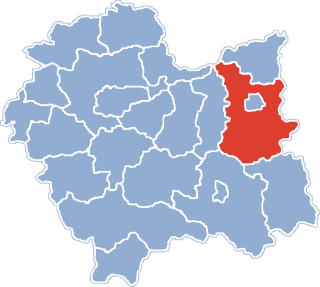
Tarnów County is a unit of territorial administration and local government (powiat) in Lesser Poland Voivodeship, southern Poland. It came into being on January 1, 1999, as a result of the Polish local government reforms passed in 1998. Its administrative seat is the city of Tarnów, although the city is not part of the county. The county contains seven towns: Tuchów, 16 km (10 mi) south of Tarnów, Żabno, 14 km (9 mi) north-west of Tarnów, Wojnicz, 15 km (9 mi) south-west of Tarnów, Radłów, 13 km (8 mi) north-west of Tarnów, Ryglice, 20 km (12 mi) south-east of Tarnów, Ciężkowice, 26 km (16 mi) south of Tarnów, and Zakliczyn, 25 km (16 mi) south-west of Tarnów.

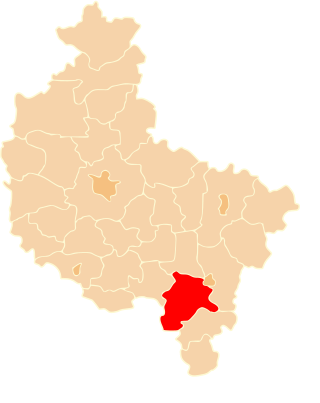
Gmina Blizanów is a rural gmina in Kalisz County, Greater Poland Voivodeship, in west-central Poland. Its seat is the village of Blizanów, which lies approximately 17 kilometres (11 mi) north of Kalisz and 94 km (58 mi) south-east of the regional capital Poznań.
Gmina Stawiszyn is an urban-rural gmina in Kalisz County, Greater Poland Voivodeship, in west-central Poland. Its seat is the town of Stawiszyn, which lies approximately 18 kilometres (11 mi) north of Kalisz and 98 km (61 mi) south-east of the regional capital Poznań.
Gmina Żelazków is a rural gmina in Kalisz County, Greater Poland Voivodeship, in west-central Poland. Its seat is the village of Żelazków, which lies approximately 12 kilometres (7 mi) north-east of Kalisz and 105 km (65 mi) south-east of the regional capital Poznań.


