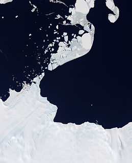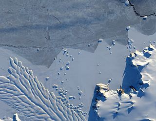
Lillie Glacier is a large glacier in Antarctica, about 100 nautical miles (190 km) long and 10 nautical miles (19 km) wide. It lies between the Bowers Mountains on the west and the Concord Mountains and Anare Mountains on the east, flowing to Ob' Bay on the coast and forming the Lillie Glacier Tongue.
Koettlitz Glacier is a large Antarctic glacier lying west of Mount Morning and Mount Discovery in the Royal Society Range, flowing from the vicinity of Mount Cocks northeastward between Brown Peninsula and the mainland into the ice shelf of McMurdo Sound.

Fisher Glacier is a prominent western tributary to the Lambert Glacier, about 100 nautical miles long, flowing east past the north sides of Mount Menzies and Mount Rubin and joining the main stream of the Lambert Glacier just east of Mount Stinear. It was sighted from Australian National Antarctic Research Expeditions aircraft by K.B. Mather in 1957, and was named by the Antarctic Names Committee of Australia for N.H. Fisher, chief geologist at the Bureau of Mineral Resources, Department of National Development, Australia.

Aagaard Glacier, also known as Glaciar Alderete, is an 8-mile (13 km) long Antarctic glacier which lies close to the east of Gould Glacier and flows in a southerly direction into Mill Inlet, on the east coast of Graham Land. It was charted by the Falkland Islands Dependencies Survey (FIDS) and photographed from the air by the Ronne Antarctic Research Expedition during December 1947; it was named by the FIDS for Bjarne Aagaard, a Norwegian authority on Antarctic whaling and exploration.

Astrolabe Glacier is a glacier 7 kilometres (4 nmi) wide and 19 kilometres (10 nmi) long, flowing north-northeast from the continental ice and terminating at the coast in a prominent tongue at the east side of Geologie Archipelago. It was first sighted in 1840 by the French expedition under Captain Jules Dumont d'Urville, although no glaciers were noted on d'Urville's chart of this coast but a formidable icy dike with perpendicular flanks of 37.7 m high according to the joined plate, corresponding to the glacier tongue. The glacier was photographed from the air by U.S. Navy Operation Highjump in January 1947. It was charted by the French Antarctic Expedition, 1949–51, and named after d'Urville's flagship, the Astrolabe.

Mariner Glacier is a major glacier over 100 km (62 mi) long, descending southeast from the plateau of Victoria Land, between Mountaineer Range and Malta Plateau, and terminating at Lady Newnes Bay, Ross Sea, where it forms the floating Mariner Glacier Tongue. Its lower reaches and entrance to its valley were reconnoitered in December 1958 by Captain John Cadwalader, US Navy, and two members of New Zealand Geological Survey Antarctic Expedition (NZGSAE), in a flight from the icebreakers USS Glacier and USS Staten Island which were lying close off the south end of Coulman Island, in an attempt to land expedition members on the mainland. Named by NZGSAE, 1958–59, as a tribute to the work of mariners in Antarctic research and exploration.

Zélée Glacier is a glacier about 6 kilometres (3 nmi) wide and 11 kilometres (6 nmi) long, flowing north-northwest from the continental ice along the west side of Lacroix Nunatak and terminating in a prominent tongue at the west side of Port Martin. Probably first sighted in 1840 by the French expedition under Captain Jules Dumont d'Urville, although no glaciers were noted on d'Urville's chart of this coast. Photographed from the air by U.S. Navy Operation Highjump, 1946-47. Charted by the French Antarctic Expedition under Liotard, 1949–51, and named for the Zélée, corvette which accompanied d'Urville's flagship, the Astrolabe.

Dibble Glacier in Antarctica is a prominent channel glacier flowing from the continental ice and terminating in a prominent tongue at the east side of Davis Bay. It was delineated from air photos taken by U.S. Navy Operation Highjump (1946–47), and named by the Advisory Committee on Antarctic Names for Jonas Dibble, ship's carpenter on the sloop Peacock of the United States Exploring Expedition (1838–42) under Charles Wilkes. Dibble is credited with leaving his sick bed and working 24 hours without relief with other carpenters to repair a broken rudder on the Peacock, when the ship was partially crushed in an ice bay in 151°19′E and forced to retire northward.

Anuchin Glacier is a glacier draining southward to Lake Unter-See in the northern part of the Gruber Mountains, Queen Maud Land. It was discovered, and plotted from air photos, by the Third German Antarctic Expedition, 1938–39. It was mapped from air photos and from surveys by the Sixth Norwegian Antarctic Expedition, 1956–60, and remapped by the Soviet Antarctic Expedition, 1960–61, and named after Dmitry Nikolayevich Anuchin, Soviet geographer.
Bon Docteur Nunatak, also known as Good Doctor Nunatak, is a small coastal nunatak, 28 metres (92 ft) high, standing at the west side of the Astrolabe Glacier Tongue, 400 m (1,300 ft) south of Rostand Island in the Geologie Archipelago of Antarctica. It was photographed from the air by U.S. Navy Operation Highjump, 1946–47, charted by the French Antarctic Expedition, 1952–53, and named for Dr Jean Cendron, the "good doctor", medical officer and biologist with the French Antarctic Expedition, 1951–52.

Commandant Charcot Glacier is a prominent glacier about 3 nautical miles (6 km) wide and 12 nautical miles (22 km) long, flowing north-northwest from the continental ice to its terminus at the head of Victor Bay. It was delineated from aerial photographs taken by U.S. Navy Operation Highjump, 1946–47. The French Antarctic Expedition, 1950–1952, under Mario Marret sledged west along the coast to Victor Bay, close east of this glacier, in December 1952, and it was named by them for the polar ship Commandant Charcot which transported French expeditions to this area, 1948–1952.
Commandant Charcot Glacier Tongue is a broad glacier tongue about 2 nautical miles (4 km) long extending seaward from Commandant Charcot Glacier. It was charted by the French Antarctic Expedition, 1950–52, and named by them for the French polar ship Commandant Charcot.

Waldron Glacier is a channel glacier flowing to the east side of Porpoise Bay, midway between Sandford and Morse Glaciers. Delineated from air photos taken by U.S. Navy Operation Highjump (1946–47). Named by Advisory Committee on Antarctic Names (US-ACAN) for Thomas W. Waldron, captain's clerk on the brig Porpoise of the United States Exploring Expedition (1838–42) under Wilkes.

Pourquoi Pas Glacier is a glacier 4 nautical miles (7 km) wide and 15 nautical miles (28 km) long, flowing north-northwest from the continental ice and terminating in a prominent tongue 9 nautical miles (17 km) west-northwest of Pourquoi Pas Point. Delineated by French cartographers from air photos taken by U.S. Navy Operation Highjump, 1946–47. Named in 1952 by the French Antarctic Sub-committee after the Pourquoi-Pas?, polar ship of the French Antarctic Expedition under Charcot, 1908–10, later used by Charcot in expeditions to Greenland.

Matusevich Glacier is a broad glacier about 50 nautical miles (90 km) long, with a well developed glacier tongue, flowing to the coast of East Antarctica between the Lazarev Mountains and the northwestern extremity of the Wilson Hills.

Liotard Glacier is a channel glacier in Antarctica. It is about 3 nautical miles (6 km) wide and 6 nautical miles (11 km) long, and flows north-northeast from the continental ice, terminating in a small ice tongue about 4 nautical miles (7 km) west of Hélène Island. The glacier was delineated from air photos taken by U.S. Navy Operation Highjump, 1946–47, and was named by the Advisory Committee on Antarctic Names for Andre-Frank Liotard, the leader of the French Antarctic Expedition, 1949–51, whose group completed the initial survey of the coastal features as far westward as this glacier.
Melba Peninsula is a broad, ice-covered peninsula between Reid Glacier and the Bay of Winds, fronting on Shackleton Ice Shelf, Antarctica. It was discovered by the Australasian Antarctic Expedition under Mawson, 1911–14, who named it for Dame Nellie Melba of Melbourne, a patron of the expedition.

Sørsdal Glacier is a heavily crevassed glacier on the Ingrid Christensen Coast of Princess Elizabeth Land in Antarctica, 15 nautical miles (28 km) long, flowing westward along the south side of Krok Fjord and the Vestfold Hills and terminating in a prominent glacier tongue at Prydz Bay. Discovered in February 1935 by a Norwegian expedition under Captain Klarius Mikkelsen and named for Lief Sørsdal, a Norwegian dentist and a member of the party from the whaling ship Thorshavn that landed at the northern end of the Vestfold Hills.

Hovde Glacier is a small glacier just west of the Brattstrand Bluffs, and east of Amanda Bay, on the south-eastern shore of Prydz Bay, Antarctica. A short tongue from this glacier extends seaward to nearby Hovde Island. The glacier was first mapped by the Lars Christensen Expedition, 1936–37, which named the island. It was named "Hovde Ice Tongue" by John H. Roscoe in 1952 following his study of aerial photographs of the area taken by U.S. Navy Operation Highjump, 1946–47, but the term glacier is considered appropriate to this small feature.


