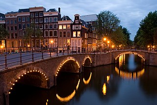
Amsterdam is the capital and most populous city of the Netherlands; with a population of 907,976 within the city proper, 1,558,755 in the urban area and 2,480,394 in the metropolitan area. Found within the Dutch province of North Holland, Amsterdam is colloquially referred to as the "Venice of the North", due to the large number of canals which form a UNESCO World Heritage Site.

The Rijksmuseum is the national museum of the Netherlands dedicated to Dutch arts and history and is located in Amsterdam. The museum is located at the Museum Square in the borough Amsterdam South, close to the Van Gogh Museum, the Stedelijk Museum Amsterdam, and the Concertgebouw.
Lyngby-Taarbæk Municipality is a municipality in the Capital Region of Denmark near Copenhagen on the eastern coast of the island of Zealand. It is part of the Greater Copenhagen area. The municipality borders Rudersdal Municipality to the north, Furesø Municipality to the west and Gladsaxe and Gentofte Municipality to the south. It borders the Øresund to the east.

The Jordaan is a neighbourhood of the city of Amsterdam, Netherlands. It is part of the borough of Amsterdam-Centrum. The area is bordered by the Singelgracht canal and the neighbourhood of Frederik Hendrikbuurt to the west; the Prinsengracht to the east; the Brouwersgracht to the north and the Leidsegracht to the south. The former canal Rozengracht is the main traffic artery through the neighbourhood.

Oud-Zuid is the name of a neighbourhood and of a (larger) former borough (stadsdeel) of Amsterdam.

Oud-West is a neighborhood of Amsterdam, Netherlands, roughly covering the area between the Overtoom, a major thoroughfare west of the city centre, and the parallel De Clercqstraat, a shopping street. The exact boundaries are the Vondelpark and the Singelgracht, Hugo de Grootgracht and Kostverlorenvaart canals. The neighbourhood consists of two historically and demographically distinct communities: the Overtoombuurt in the south and the Kinkerbuurt in the north.

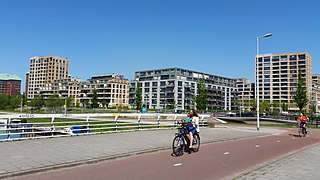
IJburg is a residential neighbourhood under construction in Amsterdam, Netherlands. It is situated in the IJmeer and is being built on artificial islands which have been raised from the lake. The Haveneiland, Rieteilanden, Steigereiland and Centrumeiland are already inhabited as of 2004. It is part of the municipality Amsterdam-Oost and also contains the Diemerpark, one of the city's largest parks.

The Oosterpark is the first large park laid out by the municipality of Amsterdam. Located near the Singelgracht to the north, it is the principal component of the Oosterpark neighbourhood in the Oost borough. The park, an English garden, was designed by Dutch landscape architect Leonard Anthony Springer and completed in 1891.
Kolenkit District is a neighbourhood in Amsterdam, Netherlands.

Amsterdam-West is a borough of Amsterdam, Netherlands, to the west of the centre of the city. This borough was formed in 2010 through the merging of four former boroughs Oud West, Westerpark, De Baarsjes and Bos en Lommer.
Amsterdam Nieuw-West is a borough comprising the westernmost neighbourhoods of the city of Amsterdam, Netherlands. It was created in 2010 after a merger of the former boroughs Osdorp, Geuzenveld-Slotermeer and Slotervaart. In 2017, the borough had almost 150,000 inhabitants.

Frederik Hendrikbuurt is a neighbourhood in the West district of Amsterdam, Netherlands and is situated between the canals Singelgracht and Kostverlorenvaart. The neighbourhood, known locally by the moniker the "Fred", is centred on the Frederik Hendrikplantsoen park and was planned during the last quarter of the nineteenth century as a confluence of green space and housing meant to be stand apart from the overcrowded Jordaan district. The construction of the neighbourhood was mostly complete by the start of the Second World War (1940).

Houthaven is a neighbourhood of Amsterdam, Netherlands situated in the West borough. Literally meaning "lumber port", Houthaven is a port situated along the IJ in Amsterdam's western port. It is bordered by a dam in the IJ river to the north and the Spaarndammerbuurt in the south. It is currently predominantly used by inland barges, however plans are in motion to radically change the area in the next few years by building a new residential area on seven artificial islands.
Java-eiland is a neighbourhood of Amsterdam, Netherlands. It is located on a peninsula, surrounded on three sides by water and on the east by the KNSM Island neighbourhood.
The Jodenbuurt is a neighbourhood of Amsterdam, Netherlands. For centuries before World War II, it was the center of the Dutch Jews of Amsterdam — hence, its name. It is best known as the birthplace of Baruch Spinoza, the home of Rembrandt, and the Jewish ghetto of Nazi occupation of the Netherlands.

The Oosterparkbuurt is a neighbourhood of Amsterdam, Netherlands. The neighbourhood derives its name from the Oosterpark. Three of its main streets were also named after the park. The neighbourhood was built late in the 19th century. Until World War II, it was home to many working-class Jews. During urban renewal operations of the 1970s and 1980s, many of the original 19th-century housing was demolished and replaced.

Rivierenbuurt is a neighbourhood of Amsterdam, Netherlands. The neighbourhood is situated in the eastern part of the borough of Amsterdam-Zuid, bordered by the river Amstel to the east, the Boerenwetering canal in the west, the Amstelkanaal in the north and the A10 motorway in the south. In 2013, the Rivierenbuurt had approximately 28,400 residents.
The following is a timeline of the history of the municipality of Amsterdam, Netherlands.

Tamborine is a town in the Scenic Rim Region and a locality split between the Scenic Rim Region and the City of Logan in Queensland, Australia. In the 2016 census the locality of Tamborine had a population of 3,950 people.

