

Map showing the location of Friday Island within Berkshire.
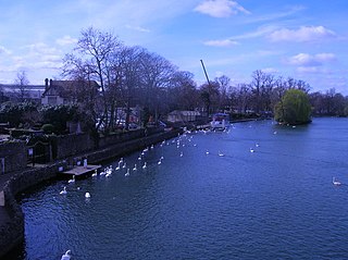
Friday Island is an island in the River Thames in England at Old Windsor, Berkshire. It is on the reach above Bell Weir Lock, just short of Old Windsor Lock.
Friday Island is an island in the River Thames in England at Old Windsor, Berkshire. It is on the reach above Bell Weir Lock, just short of Old Windsor Lock.
The small island, whose shape is said to resemble the footprint of Man Friday in Daniel Defoe's 1719 novel Robinson Crusoe , contains a two-bedroom cottage with a well, almost hidden by willow trees. [1] For thirty years this was the home of Dr Julius Grant, the forensic scientist, from 1966 until his death in 1991. He was noted, among other detection, for proving in 1984 that the Hitler Diaries published in the Sunday Times were forgeries, despite an endorsement of their authenticity from the historian Hugh Trevor-Roper. [2] The lock keeper recalled Dr Grant saying that when he went to the island, he felt it was like going a million miles away. It was like owning half of Australia, it was so secluded. [3]

The Jubilee River is a hydraulic channel in southern England. It is 11.6 km (7.2 mi) long and is on average 45 metres wide. It was constructed in the late 1990s and early 2000s to take overflow from the River Thames and so alleviate flooding to areas in and around the towns of Maidenhead, Windsor, and Eton in the counties of Berkshire and Buckinghamshire. It achieves this by taking water from the left bank of the Thames upstream of Boulter's Lock near Maidenhead and returning it via the north bank downstream of Eton. Although successful in its stated aims, residents of villages downstream, such as Wraysbury, claim it has increased flooding in those locations.

The Thames Path is a National Trail following the River Thames from its source near Kemble in Gloucestershire to the Woolwich foot tunnel, south east London. It is about 185 miles (298 km) long. A path was first proposed in 1948 but it only opened in 1996.

D'Oyly Carte Island is a small private island in the River Thames, England, administratively and historically part of Weybridge, near its other inhabited islands and near part of Old Shepperton, on the reach above Sunbury Lock, 200 metres downstream from Shepperton Lock. Before 1890 the island was known as Folly Eyot. The impresario Richard D'Oyly Carte bought the island in about 1890 and built the 13-bedroom Eyot House on the property. His widow sold the island, and it was last sold in 2021.

Albert Bridge is a road bridge in England running north–south and carrying the B3021 between Datchet and Old Windsor. It crosses the River Thames on the reach between Old Windsor Lock and Romney Lock. It was rebuilt in brick in 1927 to replace a cast-iron bridge built in 1850–51.

Bell Weir Lock is a lock on the River Thames in England by the right bank, Runnymede which is a water meadow associated with Egham of importance for the constitutional Magna Carta. It is upstream of the terrace of a hotel and the a bridge designed by Edwin Lutyens who designed an ornamental park gate house along the reach. The bridge has been widened and carries the M25 and A30 road across the river in a single span. The lock was first built by the Thames Navigation Commission in 1817; it has one weir which is upstream. The lock is the eighth lowest of forty-five on the river and is named after the founder of the forerunner of the adjoining hotel who took charge of the lock and weir on its construction.

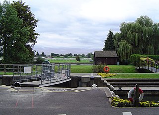
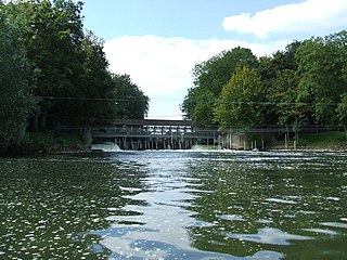
Old Windsor Lock is a lock on the River Thames in England on the right bank beside Old Windsor, Berkshire. The lock marks the downstream end of the New Cut, a meander cutoff built in 1822 by the Thames Navigation Commissioners which created Ham Island. The lock and a wider footbridge give access to the island. Two weirs are associated; the smaller adjoins and the larger is upstream. The lock is the ninth lowest of the forty-five on the river.

Romney Lock is a lock on the River Thames in England near Windsor and Eton, about half a mile downstream of Windsor Bridge. It is on the Windsor side of the river next to a boatyard and adjoins Romney Island, a long strip-shaped ait in the middle of the river. The first lock was built by the Thames Navigation Commission in 1798.
Boveney Lock is a lock on the River Thames situated on the Buckinghamshire bank opposite the Windsor Racecourse and close to Eton Wick. Boveney is a village a little way upstream on the same side. The lock was first built in 1838 by the Thames Navigation Commission. The lock was rebuilt in 1898 closer to the Buckinghamshire bank, and a set of boat rollers were installed on the old site.

Black Potts Railway Bridge carries the railway from London (Waterloo) to Windsor, Berkshire across the River Thames. The Staines to Windsor & Eton Line terminates immediately after the bridge at Windsor and Eton Riverside railway station. The bridge crosses the Thames on the reach above Old Windsor Lock, shortly before Romney Lock.
Hamhaugh Island is an island, historically known simply as Stadbury, in the River Thames in England south of Shepperton Lock, in Shepperton, Surrey.

Hollyhock Island is an inhabited island in the River Thames in England on the reach between Bell Weir Lock and Penton Hook Lock.
Friary Island is an island in the River Thames in England on the reach above Bell Weir Lock, on the approach to Old Windsor Lock at Wraysbury, Berkshire. It is just across the river from Old Windsor, where there was a friary from which it took its name.
Sumptermead Ait is an island in the River Thames in England on the reach above Old Windsor Lock, near Datchet, Berkshire. The island is a thin wooded strip separated by a narrow channel on the Datchet side. In 1995 a Thames side path was created here for the diverted Thames Path.
Firework Ait is an islet in the River Thames in England on the reach above Romney Lock known as the Windsor and Eton reach, Berkshire. It is the smallest island on the Thames with an official map-published name.

Clewer Mill Stream is a narrow twisting backwater of the River Thames near Windsor, Berkshire, England, which leaves the main river at Bush Ait and rejoins just above Queen Elizabeth Bridge. It is about 1.5 miles long. Clewer Mill Stream is named after the watermill that it once drove.
Dr. Julius Grant was a British forensic scientist and intelligence officer.
Lion Island is a small uninhabited island in the River Thames in England on the reach above Old Windsor Lock, near Old Windsor, Berkshire. The island is a thin wooded strip separated by a narrow channel on the north bank. It is just above Old Windsor Weir and the head of New Cut which leads to Old Windsor Lock.

Black Boy Island is an uninhabited island in the River Thames in England between the villages of Medmenham, Buckinghamshire and Hurley, Berkshire. It is situated alongside the small hamlet of Frogmill, on the southern side of the stretch of river above Hurley Lock, and is within the Royal Borough of Windsor and Maidenhead unitary authority.

Black Potts Ait is an island in the River Thames in England near Windsor, Berkshire. It is on the reach between Old Windsor Lock and Romney Lock and carries Black Potts Railway Bridge

Datchet Bridge, also known as The Divided Bridge, was a road bridge which crossed the River Thames at Datchet from 1706 until it was demolished in 1848. It was situated on the reach between Old Windsor Lock and Romney Lock and linked Windsor on the Berkshire bank to Datchet on the Buckinghamshire side. The bridge replaced a ferry service which had operated at the site since at least the middle of the 13th century.