Freiberg is a university and former mining town in Saxony, Germany. It is a Große Kreisstadt and the administrative centre of Mittelsachsen district.

U2 is a line of the Berlin U-Bahn. The U2 line starts at Pankow S-Bahn station, runs through the eastern city centre (Alexanderplatz) to Potsdamer Platz, the western city centre and finally to the Ruhleben terminal station.

Schöneberg is a locality of Berlin, Germany. Until Berlin's 2001 administrative reform it was a separate borough including the locality of Friedenau. Together with the former borough of Tempelhof it is now part of the new borough of Tempelhof-Schöneberg.

Rheinböllen is a town in the Rhein-Hunsrück-Kreis (district) in Rhineland-Palatinate, Germany. It belongs to the Verbandsgemeinde Simmern-Rheinböllen, whose seat is in Simmern. It was the seat of the former Verbandsgemeinde Rheinböllen.

Wertheim was a large department store chain in pre-World War II Germany. It was founded by Georg Wertheim and operated various stores in Berlin, one in Rostock, one in Stralsund, and one in Breslau. It was Aryanized under the Nazis.

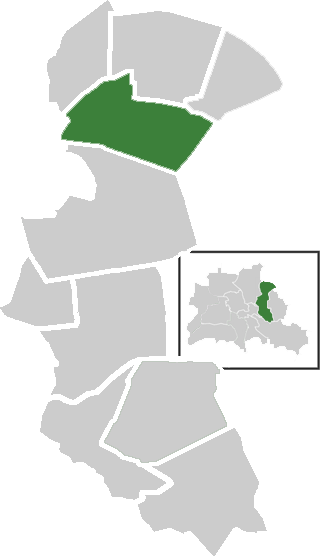
Friedrichstadt was an independent suburb of Berlin, and is now a historical neighbourhood of the city itself. The neighbourhood is named after the Prussian king Frederick I.

Erkner is a town in the Oder-Spree District of Brandenburg, Germany, located on the south-eastern edge of the German capital city Berlin.

Leipziger Straße is a major thoroughfare in the central Mitte district of Berlin, capital of Germany. It runs from Leipziger Platz, an octagonal square adjacent to Potsdamer Platz in the west, to Spittelmarkt in the east. Part of the Bundesstraße 1 highway, it is today one of the city's main east–west road links.
Leipziger Platz is an octagonal square in the center of Berlin. It is located along Leipziger Straße just east of and adjacent to the Potsdamer Platz.

Mitte is a central section of Berlin, Germany, in the eponymous borough of Mitte. Until 2001, it was itself an autonomous district.

Neukölln, until 1920 an independent city, is a large inner-city quarter (Ortsteil) of Berlin in the homonymous borough (Bezirk) of Neukölln, including the historic village of Alt-Rixdorf and numerous Gründerzeit apartment blocks. With 166,714 inhabitants (2018) the Ortsteil is the most densely populated of Berlin. It was originally characterized by mostly working-class inhabitants and later a relatively high percentage of immigrants, especially of Turkish and Russian descent, but since the turn of the millennium an influx of students, creatives, and western immigrants has led to gentrification.
Neu-Hohenschönhausen is a German locality (Ortsteil) in the borough (Bezirk) of Lichtenberg, Berlin. Until 2001 it was part of the former Hohenschönhausen borough.

The Berlin Fortress was the fortification of the historic city of Berlin. Construction started in 1650. The ramparts, walls, moats and glacis of the 17th-century bastion fort ran around the historic city limits. The demolition of its ramparts began in 1740.

Mühlendamm is a major thoroughfare in the central Mitte district of Berlin, Germany. It runs from the historic Cölln and Fischerinsel quarters to the Molkenmarkt square of Alt-Berlin via the Mühlendammbrücke crossing the Spree river. Named after several watermills at the site, a historic causeway was first laid out at this location about 1200 and became the nucleus of the late medieval city foundation. The current prestressed concrete bridge was built in 1968. It is part of an east–west road link to Berlin's city centre and the Bundesstraße 1 highway.

The Adlergestell in the Berlin district of Treptow-Köpenick is the longest road in Berlin at 11.9 kilometers. It runs from the district of Niederschöneweide to the district of Schmöckwitz on the southeastern outskirts of the city. The Berlin–Görlitz railway runs parallel to the Adlergestell.

Alte Messe Leipzig is the circa 50 hectares site in the southeastern part of Leipzig's district Mitte, where from 1920 until 1991 the technical exhibitions of the Leipzig Trade Fair took place, as well as the buildings that stand on it – but not the trade fair itself, which found a new home at a new site in the northern part of Leipzig. Since 1996 there has been no trade fair activity on the old site.
Karl-Heine-Strasse is a radial road in the west of Leipzig marking the boundary between the current boroughs of Leipzig-Plagwitz and Leipzig-Lindenau . 2.01 km (1.2 mi) long, it is named after the industrialist Karl Heine.
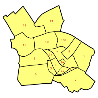
![Neighborhoods in Berlin-Mitte: Old Colln [1] (with Museum Island [1a], Fisher Island [1b]), Alt-Berlin [2] (with Nikolaiviertel [2a]), Friedrichswerder [3], Neukolln am Wasser [4], Dorotheenstadt [5], Friedrichstadt [6], Luisenstadt [7], Stralauer Vorstadt (with Konigsstadt) [8], Alexanderplatz Area (Konigsstadt and Altberlin) [9], Spandauer Vorstadt [10] (with Scheunenviertel [10a]), Friedrich-Wilhelm-Stadt [11], Oranienburger Vorstadt [12], Rosenthaler Vorstadt [13] Stadtviertel in Berlin-Mitte.png](http://upload.wikimedia.org/wikipedia/commons/thumb/7/7f/Stadtviertel_in_Berlin-Mitte.png/300px-Stadtviertel_in_Berlin-Mitte.png)