
Wedding is a locality in the borough of Mitte, Berlin, Germany. It was a separate borough in the north-western inner city until it was fused with Tiergarten and Mitte in Berlin's 2001 administrative reform. At the same time the eastern half of the former borough of Wedding—on the other side of Reinickendorfer Straße—was separated as the new locality of Gesundbrunnen.

Mitte is the first and most central borough of Berlin. The borough consists of six sub-entities: Mitte proper, Gesundbrunnen, Hansaviertel, Moabit, Tiergarten and Wedding.

Moabit is an inner city locality in the borough of Mitte, Berlin, Germany. As of 2022, about 84,000 people lived in Moabit. First inhabited in 1685 and incorporated into Berlin in 1861, the former industrial and working-class neighbourhood is fully surrounded by three watercourses, which define its present-day border. Between 1945 and 1990, Moabit was part of the British sector of West Berlin and directly bordered East Berlin.

Bernauer Straße is a street of Berlin situated between the localities of Gesundbrunnen and Mitte, today both belonging to the Mitte borough. It runs from the Mauerpark at the corner of Prenzlauer Berg to the Nordbahnhof. The street's name refers to the town of Bernau bei Berlin, situated in Brandenburg.

The Berlin border crossings were border crossings created as a result of the post-World War II division of Germany. Prior to the construction of the Berlin Wall in 1961, travel between the Eastern and Western sectors of Berlin was completely uncontrolled, although restrictions were increasingly introduced by the Soviet and East German authorities at major crossings between the sectors. This free access, especially after the closure of the Inner German border, allowed the Eastern Bloc emigration and defection to occur. East German officials, humiliated by this mass defection, subsequently chose to erect the Berlin Wall in order to prevent residents from leaving East Germany.

Oranienburger Straße is a street in central Berlin. It is located in the borough of Mitte, north of the River Spree, and runs south-east from Friedrichstraße to Hackescher Markt.

The Invalidenstraße is a street in Berlin, Germany. It runs east to west for three kilometers (1.9 mi) through the districts of Mitte and Moabit. The street originally connected three important railway stations in the northern city centre: the Stettiner Bahnhof, the Hamburger Bahnhof and the Lehrter Bahnhof, the present-day Berlin Hauptbahnhof.
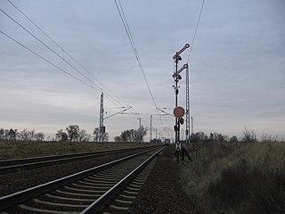
The Berlin Northern Railway is a 223-kilometre-long main line route, that runs from Berlin via Neustrelitz and Neubrandenburg to Stralsund on the Baltic Sea coast. Nowadays, long-distance and regional traffic on the Nordbahn is routed at Hohen Neuendorf onto the Berlin Outer Ring to the Karower Kreuz and on to Berlin Main Station or Berlin-Lichtenberg.

Mitte is a central section of Berlin, Germany, in the eponymous borough of Mitte. Until 2001, it was itself an autonomous district.

Gesundbrunnen is a locality (Ortsteil) of Berlin in the borough (Bezirk) of Mitte. It was created as a separate entity during the 2001 administrative reform, formerly the eastern half of the former Wedding district and locality. Gesundbrunnen has the highest percentage of non-German residents of any Berlin locality, at 35.1% as of the end of 2008.

The old Berlin Nordbahnhof was a short-lived passenger railway terminus in Berlin, Germany. It was situated in Prenzlauer Berg, close to the borders with Gesundbrunnen, in the area of the "Mauerpark".

The Berlin Inner Ring road is a beltway route of major roads around the historic city centre of Berlin encompassing the boroughs of Mitte, Pankow and Friedrichshain-Kreuzberg. It is named "Inner Ring" to distinguish it from both the wider City Ring (Stadtring) road including the Bundesautobahn 100 sections and the outer Berlin Ring orbital motorway.

The Berlin Customs Wall was a ring wall around the historic city of Berlin, between 1737 and 1860; the wall itself had no defence function but was used to facilitate the levying of taxes on the import and export of goods (tariffs), which was the primary income of many cities at the time.

Schwedter Straße, named after the town of Schwedt/Oder, is an inner-city road in the Mitte and Prenzlauer Berg districts of Berlin. It partially forms the border between both quarters and crosses Mauerpark at the site of the former Berlin Wall.
Feuerland was a popular 19th-century designation for the industrial nucleus of Berlin. It was located in the historic Oranienburger Vorstadt section of Berlin in today’s district Berlin-Mitte. The word literally means “land of fire”, but it is also a play on the German name for Tierra del Fuego.
The Ackerstraße is a street in Berlin which runs northwest from near the Liesenstraße – Scheringstraße traffic circle in Gesundbrunnen to Invalidenstraße, where it turns south, terminating at the Linienstraße in Mitte.

Olga Segler was a German woman who died of injuries as a result of crossing the Berlin Wall.
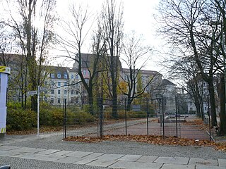
Spandauer Vorstadt is a historic district in what is now the Mitte district of Berlin.

Heinrich Wilhelm Krausnick was a German lawyer and Lord Mayor of Berlin in two terms from 1834 until 1848, and again in 1850 until 1862.

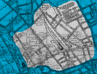
![Neighborhoods in Berlin-Mitte: Old Colln [1] (with Museum Island [1a], Fisher Island [1b]), Alt-Berlin [2] (with Nikolaiviertel [2a]), Friedrichswerder [3], Neukolln am Wasser [4], Dorotheenstadt [5], Friedrichstadt [6], Luisenstadt [7], Stralauer Vorstadt (with Konigsstadt) [8], Alexanderplatz Area (Konigsstadt and Altberlin) [9], Spandauer Vorstadt [10] (with Scheunenviertel [10a]), Friedrich-Wilhelm-Stadt [11], Oranienburger Vorstadt [12], Rosenthaler Vorstadt [13] Stadtviertel in Berlin-Mitte.png](http://upload.wikimedia.org/wikipedia/commons/thumb/7/7f/Stadtviertel_in_Berlin-Mitte.png/250px-Stadtviertel_in_Berlin-Mitte.png)

