Berlin Customs Wall

Last updated
Berlin Customs Wall around 1855 Karte berlin akzisemauer.png
Berlin Customs Wall around 1855

The Berlin Customs Wall (German: "Berliner Zoll- und Akzisemauer", literally Berlin customs and excise wall [1] ) was a ring wall around the historic city of Berlin, between 1737 and 1860; the wall itself had no defence function but was used to facilitate the levying of taxes on the import and export of goods (tariffs) which was the primary income of many cities at the time.

Contents

History

The wall was erected after the old Berlin Fortress was demolished in 1734; the walls of the latter had already started to crumble and its military function was questionable. Frederick William I of Prussia ordered the construction of stockades around the city which were completed in 1737 – the new ring fence incorporated the existing northern "palisade line" built in 1705. The location of this oldest stockade is recalled today by the street name "Linienstraße" (line street). Few parts of this original customs wall were stone-built.

The original customs wall had 14 city gates which were mostly named after the city to which the ensuing road led. Additionally, the river Spree was blocked with customs gates called "Oberbaum" (upper beam) and "Unterbaum" (lower beam) after the heavy tree trunks, covered in metal spikes, that were used as booms to block the river at night to prevent smuggling. The new wall engirded not only the city of Berlin and its suburbs but also some rural land in the east and south.

Wall monument made from excavated stones Berliner Akzisemauer.jpg
Wall monument made from excavated stones

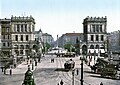
With the growth of Berlin, the stockades and gates were moved as dictated by circumstances during the following decades. Between 1786 and 1802 the wooden stockades were replaced by stone walls at a height of 4 metres (10'). Also, various gates were rebuilt in an imposing style, one notable example being the Brandenburg Gate. In the middle of the century more gates were added to meet the increased transport requirements – these included New Gate (1832), Anhalt Gate (1839/1840), Köpenick Gate (1842) and Water Gate (1848).

The middle of the century was marked by new railway lines terminating in stations built in front of the wall usually near one of its gates. This was the case with Potsdam Station (1841), Anhalt Station (1842), Stettin Station (1842), Hamburg Station (1846) – only Frankfurt Station (1842) was built just inside the ring wall. An interconnecting railway line, the ("Berliner Verbindungsbahn") for goods and military transport, was built in 1851 linking the terminal stations and thus turning Berlin into a central transport hub for Prussia and the German Customs Union.

With the rise of Berlin, new suburbs were built outside the Customs Wall, which increasingly became a hindrance to the continued development of the city. In 1860 the Customs Wall was removed and on 1 January 1861 Berlin amalgamated its suburbs resulting in a doubling of the city's population. The remaining walls were demolished for the most part between 1867 and 1870 – including most of the gates. Only the Brandenburg Gate remains today.

With the old walls out of the way, the city developed quickly almost doubling in population over the following decade. The interconnecting railway line (on the southern and western sides) was replaced by the circle line railway in 1871, and the existing railway track was then used by horsecar lines. The route of the southern lines was used for the first electric metro line in 1900, which is now the U1 (Berlin U-Bahn). Its metro stations Silesian Gate (Schlesisches Tor), Cottbus Gate (Kottbusser Tor), Halle Gate (Hallesches Tor), and former Stralau Gate (Stralauer Tor) are a reminder of its heritage. The following streets follow the original route of the customs wall: Stresemannstraße (former Königgrätzer Straße ), Marchlewskistraße, Friedenstraße, Prenzlauer Berg avenue, part of Prenzlauer Allee, Torstraße, Hannoversche Straße, Charitéstraße, part of Reinhardtstraße, and Ebertstraße.

Gates

The eighteen city gates and two river gates are still visible on the map, their names having been given to squares and streets. In clockwise order these are:

Related Research Articles

<span class="mw-page-title-main">Potsdamer Platz</span> Public square and traffic intersection in Berlin, Germany

Potsdamer Platz is a public square and traffic intersection in the center of Berlin, Germany, lying about 1 km (1,100 yd) south of the Brandenburg Gate and the Reichstag, and close to the southeast corner of the Tiergarten park. It is named after the city of Potsdam, some 25 km (16 mi) to the south west, and marks the point where the old road from Potsdam passed through the city wall of Berlin at the Potsdam Gate. Initially, the open area near the city gate was used for military drills and parades. In the 19th into the 20th century, it developed from an intersection of suburban thoroughfares into the most bustling traffic intersection in Europe. The area was totally destroyed during World War II and then left desolate during the Cold War era when the Berlin Wall bisected its location. Since German reunification, Potsdamer Platz has been the site of major redevelopment projects.

<span class="mw-page-title-main">U2 (Berlin U-Bahn)</span> Underground line in Berlin

U2 is a line of the Berlin U-Bahn. The U2 line starts at Pankow S-Bahn station, runs through the eastern city centre (Alexanderplatz) to Potsdamer Platz, the western city centre and finally to the Ruhleben terminal station.

<span class="mw-page-title-main">U7 (Berlin U-Bahn)</span> Rail line on the Berlin U-Bahn

The U7 is a rail line on the Berlin U-Bahn. It runs completely underground for a length of 31.8 kilometres (19.8 mi) through 40 stations and connects Spandau, via Neukölln, to Gropiusstadt and Rudow. The U7 was originally the south-eastern branch of the Nord-Süd-Bahn (U6) that ran between the branching point at Belle-Alliance-Straße (Mehringdamm) and Grenzallee; however, in the 1960s, this stretch was separated from the rest of the line and extended at each end to form a new line.

<span class="mw-page-title-main">U8 (Berlin U-Bahn)</span>

U8 is a line on the Berlin U-Bahn. It has 24 stations and is 18.1 km (11.2 mi) long. The U8 is one of three north–south Berlin U-Bahn lines, and runs from Wittenau to Neukölln via Gesundbrunnen. The original proposal was for a suspended monorail like the Wuppertal Schwebebahn.

<span class="mw-page-title-main">Friedrichshain</span> Quarter of Berlin in Germany

Friedrichshain is a quarter (Ortsteil) of the borough of Friedrichshain-Kreuzberg in Berlin, Germany. From its creation in 1920 until 2001, it was a freestanding city borough. Formerly part of East Berlin, it is adjacent to Mitte, Prenzlauer Berg, Kreuzberg and Lichtenberg.

<span class="mw-page-title-main">Alfred Grenander</span> Swedish architect (1863–1931)

Alfred Frederik Elias Grenander was a Swedish architect, who became one of the most prominent engineers during the first building period of the Berlin U-Bahn network in the early twentieth century.

<span class="mw-page-title-main">Hallesches Tor (Berlin U-Bahn)</span> Station of the Berlin U-Bahn

Hallesches Tor is a Berlin U-Bahn station in the central Kreuzberg quarter, served by lines U1, U3, and U6. It is named after the historic Hallsches Tor of the Berlin Customs Wall, erected in the 18th century.

<span class="mw-page-title-main">Oberbaum Bridge</span> Landmark crossing of the River Spree in Berlin, Germany

The Oberbaum Bridge is a double-deck bridge crossing Berlin, Germany's River Spree, considered one of the city's landmarks. It links Friedrichshain and Kreuzberg, former boroughs that were divided by the Berlin Wall, and has become an important symbol of Berlin's unity.

<span class="mw-page-title-main">Rosa-Luxemburg-Platz (Berlin U-Bahn)</span> Station of the Berlin U-Bahn

Rosa-Luxemburg-Platz is a Berlin U-Bahn station located on the U2. It was formerly called Schönhauser Tor and is located at the foot of Schönhauser Allee, at the corner of Torstraße. The color of the station is yellow.

<span class="mw-page-title-main">Berlin Anhalter Bahnhof</span> Formerly terminus and today underground S-Bahn station in Berlin

The Anhalter Bahnhof is a former railway terminus in Berlin, Germany, approximately 600 m (2,000 ft) southeast of Potsdamer Platz. Once one of Berlin's most important railway stations, it was severely damaged in World War II, and finally closed for traffic in 1952, when the GDR-owned Deutsche Reichsbahn rerouted all railway traffic between Berlin and places in the GDR avoiding the West Berlin area. The station's name lives on in the Berlin S-Bahn station of the same name, opened in October 1939 as part of the North-South S-Bahn link.

<span class="mw-page-title-main">Stralauer Tor (Berlin U-Bahn)</span>

Stralauer Tor was a Berlin U-Bahn station in Berlin-Friedrichshain. It operated between Warschauer Straße and Schlesisches Tor stations on today's U1. Following its destruction in World War II it was never rebuilt and is one of three Berlin U-Bahn stations to have been abandoned after having previously been in service.

<span class="mw-page-title-main">Mitte (locality)</span> Quarter of Berlin in Germany

Mitte is a central section of Berlin, Germany, in the eponymous borough of Mitte. Until 2001, it was itself an autonomous district.

<span class="mw-page-title-main">Berlin Nord-Süd Tunnel</span> Berlin metropolitan railway line

The North–South S-Bahn Tunnel is the central section of the North–South transversal Berlin S-Bahn connection crossing the city centre. It is not to be confused with the Tunnel Nord-Süd-Fernbahn, the central tunnel part of the North–South main line used by intercity and regional trains. The S-Bahn North–South line encompasses the route from Bornholmer Straße and Gesundbrunnen via Friedrichstraße and Anhalter Bahnhof to Papestraße and Schöneberg.

<span class="mw-page-title-main">Schönhauser Allee</span>

Schönhauser Allee in Berlin is one of the most important streets of the Prenzlauer Berg district.

<span class="mw-page-title-main">Oranienburger Vorstadt</span>

Oranienburger Vorstadt is a historic district of Berlin in what is now the northwestern part of Mitte and the adjacent Gesundbrunnen area, in the modern Mitte borough.

<span class="mw-page-title-main">Schwedter Straße</span>

Schwedter Straße, named after the town of Schwedt/Oder, is an inner-city road in the Mitte and Prenzlauer Berg districts of Berlin. It partially forms the border between both quarters and crosses Mauerpark at the site of the former Berlin Wall.

The following is a timeline of the history of the city of Berlin, Germany.

<span class="mw-page-title-main">History of the Berlin U-Bahn</span>

The Berlin U-Bahn originated in 1880 with Werner Siemens' idea to build an urban railway in Berlin. During the nine years after the German Empire was founded, the city's population grew by over one-third and traffic problems increased. In 1896, Siemens & Halske began to construct the first stretch of overhead railway. On 1 April 1897, the company began construction of an electric underground railway. The Berliner Verkehrs Aktiengesellschaft (BVG) was formed in 1928, and took over further construction and operation of the network. In 1938, the company was renamed Berlin Transport Company; the original acronym, however, remained. Since 1994, the BVG has been a public company.

<span class="mw-page-title-main">Hallesches Tor</span>

The Hallesches Tor was located in today's Berlin district Kreuzberg south of Mehringplatz. Today, as a historic monument listed underground station on the site of the former gate bears the name Hallesches Tor. It is a major transfer point for the underground lines U1/U3 and U6 as well as the bus lines 248 and M41. The station is connected by the Hallesche-Tor-Brücke with the Blücherplatz to the south. The Amerika-Gedenkbibliothek and the nearby Jewish Museum contribute to the heavy visitor traffic in the area around the Hallesches Tor.

<span class="mw-page-title-main">Rosenthaler Platz</span> Square in Berlin, Germany

Rosenthaler Platz in Berlin's Mitte district, district Mitte, forms a crossroads where Rosenthaler Strasse, Brunnenstrasse and Weinbergsweg meet Torstrasse, and is therefore not a square in the true sense of the word. It is located on the site of the former Rosenthaler Tor of the Berlin customs wall, from which a road led to the village of Rosenthal. This gate was one of the few through which Jews were allowed to enter Berlin until the 19th century. Those who were not allowed to enter could stay overnight in a special Jewish hostel.

References

  1. the German term had been originally "Akzisemauer" / excise wall but with the fading knowledge of the term "excise" most references incorporate "Zoll" / Customs to flag the function

Further reading

52°31′42″N13°22′48″E / 52.528468°N 13.379933°E / 52.528468; 13.379933