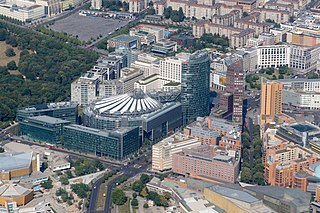
Potsdamer Platz is a public square and traffic intersection in the center of Berlin, Germany, lying about 1 km (1,100 yd) south of the Brandenburg Gate and the Reichstag, and close to the southeast corner of the Tiergarten park. It is named after the city of Potsdam, some 25 km (16 mi) to the south west, and marks the point where the old road from Potsdam passed through the city wall of Berlin at the Potsdam Gate. Initially, the open area near the city gate was used for military drills and parades. In the 19th into the 20th century, it developed from an intersection of suburban thoroughfares into the most bustling traffic intersection in Europe. The area was totally destroyed during World War II and then left desolate during the Cold War era when the Berlin Wall bisected its location. Since German reunification, Potsdamer Platz has been the site of major redevelopment projects.

U1 is a line on the Berlin U-Bahn, which is 8.8 kilometres (5.5 mi) long and has 13 stations. Its traditional line designation was BII. It runs east–west and its eastern terminus is Warschauer Straße S-Bahn station where it connects to the Schlesische Bahn. From there it runs through Kreuzberg via Gleisdreieck and Wittenbergplatz on to the Kurfürstendamm.

U2 is a line of the Berlin U-Bahn. The U2 line starts at Pankow S-Bahn station, runs through the eastern city centre (Alexanderplatz) to Potsdamer Platz, the western city centre and finally to the Ruhleben terminal station.

U6 is a 19.9 km (12.4 mi) long rapid transit line on the Berlin U-Bahn with 29 stations. It runs in a north-south direction from the Berlin locality of Tegel in the north via Friedrichstraße to Mariendorf, a locality in the southern part of the city. It is one of the five large profile ("Großprofil") lines.

Hallesches Tor is a Berlin U-Bahn station in the central Kreuzberg quarter, served by lines U1, U3, and U6. It is named after the historic Hallsches Tor of the Berlin Customs Wall, erected in the 18th century.
The Oberbaum Bridge is a double-deck bridge crossing Berlin, Germany's River Spree, considered one of the city's landmarks. It links Friedrichshain and Kreuzberg, former boroughs that were divided by the Berlin Wall, and has become an important symbol of Berlin's unity.

The Potsdamer Bahnhof is a former railway terminus in Berlin, Germany. It was the first railway station in Berlin, opening in 1838. It was located at Potsdamer Platz, about 1 km south of the Brandenburg Gate, and kick-started the transformation of Potsdamer Platz from an area of quiet villas near the south-east corner of the Tiergarten park into the bustling focal point that it eventually became. For more than a century it was the terminus for long-distance and suburban trains. Also located at this spot were underground stations on the Berlin U-Bahn and S-Bahn, and today's new underground Regionalbahnhof, known as Bahnhof Potsdamer Platz, while the short-lived M-Bahn crossed the site of the former terminus.

Gneisenaustraße is a station on the U7 in Berlin, Germany.

The Berlin border crossings were border crossings created as a result of the post-World War II division of Germany. Prior to the construction of the Berlin Wall in 1961, travel between the Eastern and Western sectors of Berlin was completely uncontrolled, although restrictions were increasingly introduced by the Soviet and East German authorities at major crossings between the sectors. This free access, especially after the closure of the Inner German border, allowed the Eastern Bloc emigration and defection to occur. East German officials, humiliated by this mass defection, subsequently chose to erect the Berlin Wall in order to prevent residents from leaving East Germany.

The Anhalter Bahnhof is a former railway terminus in Berlin, Germany, approximately 600 m (2,000 ft) southeast of Potsdamer Platz. Once one of Berlin's most important railway stations, it was severely damaged in World War II, and finally closed for traffic in 1952, when the GDR-owned Deutsche Reichsbahn rerouted all railway traffic between Berlin and places in the GDR avoiding the West Berlin area. The station's name lives on in the Berlin S-Bahn station of the same name, opened in October 1939 as part of the North-South S-Bahn link.

Stralauer Tor was a Berlin U-Bahn station in Berlin-Friedrichshain. It operated between Warschauer Straße and Schlesisches Tor stations on today's U1. Following its destruction in World War II it was never rebuilt and is one of three Berlin U-Bahn stations to have been abandoned after having previously been in service.

Berlin Potsdamer Platz is a railway station in Berlin. It is completely underground and situated under Potsdamer Platz in central Berlin. Regional and S-Bahn services call at the station, and it is also served by U-Bahn line U2.
The Landwehr Canal, is a 10.7-kilometre-long (6.6 mi) canal parallel to the Spree river in Berlin, Germany, built between 1845 and 1850 to plans by Peter Joseph Lenné. It connects the upper part of the Spree at the eastern harbour in Friedrichshain with its lower part in Charlottenburg, flowing through Kreuzberg and Tiergarten.

Julius-Leber-Brücke is a railway station in the Schöneberg district of Berlin. Located under a bridge over the cutting created for the Berlin-Potsdam-Magdeburg railway. It was officially opened on 2 May 2008 and is served by the S-Bahn line S1.

The North–South S-Bahn Tunnel is the central section of the North–South transversal Berlin S-Bahn connection crossing the city centre. It is not to be confused with the Tunnel Nord-Süd-Fernbahn, the central tunnel part of the North–South main line used by intercity and regional trains. The S-Bahn North–South line encompasses the route from Bornholmer Straße and Gesundbrunnen via Friedrichstraße and Anhalter Bahnhof to Papestraße and Schöneberg.

The Wannsee Railway is a suburban railway in Berlin running from Potsdamer Platz via the Ring line station of Schöneberg to Wannsee station on Großer Wannsee, a lake after which it is named. Today it is a section of the Berlin S-Bahn line S1.

The Berlin Customs Wall was a ring wall around the historic city of Berlin, between 1737 and 1860; the wall itself had no defence function but was used to facilitate the levying of taxes on the import and export of goods (tariffs), which was the primary income of many cities at the time.

The Berlin U-Bahn originated in 1880 with Werner Siemens' idea to build an urban railway in Berlin. During the nine years after the German Empire was founded, the city's population grew by over one-third and traffic problems increased. In 1896, Siemens & Halske began to construct the first stretch of overhead railway. On 1 April 1897, the company began construction of an electric underground railway. The Berliner Verkehrs Aktiengesellschaft (BVG) was formed in 1928, and took over further construction and operation of the network. In 1938, the company was renamed Berlin Transport Company; the original acronym, however, remained. Since 1994, the BVG has been a public company.

The Wassertorplatz in the Berlin district of Kreuzberg is named after the historic Wassertor and is located about 200 meters west of the Kottbusser Tor. The place is currently divided by the heavily frequented Skalitzer Straße and the subway line U1, which runs over the middle strip of Skalitzer Straße as a raised railway.
The tracks of the Berlin subway are lines operated in the line traffic, operating distances, which serve only internal purposes, turn-off and turning plants and plants in the operating farms.


