Hallesches Tor (Berlin U-Bahn)

Last updated

Hallesches Tor
U-Bahn.svg
U Hallesches Tor Berlin.jpg
View of the station from Hallesches-Tor-Brücke
General information
LocationHallesches Ufer/Hallesches-Tor-Brücke
Kreuzberg, Berlin
Germany
Coordinates 52°29′52″N13°23′28″E / 52.49778°N 13.39111°E / 52.49778; 13.39111 Coordinates: 52°29′52″N13°23′28″E / 52.49778°N 13.39111°E / 52.49778; 13.39111
Owned by Berliner Verkehrsbetriebe
Operated by Berliner Verkehrsbetriebe
Platforms
Tracks4
Connections
  • BUS-Logo-BVG.svg : 248, N1, N42
  • MetroBus.svg : M41
Construction
Structure type
  • Elevated (U1/U3)
  • Underground (U6)
Bicycle facilitiesYes
Disabled accessYes
Other information
Fare zone VBB-Logo.svg : Berlin A/5555 [1]
History
Opened18 February 1902;121 years ago (1902-02-18) (U1/3 level)
30 January 1923;100 years ago (1923-01-30) (U6 level)
Services
Preceding station Berlin U-Bahn Following station
Möckernbrücke
towards Uhlandstraße
Berlin U1.svg Prinzenstraße
Möckernbrücke
towards Krumme Lanke
Berlin U3.svg
Kochstraße
towards Alt-Tegel
Berlin U6.svg Mehringdamm
Location
Berlin location map.svg
Red pog.svg
Hallesches Tor
Location within Berlin

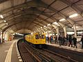
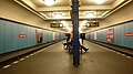
Hallesches Tor is a Berlin U-Bahn station in the central Kreuzberg quarter, served by lines U1, U3, and U6. It is named after the historic Hallsches Tor (Halle Gate) of the Berlin Customs Wall, erected in the 18th century.

Contents

Overview

The historic gate of the Customs Wall, laid out from 1737 onwards to replace the medieval city fortifications, marked the southern tip of the Friedrichstadt neighbourhood. It was located at the southern end of Friedrichstraße and the Rondell (renamed Belle-Alliance-Platz in 1815 and Mehringplatz in 1946). Neighbouring gates were on Potsdamer Platz in the west and on Wassertorplatz (Water Gate) in the east, where the present course of the U1 viaduct roughly corresponds to the former city wall. South of the gate, a wooden bridge led across the Landwehr Canal; from here the road ran via Tempelhof to the city of Halle, part of Brandenburg-Prussia since 1680. The present-day stone bridge was built between 1874 and 1876.

Construction, 1901 Hallesches Tor, 1901.jpg
Construction, 1901

The U1 and U3 platforms, on an elevated railway at the northern banks of the Landwehr Canal, opened on 18 February 1902 with Berlin's first U-Bahn line ( Stammstrecke ) from Stralauer Tor to Potsdamer Platz. The underground U6 (then Linie C) platform was finished on 30 January 1923, linked by a pedestrian tunnel. Even today, changing from one platform to the other is (for Berlin) quite a long distance. [2]

The station was severely damaged by the bombing of Berlin in World War II; both parts of the station had to be shut down due to numerous bombing hits and electricity shortage in April 1945. U-Bahn service at the underground platform already resumed on 4 July 1945; a provisional upper platform opened in October. The viaduct was rebuilt by 1949, and the lower platform was elongated and refurbished in 1976.

The Amerika-Gedenkbibliothek on Blücherplatz and the Jewish Museum Berlin with its 1999 extension designed by Daniel Libeskind are nearby.

Related Research Articles

<span class="mw-page-title-main">Potsdamer Platz</span> Public square and traffic intersection in Berlin, Germany

Potsdamer Platz is a public square and traffic intersection in the center of Berlin, Germany, lying about 1 km (1,100 yd) south of the Brandenburg Gate and the Reichstag, and close to the southeast corner of the Tiergarten park. It is named after the city of Potsdam, some 25 km (16 mi) to the south west, and marks the point where the old road from Potsdam passed through the city wall of Berlin at the Potsdam Gate. After developing within the space of little over a century from an intersection of rural thoroughfares into the most bustling traffic intersection in Europe, it was totally destroyed during World War II and then left desolate during the Cold War era when the Berlin Wall bisected its former location. Since German reunification, Potsdamer Platz has been the site of major redevelopment projects.

<span class="mw-page-title-main">U1 (Berlin U-Bahn)</span> Rapid transit line in Berlin, Germany

U1 is a line on the Berlin U-Bahn, which is 8.8 kilometres (5.5 mi) long and has 13 stations. Its traditional line designation was BII. It runs east–west and its eastern terminus is Warschauer Straße S-Bahn station where it connects to the Schlesische Bahn. From there it runs through Kreuzberg via Gleisdreieck and Wittenbergplatz on to the Kurfürstendamm.

<span class="mw-page-title-main">U2 (Berlin U-Bahn)</span> Underground line in Berlin

U2 is a line of the Berlin U-Bahn. The U2 line starts at Pankow S-Bahn station, runs through the eastern city centre (Alexanderplatz) to Potsdamer Platz, the western city centre and finally to the Ruhleben terminal station.

<span class="mw-page-title-main">U6 (Berlin U-Bahn)</span>

U6 is a Berlin U-Bahn line, 19.9 km (12.4 mi) long line with 29 stations. It runs in a north-south direction from the Berlin locality of Tegel in the north via Friedrichstraße to Mariendorf, a locality in the southern part of the city. It is a so-called large profile ("Großprofil") line.

<span class="mw-page-title-main">Kottbusser Tor (Berlin U-Bahn)</span> Station of the Berlin U-Bahn

Kottbusser Tor is a Berlin U-Bahn station located on lines U1, U3, and U8. Many Berliners use the affectionate term Kotti.

<span class="mw-page-title-main">Möckernbrücke (Berlin U-Bahn)</span> Station of the Berlin U-Bahn

Möckernbrücke is a station of the Berlin U-Bahn network in the western Kreuzberg district, in the vicinity of Potsdamer Platz, named after a nearby bridge crossing the Landwehrkanal. It is served by lines U1, U3, and U7.

<span class="mw-page-title-main">Gleisdreieck (Berlin U-Bahn)</span> Berlin U-Bahn station

Gleisdreieck is an elevated Berlin U-Bahn station located on a viaduct in the Kreuzberg district, and served by lines U1, U2, and U3. The U1/U3 platform is at a higher level than, and perpendicular to, that of the U2.

<span class="mw-page-title-main">Oberbaum Bridge</span> Landmark crossing of the River Spree in Berlin, Germany

The Oberbaum Bridge is a double-deck bridge crossing Berlin's River Spree, considered one of the city's landmarks. It links Friedrichshain and Kreuzberg, former boroughs that were divided by the Berlin Wall, and has become an important symbol of Berlin's unity.

<span class="mw-page-title-main">Berlin Potsdamer Bahnhof</span> Railway station in Mitte, Germany

The Potsdamer Bahnhof is a former railway terminus in Berlin, Germany. It was the first railway station in Berlin, opening in 1838. It was located at Potsdamer Platz, about 1 km south of the Brandenburg Gate, and kick-started the transformation of Potsdamer Platz from an area of quiet villas near the south-east corner of the Tiergarten park into the bustling focal point that it eventually became. For more than a century it was the terminus for long-distance and suburban trains. Also located at this spot were underground stations on the Berlin U-Bahn and S-Bahn, and today's new underground Regionalbahnhof, known as Bahnhof Potsdamer Platz, while the short-lived M-Bahn crossed the site of the former terminus.

<span class="mw-page-title-main">Mendelssohn-Bartholdy-Park (Berlin U-Bahn)</span> Station of the Berlin U-Bahn

Mendelssohn-Bartholdy-Park is a Berlin U-Bahn station on line U2, located in the Tiergarten district at the border with Kreuzberg. Opened in 1998, the station is named after a small park east of the building, itself named in honor of the composer Felix Mendelssohn Bartholdy, commonly known as Felix Mendelssohn.

<span class="mw-page-title-main">Berlin border crossings</span> Post-WWII crossings in divided Berlin, Germany

The Berlin border crossings were border crossings created as a result of the post-World War II division of Germany. Prior to the construction of the Berlin Wall in 1961, travel between the Eastern and Western sectors of Berlin was completely uncontrolled, although restrictions were increasingly introduced by the Soviet and East German authorities at major crossings between the sectors. This free access, especially after the closure of the Inner German border, allowed the Eastern Bloc emigration and defection to occur. East German officials, humiliated by this mass defection, subsequently chose to erect the Berlin Wall in order to prevent residents from leaving East Germany.

<span class="mw-page-title-main">Berlin Anhalter Bahnhof</span> Formerly terminus and today underground S-Bahn station in Berlin

The Anhalter Bahnhof is a former railway terminus in Berlin, Germany, approximately 600 m (2,000 ft) southeast of Potsdamer Platz. Once one of Berlin's most important railway stations, it was severely damaged in World War II, and finally closed for traffic in 1952, when the GDR-owned Deutsche Reichsbahn rerouted all railway traffic between Berlin and places in the GDR avoiding the West Berlin area. The station's name lives on in the Berlin S-Bahn station of the same name, opened in October 1939 as part of the North-South S-Bahn link.

<span class="mw-page-title-main">Stralauer Tor (Berlin U-Bahn)</span>

Stralauer Tor was a Berlin U-Bahn station in Berlin-Friedrichshain. It operated between Warschauer Straße and Schlesisches Tor stations on today's U1. Following its destruction in World War II it was never rebuilt and is one of three Berlin U-Bahn stations to have been abandoned after having previously been in service.

<span class="mw-page-title-main">Pariser Platz</span>

Pariser Platz is a square in the historic center of Berlin, Germany, situated by the Brandenburg Gate at the end of the Unter den Linden. The square is named after the French capital of Paris to commemorate the anti-Napoleon Allies' victory at the Battle of Paris (1814), and is one of the main focal points of the city.

<span class="mw-page-title-main">Berlin Potsdamer Platz station</span>

Berlin Potsdamer Platz is a railway station in Berlin. It is completely underground and situated under Potsdamer Platz in central Berlin. Regional and S-Bahn services call at the station, and it is also served by U-Bahn line U2.

<span class="mw-page-title-main">Berlin Nord-Süd Tunnel</span>

The North–South S-Bahn Tunnel is the central section of the North–South transversal Berlin S-Bahn connection crossing the city centre. It is not to be confused with the Tunnel Nord–Süd Fernbahn, the central tunnel part of the North–South main line used by intercity and regional trains. The S-Bahn North–South line encompasses the route from Bornholmer Straße and Gesundbrunnen via Friedrichstraße and Anhalter Bahnhof to Papestraße and Schöneberg.

<span class="mw-page-title-main">Berlin Customs Wall</span>

The Berlin Customs Wall was a ring wall around the historic city of Berlin, between 1737 and 1860; the wall itself had no defence function but was used to facilitate the levying of taxes on the import and export of goods (tariffs) which was the primary income of many cities at the time.

The following is a timeline of the history of the city of Berlin, Germany.

<span class="mw-page-title-main">History of the Berlin U-Bahn</span> Aspect of history

The Berlin U-Bahn originated in 1880 with Werner Siemens' idea to build an urban railway in Berlin. During the nine years after the German Empire was founded, the city's population grew by over one-third and traffic problems increased. In 1896, Siemens & Halske began to construct the first stretch of overhead railway. On 1 April 1897, the company began construction of an electric underground railway. The Berliner Verkehrs Aktiengesellschaft (BVG) was formed in 1928, and took over further construction and operation of the network. In 1938, the company was renamed Berlin Transport Company; the original acronym, however, remained. Since 1994, the BVG has been a public company.

<span class="mw-page-title-main">Hallesches Tor</span>

The Hallesches Tor was located in today's Berlin district Kreuzberg south of Mehringplatz. Today, as a historic monument listed underground station on the site of the former gate bears the name Hallesches Tor. It is a major transfer point for the underground lines / and as well as the bus lines 248 and M41. The station is connected by the Hallesche-Tor-Brücke with the Blücherplatz to the south. The Amerika-Gedenkbibliothek and the nearby Jewish Museum contribute to the heavy visitor traffic in the area around the Hallesches Tor.

References

  1. "Alle Zielorte". Verkehrsverbund Berlin-Brandenburg. 1 January 2021. p. 62. Retrieved 5 May 2021.
  2. J. Meyer-Kronthaler: Berlins U-Bahnhöfe. be.bra Verlag (1996)