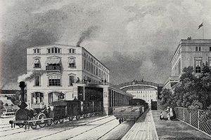
The terminus in 1850, already somewhat larger but even in this form it will eventually become unable to cope with growing trafficThe rebuilt Potsdamer Bahnhof - its new facade around 1900
The Potsdamer Bahnhof is a former railway terminus in Berlin, Germany. It was the first railway station in Berlin, opening in 1838. It was located at Potsdamer Platz, about 1km south of the Brandenburg Gate, and kick-started the transformation of Potsdamer Platz from an area of quiet villas near the south-east corner of the Tiergarten park into the bustling focal point that it eventually became. For more than a century it was the terminus for long-distance and suburban trains. Also located at this spot were underground stations on the Berlin U-Bahn and S-Bahn, and today's new underground Regionalbahnhof, known as Bahnhof Potsdamer Platz, while the short-lived M-Bahn crossed the site of the former terminus.
The Potsdamer Bahnhof was the Berlin terminus of the city's first railway, linking it with Potsdam. Begun in 1835, it was opened from the Potsdam end as far as Zehlendorf on 22 September 1838, and its entire length of 26km on 29 October. The first train was hauled by a British-built locomotive, the work of Robert Stephenson at his Newcastle-upon-Tyne works in 1835, and called Adler (Eagle). In 1848, the lines were extended west to Magdeburg, to link up with routes extending across the future German state. The whole area around the Berlin terminus became a major focus for urban growth after its opening. Five major streets eventually converged here, most having started out as mere rough tracks through the Tiergarten park and adjoining fields.
The first Potsdamer Bahnhof lasted until 1869, when it was superseded by a far grander structure in response to growing traffic, built by Julius Ludwig Quassowski (1824–1909) with five platforms, a trainshed roof that was 173m long and 36m wide, a booking hall with separate waiting rooms and facilities for four classes of ticket holders, and a separate entrance and reception area on the west side for visiting royalty. Opened on 30 August 1872, it eventually handled train services to and from Cologne, Paris, Frankfurt/Main, Strasbourg and Aix en Provence. By 1890 over 3 million people a year were using it, and it was holding its own against a larger rival down the road (the Anhalter Bahnhof).
Location of the main station and its Wannseebahn and Ringbahn appendices in 1910, shadowed with the situation of 1980–85
Still the facilities could not cope, and so in 1890–1891 two additional termini were built on either side of it for short-haul and suburban traffic: on the east side, the Ringbahnhof, opened on 1 April 1891 to serve the Ringbahn itself, the circular route skirting the city's perimeter with connections to all the main termini and open throughout its length since 15 November 1877; and the Wannsee Bahnhof on the west side, opened on 1 October 1891 for trains to Wannsee and the south western suburbs. Both these stations were located further south, with the north entries just north of the line Bernburger Straße.
In 1901, separate tracks for the suburban line along the Anhalter Bahn to Lichterfelde-Ost were built together with a number of new stations. The Berlin city terminus was moved from the Anhalter Bahnhof to the Potsdam Ringbahn station. This line was the first Berlin suburban line to be electrified with Third Rail, opened on 2 July 1903. Originally using 550VDC, it was converted to 800 V in April 1929, in the course of the "Grand Electrification" of the core of Berlin's city, Ring, and suburban lines.
The lines terminating in the Potsdamer Bahnhof Wannsee station and the mainline terminus had to wait until 15 May 1933 to be electrified. The Ringbahnhof ultimately handled many times as many passengers as the mainline terminus.
Although smaller than the Anhalter Bahnhof, the Potsdamer Bahnhof was much the busier of the two. By 1939, up to 83,000 people per day were using it, actually making it the busiest station in Berlin by a considerable distance. Since most of these were specifically using the Ringbahnhof, it gave the impression that the entire terminus was simply a suburban or commuter station handling exclusively short haul services, yet the main line services, including those to Paris and other French destinations, were definitely still running. The previous year, the terminus, together with the line from Potsdam, had reached its centenary, and the celebrations featured an operational replica of the "Adler" locomotive that had hauled the very first train 100 years previously (the original loco had been scrapped at Augsburg in 1857). The replica was the work of the DRG restoration workshop at Kaiserslautern in 1935. In 1939, the Wannsee Bahnhof on the west side closed, superseded by the new S-Bahn North-South Link described below.
World War II and its aftermath
The fate of the Potsdamer Bahnhof was determined by World War II, and yet even if the war had not occurred, major changes would still have taken place. Under the grand plan by Adolf Hitler, to transform Berlin into the Welthauptstadt (World Capital) Germania, to be realised by Albert Speer, the building would have ceased to be a railway terminus. The new North-South Axis, the linchpin of the plan, would have severed its approach tracks, leaving the terminus stranded on the wrong side of it. All trains arriving in Berlin would have run into either of two vast new stations located on the Ringbahn to the north and south of the centre respectively, to be known as Nordbahnhof (North Station) and Südbahnhof (South Station), located at Wedding and Südkreuz. The intended use of the Potsdamer Bahnhof has not been documented. In any event, things took a very different course.
During World War II the terminus, like most of Berlin, was devastated by Royal Air Force and US Air Force bombs and Soviet artillery shells. Despite some rubble clearance and emergency repairs, damage to rail infrastructure further out was so great that the mainline terminus never saw another train, it and the Ringbahnhof finally closed on 3 August 1944.
Shortly after the war's end the Ringbahnhof received a reprieve of sorts, temporarily reopening on 6 August 1945 as terminus of the Wannseebahn trains, while the U-Bahn and S-Bahn received extensive repairs, beginning with pumping out thousands of tonnes of water. The Ringbahnhof closed for good on 27 July 1946 after some fragmentary train workings had resumed along the U-Bahn and North-South Tunnel on 2 June. The services were extended further in 1951.
Potsdamer Bahnhof had a unique location in post-war Berlin. Located in the so-called lower Friedrichsvorstadt the Potsdamer Bahnhof became part of the new Kreuzberg borough in 1920. Since a change of borough boundaries in 1938, the boroughs of Tiergarten and Kreuzberg lay on either side of Potsdamer Bahnhof, but the boundary of the borough of Mitte skirted around the site of Potsdamer Bahnhof,[1] so it formed a long thin rectangle within Mitte extending as a salient south from the rest of Mitte towards, and just over, the Landwehr Canal.[2] The result was that Potsdamer Bahnhof was in the Soviet Sector of Berlin, which became the de facto capital of East Germany, while the approach track and neighbourhood to the East were in the American Sector of Berlin, and the neighbourhood to the West in the British Sector.
Another interruption of services was caused by the Uprising of 1953 in East Germany, no trains running between 17 June, the day of the uprising, and 9 July. Above ground, the remains of the terminus were cleared away in stages between 1957 and 1960 after a vague attempt at restoration was aborted. Besides the Dresdner and Hamburger Bahnhöfe (which were not operating by the time of WWII) all of Berlin's other rail termini suffered a similar fate, leaving a network that remained fragmented and inconvenient for decades, exacerbated by the Division of Berlin and the building of the Berlin Wall in 1961 (see below).
The building of the Berlin Wall had a further impact. The now-derelict site of the station would have required two or more kilometres of wall to surround an unused area of 8.5-hectares. The East German regime decided to leave the site of the Potsdamer Bahnhof outside of the wall, although it remained formally and legally part of the Soviet Sector until 21 December 1971, when East Germany were paid DM 31 million for this piece of land as part of a wider land swap.[3] By contrast, the route of the S-Bahn through the Berlin Nord-Süd Tunnel having been re-opened, as described above, crossed under the Berlin Wall between Anhalter Bahnhof and the Potsdamer Platz S-Bahn station, so the Potsdamer Platz S-Bahn station closed, like the other stations in East Berlin on the North-South line (apart from Friedrichstraße). Trains that were now only for use in West Berlin travelled between Anhalter Bahnhof via Friedrichstraße without stopping, and then on to Humboldthain. The Potsdamer Platz S-Bahn station remained closed until 1 March 1992.
The building of the Berlin Wall and the closure of Potsdamer Platz S-Bahn station left the area to the West of the site of the Potsdamer Bahnhof a long way from rapid transport networks. West Berlin's purchase of the site from the East opened an opportunity to solve that problem, and trains, of a sort, returned to the site of the station, since a part of Tiergarten quarter, in the shape of the short-lived M-Bahn, which crossed the site. However, the purpose of the M-Bahn disappeared with the fall of the Wall, and it was quickly dismantled and removed, since the trackbed at Gleisdreieck was an obstruction to re-unifying the ends of the U2 Underground line, which since re-instatement has also effectively replaced the M-Bahn.
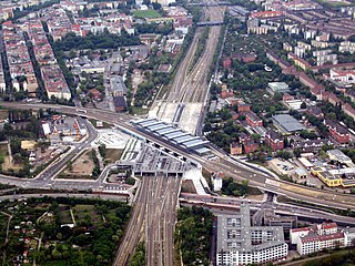
Potsdamer Platz with the site of the Potsdamer Bahnhof in September 2005. The long green strip is Tilla Durieux Park, the site of the former station and its approaches. The road running down its left (eastern) side is Gabriele Tergit Promenade, named after the German writer and journalist Gabriele Tergit (1894-1982), while the road running down the right (west) side is Linkstraße, a bygone thoroughfare from former times now resurrected, but realigned a few metres east of its old routePlan of the Berlin North–South mainline. The site of Potsdamer Bahnhof is in the bottom third of plan, on the route of the (new) main line, while the site of another former station Anhalter Bahnhof is almost parallel parkland, but further towards the South Eastern corner of the plan
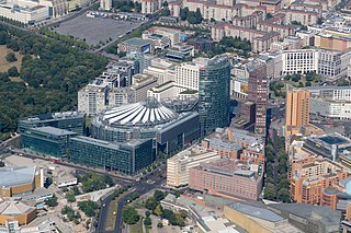
Today, a number of vast new developments can be seen around Potsdamer Platz. Despite some initial reservations, the new quarter has become a commercial success, and a must-see for the majority of visitors to Berlin. Where the Potsdamer Bahnhof once stood is a long landscaped strip of land named after the Austrian actress Tilla Durieux (1880–1971), stretching for 450 m down to the Landwehrkanal.
Despite appearances on the surface, long-distance trains have returned to the site, since the Berlin North–South mainline runs under the site of the Potsdamer Bahnhof, with the Potsdamer Platz station extending under some of the site of the Potsdamer Bahnhof.
A major fire at the DB Museum (German State Railway Museum) in Nuremberg on the night of 17/18 October 2005 destroyed a historical shed and 25 locomotives including the Adler replica featured in the centenary celebrations for the Potsdamer Bahnhof in 1938. Deutsche Bahn have apparently ordered another operational replica in time for the 175th anniversary celebrations in 2010, for the Nuremberg - Fürth railway line, Germany's first.
Potsdamer Platz is a public square and traffic intersection in the center of Berlin, Germany, lying about 1 km (1,100 yd) south of the Brandenburg Gate and the Reichstag, and close to the southeast corner of the Tiergarten park. It is named after the city of Potsdam, some 25 km (16 mi) to the south west, and marks the point where the old road from Potsdam passed through the city wall of Berlin at the Potsdam Gate. Initially, the open area near the city gate was used for military drills and parades. In the 19th into the 20th century, it developed from an intersection of suburban thoroughfares into the most bustling traffic intersection in Europe. The area was totally destroyed during World War II and then left desolate during the Cold War era when the Berlin Wall bisected its location. Since German reunification, Potsdamer Platz has been the site of major redevelopment projects.
The Berlin S-Bahn is a rapid transit railway system in and around Berlin, the capital city of Germany. It has been in operation under this name since December 1930, having been previously called the special tariff area Berliner Stadt-, Ring- und Vorortbahnen. It complements the Berlin U-Bahn and is the link to many outer-Berlin areas, such as Berlin Brandenburg Airport. As such, the Berlin S-Bahn blends elements of a commuter rail service and a rapid transit system.
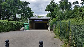
Berlin Jungfernheide is a railway station located at Charlottenburg-Nord, in the Charlottenburg-Wilmersdorf district of Berlin, served by the S-Bahn lines S41 and S42, the U-Bahn line U7 and Regional-Express trains of the Deutsche Bahn. Its name literally translates into "maidens' heathland"; it was named after the Jungfernheide, a former large forest in the proximity of this station.
Ebertstraße is a street in Berlin, the capital of Germany. It runs on a roughly north-south line from the Brandenburg Gate to Potsdamer Platz in the centre of the city.
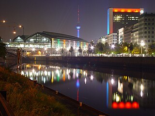
The Anhalter Bahnhof is a former railway terminus in Berlin, Germany, approximately 600 m (2,000 ft) southeast of Potsdamer Platz. Once one of Berlin's most important railway stations, it was severely damaged in World War II, and finally closed for traffic in 1952, when the GDR-owned Deutsche Reichsbahn rerouted all railway traffic between Berlin and places in the GDR avoiding the West Berlin area. The station's name lives on in the Berlin S-Bahn station of the same name, opened in October 1939 as part of the North-South S-Bahn link.
The Dresdner Bahnhof was a short-lived passenger railway terminus in Berlin, Germany, operating from 1875 to 1882 and handling train services to and from Dresden over the Berlin–Dresden railway.
Berlin Südkreuz station is a railway station in the German capital Berlin. The station was originally opened in 1898 and is an interchange station. The Berlin Ringbahn line of the Berlin S-Bahn metro railway is situated on the upper level and connects to the east and west, whilst the Anhalter Bahn and Dresdner Bahn intercity railway routes reach the station on the lower, north-south level. The station was extensively rebuilt between the late 1990s and 2006, and was renamed Berlin Südkreuz on 28 May 2006.
The Berlin Stadtbahn is the historic east-west elevated railway of Berlin. It runs from Ostbahnhof in the east to Charlottenburg in the west, connecting several of the most major sights of the German capital. The line is protected cultural heritage since 1995. It is often defined more simply as the slightly longer route between Ostkreuz and Westkreuz, although this is not technically correct.
The Ringbahn is a 37.5 km (23.3 mi) long circle route around Berlin's inner city area, on the Berlin S-Bahn network. Its course is made up of a pair of tracks used by S-Bahn trains and another parallel pair of tracks used by various regional, long distance and freight trains. The S-Bahn lines S41 and S42 provide a closed-loop continuous service without termini. Lines S45, S46 and S47 use a section of the southern and western ring, while lines S8 and S85 use sections of the eastern ring. The combined number of passengers is about 400,000 passengers a day. Due to its distinctive shape, the line is often referred to as the Hundekopf.
Berlin Potsdamer Platz is a railway station in Berlin. It is completely underground and situated under Potsdamer Platz in central Berlin. Regional and S-Bahn services call at the station, and it is also served by U-Bahn line U2.
Berlin Gesundbrunnen station is a railway station in Berlin, Germany. It is situated in the Gesundbrunnen district, part of the central Mitte borough, as an interconnection point between the northern Ringbahn and Nord-Süd Tunnel lines of the Berlin S-Bahn, as well as a regional and long distance station of the Deutsche Bahn network. The station is operated by the DB Station&Service subsidiary of Deutsche Bahn AG and is classified as a Category 1 station, one of 21 in Germany and four in Berlin, the others being Berlin Hauptbahnhof, Berlin Südkreuz and Berlin Ostbahnhof.
Berlin Nordbahnhof is a railway station in the Mitte district of Berlin, Germany. It is served by the Berlin S-Bahn and local bus and tram lines. Until 1950, the station was known as Stettiner Bahnhof.
Berlin-Schöneberg is a railway station in the district of Schöneberg, in the city of Berlin, Germany. It is a two-level exchange station serving the Wannseebahn suburban and the Ringbahn circular lines of the Berlin S-Bahn, with the lower level serving the Wannseebahn and the upper level the Ringbahn. The station lies just south of the Dominicusstraße and Sachsendamm streets, where local bus stops allow changing between S-Bahn and busses.
Julius-Leber-Brücke is a railway station in the Schöneberg district of Berlin. Located under a bridge over the cutting created for the Berlin-Potsdam-Magdeburg railway. It was officially opened on 2 May 2008 and is served by the S-Bahn line S1.
Berlin-Lichterfelde Ost station is on the Anhalt Suburban Line in Lichterfelde in the Berlin borough of Steglitz-Zehlendorf. It is served by S-Bahn line S25, S-Bahn line S26, and Regional-Express lines 3, 4 and 5.
The North–South S-Bahn Tunnel is the central section of the North–South transversal Berlin S-Bahn connection crossing the city centre. It is not to be confused with the Tunnel Nord-Süd-Fernbahn, the central tunnel part of the North–South main line used by intercity and regional trains. The S-Bahn North–South line encompasses the route from Bornholmer Straße and Gesundbrunnen via Friedrichstraße and Anhalter Bahnhof to Papestraße and Schöneberg.
The Berlin North-South main line, also called the North-South link (Nord-Süd-Verbindung) is an electrified railway line in Berlin which was opened in 2006. It is an important component of the “mushroom concept” (Pilzkonzept) adopted for long-distance and regional rail services through the city. Its core is an approximately 3.5 km (2.2 mi) long Tiergarten tunnel under the Tiergarten in Berlin. The tunnel section includes the underground level of Berlin Hauptbahnhof and the Potsdamer Platz regional station. The above-ground section of the line includes the Berlin Südkreuz station.
The Wannsee Railway is a suburban railway in Berlin running from Potsdamer Platz via the Ring line station of Schöneberg to Wannsee station on Großer Wannsee, a lake after which it is named. Today it is a section of the Berlin S-Bahn line S1.
S15 is a planned second north-south route for the Berlin S-Bahn, which will connect Berlin Hauptbahnhof to the Berlin Ringbahn to both north and south. The first section is under construction and is expected to go into operation in the first quarter of 2025.
The Berlin S-Bahn began on 8 August 1924 with the first section from Stettiner Vorortbahnhof to Bernau using steam locomotives. On 13 August 1961 it was broken up when the Berlin Wall was built, resulting in two sections: the eastern part and the western part. The western part experienced a massive strike which resulted in closure of several stations, after declining use. Attempts were made to reopen at various times but in the end, only three lines were finally opened after the strike. Since 9 November 1989, when the Berlin Wall was opened, the Berlin S-Bahn began to expand rapidly with their budgetary costs.
This page is based on this Wikipedia article Text is available under the CC BY-SA 4.0 license; additional terms may apply. Images, videos and audio are available under their respective licenses.