Berlin Görlitzer Bahnhof

Last updated • 6 min readFrom Wikipedia, The Free Encyclopedia
Berlin Görlitzer Bahnhof
Goerli1872-WEB.jpg
Empfangsgebäude des Görlitzer Bahnhofes in Berlin, an 1872 painting depicting the station entrance hall
General information
Location Friedrichshain-Kreuzberg, Berlin, Berlin
Germany
Construction
Architect August Orth
History
Opened1866
Closed1951

Görlitzer Bahnhof was the name of the Berlin railway terminus for the mainline link between the capital, Cottbus in Brandenburg and Görlitz in Lower Silesia (since 1945 Saxony). It stood overlooking Spreewaldplatz in the Outer Luisenstadt, the eastern part of Kreuzberg but wartime bombing and Cold War tensions led to its closure and eventual demolition.

Contents

The Görlitzer Bahnhof (Berlin U-Bahn) station was named after this historic station and is located on a different site nearby.

The rise

The station was designed by August Orth, an architect later responsible for the Emmauskirche in nearby Lausitzer Platz, and built between 1865 and 1867 in the Palazzo style of the Italian Renaissance. It formed part of a railway expansion project that would link Berlin with Cottbus and Görlitz, and then ultimately with cities such as Sagan (Żagań) and Breslau (Wrocław) (both in Poland since 1945) and Vienna in Austria.

On 13 June 1866 a military train bound for the Austro-Prussian war became the first train to leave the then incomplete station site. The connection was one of convenience because the military had built their barracks in neighbouring Wrangelstraße.

Shortly afterwards, on 13 September, a regular passenger service began between Berlin and Cottbus. By late 1867 the Berlin-Görlitz line was complete and the route, which passed through the countryside of the Spreewald and Lower Lusatia and the towns of Königs Wusterhausen, Lübben, and Lübbenau, officially opened on 31 December 1867. Although founded by a private company, owned by industrialist and "rail king" Bethel Henry Strousberg, the service was nationalised on 28 March 1882.

The new line proved an immediate success with the public. After only a few months, it was accommodating 70,000 travellers a day and during the whole of 1880, approximately 1.5 million people used Görlitzer Bahnhof. Its popularity had a stimulating effect on the surrounding area, with shops and cafés springing up in the neighbouring streets, helping to establish it as one of the liveliest in the city.

Aside from the transport of people, the line also served as a vital trade route connecting the capital with the cloth factories, and the brick and glass works of industrial Görlitz. Lausitz proved to be not only a rich source of Spreewald gherkins but also, more importantly, of coal.

A section of the 1902 Pharus Plan of Berlin showing Gorlitzer Bahnhof and the eastern Kreuzberg environs Karte Lohmuhleninsel Berlin.JPG
A section of the 1902 Pharus Plan of Berlin showing Görlitzer Bahnhof and the eastern Kreuzberg environs

Görlitzer Tunnel

In order to improve access between the neighbourhoods that emerged around Görlitzer Straße (the Wrangelkiez) and Wiener Straße (the Reichenberger Kiez), an underpass was constructed under the railway site. Opened to the public in 1910, this connected Oppelner Straße on the northern side with Liegnitzer Straße to the south. [1] This was officially known as the ‘Görlitzer Tunnel’, although it would later also acquire the nickname "Harnröhre“ (Urethra).

The fall

During World War II, the Allied aerial bombardments of 3 February 1945, which left 3,255 dead or missing and over 119,000 homeless in the surrounding Kreuzberg district, caused severe damage to the station. Nevertheless, by June, a mere month after the surrender of Berlin, a makeshift Görlitzer Bahnhof was back in service. [2]

The revival proved temporary, however. From 25 September 1946 all its long-distance trains were redirected to Schlesischer Bahnhof (renamed Ostbahnhof in 1950) on the central Stadtbahn. Furthermore, over the next few years the ongoing expansion of the electric S-Bahn system would supersede its role in the local network too. Ultimately though, it was the deepening crisis in political relations between East and West that sealed the station's fate, and made its position as a Western station operating an Eastern line untenable. It therefore came as no surprise when the GDR decided to close Görlitzer Bahnhof to passenger trains on 29 April 1951.

Although the complete absence of the railway on the 1954 Berlin city map suggests the station was subsequently demolished and cleared, it actually remained relatively undisturbed in its bombed-out state for ten years after the closure. The arrival of the Wall in 1961, however, quashed any hopes of a reconstruction.

Over the following decade or so all the remaining station buildings were demolished, beginning with the large platform hall in 1962 and the main reception area in 1967.

The remaining public buildings – which included two towers, various waiting rooms and a restaurant – were levelled in 1975 during a wave of demolitions during the 1970s that claimed many historic victims across the city. The reason given at the time for the demolition was that the buildings served no practical purpose in standing empty and as a result were being occupied by an "anti-social" element. The removal of these "ruins" would therefore be better for the image of West Berlin. [3] By 1976 the site lay mostly empty.

Continuing use of Görlitzer Bahnhof after closure

Although the station stood abandoned and the site lay undeveloped for over thirty years, the area was never dormant. Since the closure in 1951, the land and buildings were used variously for coal storage, as a scrapyard, an auto garage, and for other small enterprises. Furthermore, the northern goods side of the station site remained in active use by the Deutsche Reichsbahn for transporting freight between West and East Berlin, and for this reason a border crossing point stood on the bridge over the Landwehrkanal. This passage of freight was permanently discontinued on 30 June 1985. [1]

Between the years 1984 and 1987 a local swimming pool, the Spreewald Bad, an innovative structure designed by Christoph Langhof architects, was built on the site of the former station.

Before the remaining area from Skalitzer Straße up to the Görlitzer Ufer was developed into Görlitzer Park in the early 1990s, [4] it was a waste ground partly accessible by the public. This vacancy led to the site being occupied during the summer of 1989 by the Mutoid Waste Company, an anarchist art commune from London. The location was chosen in part because of its proximity to the Wall. On one memorable occasion the scrap metal artists created a "Peace Bird" contraption which featured a bird suspended high in the air which was able to roll along the railway tracks to the border point on the bridge and, in a gesture of peace towards the GDR, exhibit the bird to those in the east. [5]

Although the Görlitzer Tunnel remained in use until the beginning of the 1990s, the public access to the site prompted by the new park left it redundant. By the creation of a 'natural' arena in the centre of the park, the tunnel was largely destroyed, although its remains were incorporated into the design.

The remains

The remaining office building and one of the goods sheds TwoGoerliSheds.jpg
The remaining office building and one of the goods sheds

The only obvious physical remains of the station site are the two goods sheds, an old office building, the railway bridge and the remnants of the underpass visible in a crater in the centre of the park. Nevertheless, it is possible to follow part of the old railway route on foot, as it leads out of the park, over the Landwehrkanal and then comes to an end over Elsenstraße in Treptow, just before the original line would have met the ring of the S-bahn.

The historic building itself lives on in existing local names. In 1926, the local U-Bahn station Oranienstraße was renamed as Görlitzer Bahnhof to indicate the neighbouring mainline terminus but despite the latter's demise the U-bahn stop maintains the historical name, much like with the similarly doomed Anhalter Bahnhof. In addition to this, the road that runs alongside the western side of Görlitzer Park, was renamed Wiener Straße in 1873, because the first trains connecting Berlin and the Austrian capital Vienna left from Görlitzer Bahnhof. Likewise, the neighbouring squares Spreewaldplatz and Lausitzer Platz were named after the areas of countryside once accessible from its platforms.

Filming location

The 1966 film Funeral in Berlin used the front of the building, which still stood at that time, as the filming location for the fictional East Berlin "Marx-Engels-Platz 59". [6]

Related Research Articles

<span class="mw-page-title-main">Potsdamer Platz</span> Public square and traffic intersection in Berlin, Germany

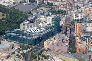
Potsdamer Platz is a public square and traffic intersection in the center of Berlin, Germany, lying about 1 km (1,100 yd) south of the Brandenburg Gate and the Reichstag, and close to the southeast corner of the Tiergarten park. It is named after the city of Potsdam, some 25 km (16 mi) to the south west, and marks the point where the old road from Potsdam passed through the city wall of Berlin at the Potsdam Gate. Initially, the open area near the city gate was used for military drills and parades. In the 19th into the 20th century, it developed from an intersection of suburban thoroughfares into the most bustling traffic intersection in Europe. The area was totally destroyed during World War II and then left desolate during the Cold War era when the Berlin Wall bisected its location. Since German reunification, Potsdamer Platz has been the site of major redevelopment projects.

<span class="mw-page-title-main">Kreuzberg</span> District of Berlin, Germany

Kreuzberg is a district of Berlin, Germany. It is part of the Friedrichshain-Kreuzberg borough located south of Mitte. During the Cold War era, it was one of the poorest areas of West Berlin, but since German reunification in 1990, it has become more gentrified and is known for its arts scene.

<span class="mw-page-title-main">Berlin S-Bahn</span> Rapid transit railway system in and around Berlin

The Berlin S-Bahn is a rapid transit railway system in and around Berlin, the capital city of Germany. It has been in operation under this name since December 1930, having been previously called the special tariff area Berliner Stadt-, Ring- und Vorortbahnen. It complements the Berlin U-Bahn and is the link to many outer-Berlin areas, such as Berlin Brandenburg Airport. As such, the Berlin S-Bahn blends elements of a commuter rail service and a rapid transit system.

<span class="mw-page-title-main">U2 (Berlin U-Bahn)</span> Underground transit line in Germany

U2 is a line of the Berlin U-Bahn. The U2 line starts at Pankow S-Bahn station, runs through the eastern city centre (Alexanderplatz) to Potsdamer Platz, the western city centre and finally to the Ruhleben terminal station.

<span class="mw-page-title-main">U7 (Berlin U-Bahn)</span> Rail line on the Berlin U-Bahn

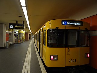
The U7 is a rail line on the Berlin U-Bahn. It runs completely underground for a length of 31.8 kilometres (19.8 mi) through 40 stations and connects Spandau, via Neukölln, to Gropiusstadt and Rudow. The U7 was originally the south-eastern branch of the Nord-Süd-Bahn (U6) that ran between the branching point at Belle-Alliance-Straße (Mehringdamm) and Grenzallee; however, in the 1960s, this stretch was separated from the rest of the line and extended at each end to form a new line.

<span class="mw-page-title-main">Möckernbrücke (Berlin U-Bahn)</span> Station of the Berlin U-Bahn

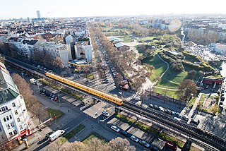
Möckernbrücke is a station of the Berlin U-Bahn network in the western Kreuzberg district, in the vicinity of Potsdamer Platz, named after a nearby bridge crossing the Landwehrkanal. It is served by lines U1, U3, and U7.

<span class="mw-page-title-main">Berlin Potsdamer Bahnhof</span> Railway station in Mitte, Germany

The Potsdamer Bahnhof is a former railway terminus in Berlin, Germany. It was the first railway station in Berlin, opening in 1838. It was located at Potsdamer Platz, about 1 km south of the Brandenburg Gate, and kick-started the transformation of Potsdamer Platz from an area of quiet villas near the south-east corner of the Tiergarten park into the bustling focal point that it eventually became. For more than a century it was the terminus for long-distance and suburban trains. Also located at this spot were underground stations on the Berlin U-Bahn and S-Bahn, and today's new underground Regionalbahnhof, known as Bahnhof Potsdamer Platz, while the short-lived M-Bahn crossed the site of the former terminus.

<span class="mw-page-title-main">Berlin Anhalter Bahnhof</span> Formerly terminus and today underground S-Bahn station in Berlin

The Anhalter Bahnhof is a former railway terminus in Berlin, Germany, approximately 600 m (2,000 ft) southeast of Potsdamer Platz. Once one of Berlin's most important railway stations, it was severely damaged in World War II, and finally closed for traffic in 1952, when the GDR-owned Deutsche Reichsbahn rerouted all railway traffic between Berlin and places in the GDR avoiding the West Berlin area. The station's name lives on in the Berlin S-Bahn station of the same name, opened in October 1939 as part of the North-South S-Bahn link.

<span class="mw-page-title-main">Paradestraße (Berlin U-Bahn)</span> Station of the Berlin U-Bahn

Paradestraße is a Berlin U-Bahn station on the U6 line. It was opened in 1927 as Flughafen (airport) and at that time provided the world's first direct connection between a metro system and an airport.

<span class="mw-page-title-main">Berlin Dresdner Bahnhof</span> Railway station in Friedrichshain-Kreuzberg, Germany

The Dresdner Bahnhof was a short-lived passenger railway terminus in Berlin, Germany, operating from 1875 to 1882 and handling train services to and from Dresden over the Berlin–Dresden railway.

<span class="mw-page-title-main">Berlin Ringbahn</span> Railway line in Germany

The Ringbahn is a 37.5 km (23.3 mi) long circle route around Berlin's inner city area, on the Berlin S-Bahn network. Its course is made up of a pair of tracks used by S-Bahn trains and another parallel pair of tracks used by various regional, long distance and freight trains. The S-Bahn lines S41 and S42 provide a closed-loop continuous service without termini. Lines S45, S46 and S47 use a section of the southern and western ring, while lines S8 and S85 use sections of the eastern ring. The combined number of passengers is about 400,000 passengers a day. Due to its distinctive shape, the line is often referred to as the Hundekopf.

<span class="mw-page-title-main">Berlin Potsdamer Platz station</span> Railway station in Berlin, Germany

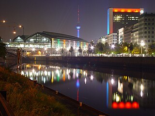
Berlin Potsdamer Platz is a railway station in Berlin. It is completely underground and situated under Potsdamer Platz in central Berlin. Regional and S-Bahn services call at the station, and it is also served by U-Bahn line U2.

<span class="mw-page-title-main">Berlin Nordbahnhof</span> Railway station in Berlin, Germany

Berlin Nordbahnhof is a railway station in the Mitte district of Berlin, Germany. It is served by the Berlin S-Bahn and local bus and tram lines. Until 1950, the station was known as Stettiner Bahnhof.

<span class="mw-page-title-main">Berlin-Schöneweide station</span> Railway station in Berlin, Germany

Berlin-Schöneweide is a railway station in Niederschöneweide, part of the Treptow-Köpenick borough of Berlin. It is served by the S-Bahn and regional trains, buses and trams. It was a terminal for long-distance trains until 2011.

<span class="mw-page-title-main">Berlin Nord-Süd Tunnel</span> Berlin metropolitan railway line

The North–South S-Bahn Tunnel is the central section of the North–South transversal Berlin S-Bahn connection crossing the city centre. It is not to be confused with the Tunnel Nord-Süd-Fernbahn, the central tunnel part of the North–South main line used by intercity and regional trains. The S-Bahn North–South line encompasses the route from Bornholmer Straße and Gesundbrunnen via Friedrichstraße and Anhalter Bahnhof to Papestraße and Schöneberg.

<span class="mw-page-title-main">Berlin–Görlitz railway</span> Railway line in Germany

The Berlin–Görlitz railway is a main line railway in the German states of Berlin, Brandenburg and Saxony, which was originally built and operated by the Berlin-Görlitz Railway Company. The line runs through Lusatia from Berlin via Cottbus to Görlitz. It is one of the oldest lines in Germany, opened in 1866 and 1867.

<span class="mw-page-title-main">Berlin Customs Wall</span> Ring wall in Berlin (1737–1860)

The Berlin Customs Wall was a ring wall around the historic city of Berlin, between 1737 and 1860; the wall itself had no defence function but was used to facilitate the levying of taxes on the import and export of goods (tariffs), which was the primary income of many cities at the time.

<span class="mw-page-title-main">Luisenstadt</span>

Luisenstadt is a former quarter (Stadtteil) of central Berlin, now divided between the present localities of Mitte and Kreuzberg. It gave its name to the Luisenstadt Canal and the Luisenstädtische Kirche.

<span class="mw-page-title-main">Cottbus Hauptbahnhof</span> Railway station in Brandenburg, Germany

Cottbus Hauptbahnhof (German) or Chóśebuz głowne dwórnišćo is one of the main railway stations of the German state of Brandenburg. It was called Cottbus station until 9 December 2018. It is located just south of central Cottbus. It is classified by Deutsche Bahn as a Category 2 station.

<span class="mw-page-title-main">Görlitzer Park</span> Public park in Berlin, Germany

Görlitzer Park is a major park and recreation area in the Kreuzberg district of Berlin. The 14-hectare park area contains, among other things, a petting zoo, several sports and football fields, and a small lake. At its north-west end is the Görlitzer Bahnhof U-Bahn station.

References

  1. 1 2 Berliner-unterwelten.de Archived 6 July 2009 at the Wayback Machine Berliner Unterwelten e.V.(in German)
  2. "History of Görlitzer Bahnhof" Archived 19 August 2010 at the Wayback Machine , www.goerlitzer-bahnhof.de (German)
  3. Kreuzberger-chronik.de (in German)
  4. Morgenpost.de Berliner Morgenpost, 29 April 2007 (German)
  5. Mutoid Waste Company im Sommer 1989 in West Berlin Archived 1 December 2009 at the Wayback Machine Tip, 21 August 2009 (German)
  6. "Harry Palmer (Michael Cane) Movie Site: Funeral in Berlin locations" . Retrieved 17 March 2023.

52°29′56″N13°25′52″E / 52.499°N 13.431°E / 52.499; 13.431